-
Welcome to this forum . We are a worldwide group with a common interest in Birmingham and its history. While here, please follow a few simple rules. We ask that you respect other members, thank those who have helped you and please keep your contributions on-topic with the thread.
We do hope you enjoy your visit. BHF Admin Team
You are using an out of date browser. It may not display this or other websites correctly.
You should upgrade or use an alternative browser.
You should upgrade or use an alternative browser.
Bull Street
- Thread starter Astoness
- Start date

Richard Dye
master brummie
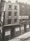
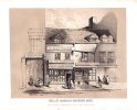
Is the new shop still standing? It has a lot of character.Crockford grove Bull street old shop ready for demolition 1905. New shop built 1907 picture from 1910.
If you look close at the picture . The sign says union passage so this means it must have gone before I can rember . In the. 1960 all those buildings were new in that part of bull street . I assume it would be were you went across bull street heading towards oasis market.
Pedrocut
Master Barmmie
A drawing of the Old Lamb House/Suffields in better days. Looks like Lamb House was originally made up of 3 distinct shops. Viv.
View attachment 118486
Ink Drawing The Old Lamb House, Bull Street, Birmingham By Jethro A Cossins. (Pulled down 1886)
(Birmingham Museums)

Interesting that that sketch of the Lamb House shows gables that weren't present at its demolition in 1886, nor going back as far as the 1835 sketch of post #422.
The Birmingham Daily Mail article "Destruction of the Oldest House in Birmingham" (18th May 1886) recounts that the building was to be stripped back to its original timbers for inspection and recording before being pulled down.
Perhaps the sketch above was part of that recording process and the author, Jethro Cossins (1830-1917), being an architect, was extrapolating the building's original construction from what the timbers revealed.
The Mail piece quotes a 1772 description of the vicinity (the "Welch End" neighbourhood) showing that the name "Lamb House" goes back at least that far, considerably pre-dating the time that my Allday relatives sold (and raised?) their "house lamb" from the premises in the 1820s. Prior to that, the house is claimed to have been the "Fox and Dogs", suggesting it was a public house.
(For those with access the Mail article is on the British Newspaper Archive)
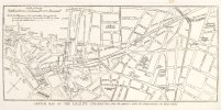
These two maps don’t have dates but we’re a long time apart the first one shows welch end . But not bull street. Then the later one shows corporation street as proposed new road. Very interesting when you look closely at them both.
Attachments
RobT
Acemeccanoman
Another photo of the LambThe lamb and as it was as haywards drapers.

Richard Dye
master brummie
Spectacular maps showing a chronological change in Birmingham! Thank you for sharing…These two maps don’t have dates but we’re a long time apart the first one shows welch end . But not bull street. Then the later one shows corporation street as proposed new road. Very interesting when you look closely at them both.
Fascinating. The first appears to be an extract from Joseph Hill's "Plan of Birmingham 1553 (conjectural)", which he put together in the 1890s, based on a detailed survey of Birmingham from that year of Queen Mary's reign.These two maps don’t have dates but we’re a long time apart the first one shows welch end . But not bull street. Then the later one shows corporation street as proposed new road. Very interesting when you look closely at them both.
Chappell Street became Bull St (I have a print of a 1731 map showing both names). I guess Priors Conygre Lane must be the forerunner of Steelhouse lane.
Birmingham library has a copy of the full 1553 plan, which you can see a low-res copy of here:

Early maps in the Heritage Research Area
For this week’s blog I thought I’d take a look at some of the early maps that we hold in our collections. Maps are interesting in that they give us an insight into how areas looked and were lived i…
 theironroom.wordpress.com
A translated and annotated copy of the original 1553 survey is available free on Google Books:
Richard Dye
master brummie
Fascinating! So much history, certainly was not remotely aware of….Fascinating. The first appears to be an extract from Joseph Hill's "Plan of Birmingham 1553 (conjectural)", which he put together in the 1890s, based on a detailed survey of Birmingham from that year of Queen Mary's reign.
Chappell Street became Bull St (I have a print of a 1731 map showing both names). I guess Priors Conygre Lane must be the forerunner of Steelhouse lane.
Birmingham library has a copy of the full 1553 plan, which you can see a low-res copy of here:
Early maps in the Heritage Research Area
For this week’s blog I thought I’d take a look at some of the early maps that we hold in our collections. Maps are interesting in that they give us an insight into how areas looked and were lived i…
A translated and annotated copy of the original 1553 survey is available free on Google Books:
Hello, does anyone have any photographs of Cropwood in the 1960s, specifically about a Sylvia Doughty who is my Mom who recently passed away. I’m wanting to find out more about her time at Cropwood. I understand she was there from aged 11 and then I understand she returned to work there in her early 20s before she met my father. Any information would be great. Thank you.


The first photo is a cropped version of that in post #391. Today's view bears very little resemblance to the 1950s view.
J T Modes interests me. Remember when ladies shops used 'Modes' in their title ? Like 'C&A Modes'. Probably a nodding reference to French couture. They sold dresses, coats, stockings and 'seperates' (another term no longer in use). In the 1950s, J T Modes offered 'Pay as you wear' credit options - a purchasing option probably ahead of its time in the 50s for this sort of purchase by women, who may not have been able to get credit in their own right.

J T Modes interests me. Remember when ladies shops used 'Modes' in their title ? Like 'C&A Modes'. Probably a nodding reference to French couture. They sold dresses, coats, stockings and 'seperates' (another term no longer in use). In the 1950s, J T Modes offered 'Pay as you wear' credit options - a purchasing option probably ahead of its time in the 50s for this sort of purchase by women, who may not have been able to get credit in their own right.
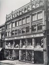
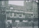
90-94 Bull Street before the Corporation Street development. Barrows at no 93, Thomas White, linen drapers, at no 92, William Hunt, mourning warehouse at no 84. Francis Walker,hairdresser and Miss Eliza Rowley, jeweller, were there in 1879, but gone in 1880. Thomas White was called that in 1876, but firm is listed as Oates & white in 1873. therefore the photo would be dated sometime between 1873 and 1880

A Sparks
master brummie
Number 90 has made his address very clear to see!!90-94 Bull Street before the Corporation Street development. Barrows at no 93, Thomas White, linen drapers, at no 92, William Hunt, mourning warehouse at no 84. Francis Walker,hairdresser and Miss Eliza Rowley, jeweller, were there in 1879, but gone in 1880. Thomas White was called that in 1876, but firm is listed as Oates & white in 1873. therefore the photo would be dated sometime between 1873 and 1880
View attachment 209007
Richard Dye
master brummie
That’s for VERY sure!Number 90 has made his address very clear to see!!
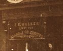
Re photo #436. Always thought Rimmel was a company formed in the 1960s offering cheap cosmetics to cater for young people. How wrong - they seem to have been around since the 1830s ! And by the time of the photo, they were well established and 'celebrated'.
Attachments
Last edited:
Cheap? Oh I can hear the '60s marketing team right now ... "No, no, no, never 'cheap', it's Beauty on a Budget, there's a world of difference!"Re photo #436. Always thought Rimmel was a company formed in the 1960s offering cheap cosmetics to cater for young people. How wrong - they seem to have been around since the 1830s ! And by the time of the photo, they were well established and 'celebrated'.

A c1870s/80s view similar to the photo in post #436 but showing more premises on Bull Street. Why were the windows covered ? Was it connected with demolition going on around/opposite these premises for the cutting of Corporation Street development ?

Last edited:
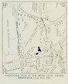
This one is described as a recess in Bull Street (c1870/80s). I've added a drawing of Bull Street to show its position - left of drawing (ie near the junction with High Street/Dale End)


A c1870s/80s view similar to the photo in post #436 but showing more premises on Bull Street. Why were the windows covered ? Was it connected with demolition going on around/opposite these premises for the cutting of Corporation Street development ?
View attachment 223545
As these buildings would have been demolished for the development, I am pretty sure thta your supposition is correct.
A very busy view of the Bull Street/Corporation Street junction. Judging by the number of bollards, it must have been a risky business crossing the road at this point. This was before the subway/underpass was built at this junction. Subsequently, as pedestrian underpasses went out of favour, it was filled in again !
Is that Dunn & Co the outfitters/tailors on the extreme right ?

Is that Dunn & Co the outfitters/tailors on the extreme right ?