I am researching my wife's ancestors and find from the 1861 census that Sarah Ames, her great great grandmother, lived in Brick Kiln Lane, Erdington at that time. Does anyone know exactly where Brick Kiln (or possibly Brickiln Lane) is or was? I have looked on modern maps and on old maps, the earliest being 1888 which has road names clearly shown - but no Brick Kiln Lane. It is of course possible that it disappeared or was renamed before 1888. It's approximate position can be deduced from the census. It was in census district 21, the boundaries of which are given on page 1 of the census results. Also following the route of the enumerator around the district it would seem that it was close to Summer Lane and Marsh Lane.
-
Welcome to this forum . We are a worldwide group with a common interest in Birmingham and its history. While here, please follow a few simple rules. We ask that you respect other members, thank those who have helped you and please keep your contributions on-topic with the thread.
We do hope you enjoy your visit. BHF Admin Team
You are using an out of date browser. It may not display this or other websites correctly.
You should upgrade or use an alternative browser.
You should upgrade or use an alternative browser.
Brick Kiln Lane, Erdington
- Thread starter Remus
- Start date
Old Boy
master brummie
Hi Remus,
Summer Lane and Marsh Lane are nowhere near each other so Brick Kiln Lane could not be close to both of them.. My addled memory may well be wrong but I seem to remember that Brick Kiln Lane was near the city centre off Newtown Row. In fact, it may well still be there.
Old Boy
Summer Lane and Marsh Lane are nowhere near each other so Brick Kiln Lane could not be close to both of them.. My addled memory may well be wrong but I seem to remember that Brick Kiln Lane was near the city centre off Newtown Row. In fact, it may well still be there.
Old Boy
Post 24 at https://birminghamhistory.co.uk/forum/showthread.php?t=34058&page=2 states that Brick kiln lane erdington became Gravelly lane
There was a scrap yard in the vicinity of Marsh Lane, Summer Road, South Grove and Gravelly Lane called Brewers. I was lead to believe that this was either a sand and gravel pit or a clay pit in the past, and was being used as a scrap yard to allow the backfill to settle.
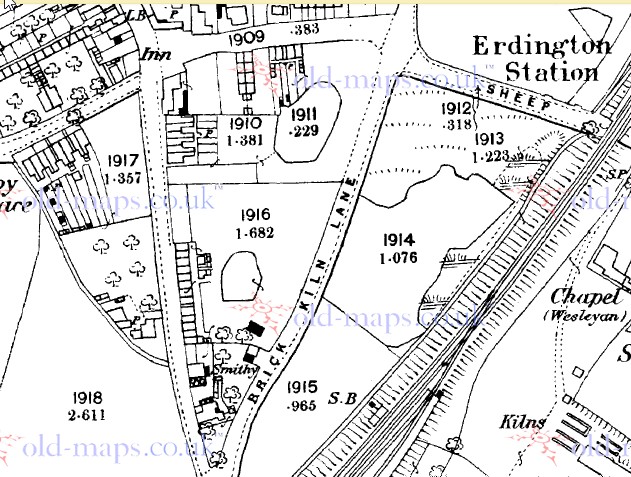
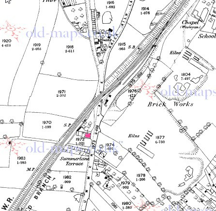
Have just found a map c 1889 which shows the very lower end of Gravelly lane as called Brick Kiln Lane (below). Unfortunately coverage on the old maps site (at that magnification which lists road names) stops just north of this. thre is a gap , but coverage on a c1884 map around oliver road shows it as gravelly lane. so it looks to me that it was only the end bit connecting to Station Road (or Sheep Lane as it was called then) that was called Brick Kiln Lane
When was that Morturn?. The 1963 Kellys lists a B. Brewer , motor parts at 60 Gravelly lane and an F. Brewer at 50/52 Gravelly Lane. These are shown on the c 1963 map. , and both seem to be in the area which once was Brick Kiln Lane marked on the c1889 map. I would think the 50/51 address seems more like a scrapyard from the map. Maps between the two either show a blank or the building on the 1963 map.
Mike B (Brian) Brewer did indeed have a small shop there what sold second hand car spar parts. It subsequently became a ten pin blowing shop when the Brewer family played ten pin bowling at the Pavilion. 50/52 is still a scrap yard as far as I know, it was owned by Fred Brewer, Brian's farther. The scrap yard where I think the sand pit may have been further north up Gravelly lane, the other side of Station Road. This was a scrap yard that extended over 2 to 3 acres
Dave M
Pheasey Born Bumper
Brewer`s are still up and running, been in the same place for years.
https://www.google.co.uk/maps/@52.5...m4!1e1!3m2!1sw21VYnEZHxRQ4HWbHyUd4A!2e0?hl=en
https://www.google.co.uk/maps/@52.5...m4!1e1!3m2!1sw21VYnEZHxRQ4HWbHyUd4A!2e0?hl=en
Frothblower
Lubrication In Moderation
Really interesting thread. The last time I was at Brewers, it was see my old Vauxhall Viva Estate after wrecking it in a accident the night before, about 30 years ago.
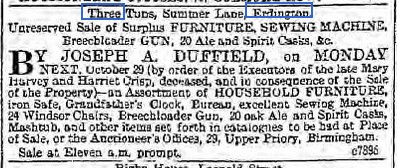
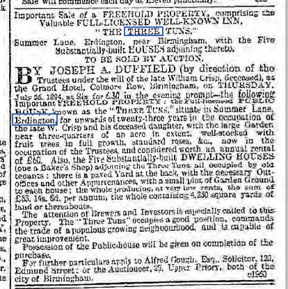
While trying to locate the position of the house occupied by my wife's ancestor (referred to in the original post of this thread) in the 1861 census for Erdington, I noticed a pub called the Three Tuns which I have seen no mention of elsewhere. In the 1861 census it was in Brick Kiln Lane and the licensee was Charles W Waldron. in the 1871 census it was in Brick Kiln Lane but the licensee was now William Crisp. In the 1881 census it was in Summer Lane, the licensee was still William Crisp. In 1891 the pub was in Summer Lane and the licensee was Harriet Crisp. Obviously the pub had not moved but the road name at that point had changed from Brick Kiln Lane to Summer Lane.
I "Googled" Three Tuns Erdington and the only relevant hits were from "British Newspapers 1600-1900 - Connected Histories". The following are copied and pasted:
754 Important Sale of a FREEHOLD PROPERTY, comprising the Valuable FULL-LICENSED WELL.KNOWN INN, 1 THE THREE TUNS', l Summer Lane, Erdington, near Birmingham, with the FPinn Substantially-built HOUSES adjoining thereto, TO BE SOLD BY AUCTION, Y JOSEPH A. DUFFIELD (by

for 6.15 proacpt-the following Importacct FREEHOLD PROERiTY : The Fall-licensed PUBLIC-HOUSE, kuawn an the "Trsttwg TUE-s." siseate in) Summer Lae Erdington, (for upwvards of wesecty-three years in the aoeopllo of the late W. Crisp ande his f-amlls-, with 0c ag
The above is all that is available without subscribing to the website.
It would appear that the Crisp family sold the pub sometime between 1891 and 1901 and the purchaser did not use the property as a public house.
I "Googled" Three Tuns Erdington and the only relevant hits were from "British Newspapers 1600-1900 - Connected Histories". The following are copied and pasted:
754 Important Sale of a FREEHOLD PROPERTY, comprising the Valuable FULL-LICENSED WELL.KNOWN INN, 1 THE THREE TUNS', l Summer Lane, Erdington, near Birmingham, with the FPinn Substantially-built HOUSES adjoining thereto, TO BE SOLD BY AUCTION, Y JOSEPH A. DUFFIELD (by
for 6.15 proacpt-the following Importacct FREEHOLD PROERiTY : The Fall-licensed PUBLIC-HOUSE, kuawn an the "Trsttwg TUE-s." siseate in) Summer Lae Erdington, (for upwvards of wesecty-three years in the aoeopllo of the late W. Crisp ande his f-amlls-, with 0c ag
The above is all that is available without subscribing to the website.
It would appear that the Crisp family sold the pub sometime between 1891 and 1901 and the purchaser did not use the property as a public house.
The only Inn shown on the 1889 map is where the Royal Oak stands todayon the corner of Marsh Lane, as the Three Tuns is listed as both Brick kiln lane and Summer lane(now Road) perhps it was situated where the 2 meet at the bottom of the triangle shown on the 1889 map.
In the 1861 census there are houses numbered 1-9 in Brick Kiln Lane - Summer Row. I suspect these are shown on the 1889 map as Summerlane Terrace. These are followed by a few more houses and the Three Tuns in Brick Kiln Lane. I think these on the 1889 map are the group just south of the railway bridge between the road and the railway.
In 1889 Summer Lane is shown as being south of the fork and probably but not clearly on the left to the north of the fork. Brick Kiln Lane is on the right to the north of the fork. I suspect that in 1861 and 1871 Brick Kiln Lane extended further south.
I have another map, OS Six Inch dated 1888-1913. I suspect that most of the data is nearer 1913 than 1888. This shows Summer Road south of the fork, Summer Lane north of the fork to the left and Gravelly Lane north of the fork to the right.
Remus
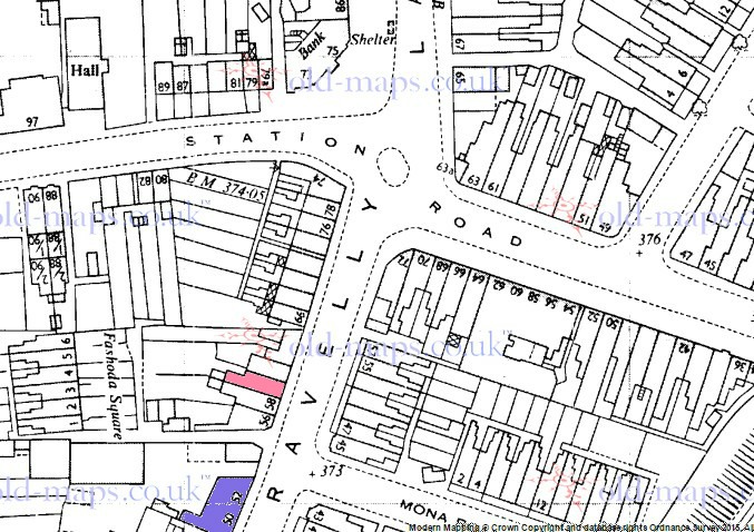
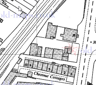
i think your suggestions are very probably correct, though have no evidence to definitely prove them. As I understand it this would make the building in red probably the Three Tuns as the pub would probably have been the building nearest the road. This (or an equivalent on the same site) is still there in 1963 and labelled no 76 Summer Road. The Summerlane terrace have been renamed Chestnut cottages. The whole area seems to have been cleared in 1973. The 1963 kellys lists 75/76 as Bakers of Erdington, furniture removers. If it was the same building in 1963 someone might have a picture of it
i think your suggestions are very probably correct, though have no evidence to definitely prove them. As I understand it this would make the building in red probably the Three Tuns as the pub would probably have been the building nearest the road. This (or an equivalent on the same site) is still there in 1963 and labelled no 76 Summer Road. The Summerlane terrace have been renamed Chestnut cottages. The whole area seems to have been cleared in 1973. The 1963 kellys lists 75/76 as Bakers of Erdington, furniture removers. If it was the same building in 1963 someone might have a picture of it
Hi Mikejee,
I have found a photograph showing 4 "Bakers of Erdington Ltd. Birmingham" furniture vans. The address on the vans is 76 Summer Road, Birmingham. They are parked in front of a building which I do not recognise. The photo is in the thread "Furniture removals" started by "postie" on 10 Aug 2014.
I have found a photograph showing 4 "Bakers of Erdington Ltd. Birmingham" furniture vans. The address on the vans is 76 Summer Road, Birmingham. They are parked in front of a building which I do not recognise. The photo is in the thread "Furniture removals" started by "postie" on 10 Aug 2014.
The small attached photograph is an enlarged part of the large one, an aerial photograph taken in 1937. I have had difficulty in extracting the part I need at an appropriate magnification and resolution. However I believe this shows the Three Tuns which is the large detached building left of centre at the top of the picture. The railway goods yard is out of site on the right. The road opposite the front of the building is Machin Road and the road running past the front is Summer Road (as it is called today and was in 1937, originally it was Brick Kiln Lane).
The terrace of cottages where my wife's great great grandmother lived in 1861 is just visible to the left (south) of the Three Tuns. Most recently these was called Chestnut Cottages, earlier they were Summerlane Terrace and before that they just had a Brick Kiln Lane address. I am satisfied that we have found what I was looking for and as a bonus we also have rediscovered the nearly forgotten Three Tuns.
There are other aerial photographs of Erdington at https://www.britainfromabove.org.uk
Hi I am related to Sarah Ames nee Standley too. Would love to hear from you but the post is a bit oldI am researching my wife's ancestors and find from the 1861 census that Sarah Ames, her great great grandmother, lived in Brick Kiln Lane, Erdington at that time. Does anyone know exactly where Brick Kiln (or possibly Brickiln Lane) is or was? I have looked on modern maps and on old maps, the earliest being 1888 which has road names clearly shown - but no Brick Kiln Lane. It is of course possible that it disappeared or was renamed before 1888. It's approximate position can be deduced from the census. It was in census district 21, the boundaries of which are given on page 1 of the census results. Also following the route of the enumerator around the district it would seem that it was close to Summer Lane and Marsh Lane.
I have posted an inquest report for you Tib on the link below about the death of Harriet Crisp’s sister at the Three Tuns Inn. Viv.
Crisp family of Erdington
This press cutting details the inquest of the sister of Harriet Crisp of the Three Tuns Inn Summer Lane. The deceased was Mrs Harvey, wife James Harvey. Verdict was given of accidental death. Viv.
birminghamhistory.co.uk
