• Welcome to this forum . We are a worldwide group with a common interest in Birmingham and its history. While here, please follow a few simple rules. We ask that you respect other members, thank those who have helped you and please keep your contributions on-topic with the thread.

    We do hope you enjoy your visit. BHF Admin Team

Bomb damage in unidentified streets

If you read my post (No.8) Old Mohawk, you will see I list most of the streets that were used by the trolleybuses in the central area of the city. Maybe not every street, such as Rea Street, is listed bit if you know the city you should be able to work out the routes.
The reason I made mention of some streets was because I could not find a suitable map to post.
Thanks I've been trying to work out a map from your info ....
encouragement.png
 
The Shoothill collection of photos contains many photos of bomb damaged streets which don't seem to have been identified.

Viv,

I have read this fascinating thread with great interest. However, what exactly is the Shoothill collection of photos? I have no doubt that they are of Birmingham but how do we know?

Chris Beresford (Old Boy)
 
Hi Chris. I should have explained at the beginning, apologies. As I understand it the images are from the Warwickshire Photographic Survey and (I think) Shoothill is the means by which all the photos have been made available. It allows a person to zoom in on a massive range of images.

All the images posted so far on this thread are described as "Bomb damage in unidentified Birmingham street". The first 12 I've posted above are of non-residential structures. The next ones I'll post will be residential properties. Will do this over the coming weeks. Thought it best to explore a few at a time, then follow up with more once we've exhausted any clues etc.

If we can name any (so far, we've identified one for certain) I'll feed back details to the Warwickshire Photographic project/and or Shoothill.

Viv.
 
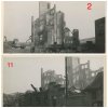
An observation. I think images #2 and #11 are the same group of ruined buildings Viv.
 

Attachments

  • image.jpg
    image.jpg
    242.6 KB · Views: 40
Hi Viv - image 12 is the corner of New Street and Bennetts Hill. How do I know ? Well the Shoothill site has the image on twice and one image is identified. It is not the easiest site to navigate !
 
Thanks Phil. So we now have #4 and #12 identified. That's good going. Now going to play my wild card on the #5 and # 6 photos. Was it New St Station/Queens Hotel, Station St view near junction with Dudley Street? I've seen this D J Norton photo and it set me wondering if it might be there. The station was bombed during the Blitz and the roof was replaced. Not too sure, but worth a shot. Viv.
 

Attachments

  • image.jpg
    image.jpg
    86.1 KB · Views: 59
Last edited:
Thanks Phil. So we now have #4 and #12 identified. That's good going. Now going to play my wild card on the #5 and # 6 photos. Was it New St Station/Queens Hotel, Station St view near junction with Dudley Street? I've seen this D J Norton photo and it set me wondering if it might be there. The station was bombed during the Blitz and the roof was replaced. Not too sure, but worth a shot. Viv.
Hi Viv - I think it could be somewhere near that location. I noticed a damaged trolley bus pole in the pic below of bomb damage on Gooch St near River Rea.

goochstriverrea.jpg
shoothill
 
Last edited:
Was it New St Station/Queens Hotel, Station St view near junction with Dudley Street? Viv.
Looking around the area, this 1933 aerial view shows a building lower left with interesting windows similar to those in image 5 but other features don't look quite right.
StatStQuDr.JPG
 
Last edited:
Thanks Phil. It's difficult to work out (an understatement !) But I do notice in #6 that there might be a more modern building (maybe 1920s or 30s) behind the frontage of the damaged building. Or is it my eyes playing tricks?

I also looked for any helpful maps of bombs which dropped. The map below could be helpful, although it's difficult to see the road names on the map. It covers 19/20 Nov 1940.- 1/2 Dec 1940. It calls it 'Accumulative' - not sure exactly what that means in the context of the dates. I've split it into two parts as I thought it might be easier to see. Not sure it is easier to see though as I'm doing this on an iPad mini, not on a laptop. Viv.
 

Attachments

  • image.jpg
    image.jpg
    244.6 KB · Views: 44
  • image.jpg
    image.jpg
    283.4 KB · Views: 41
Last edited:
Hi Chris. I should have explained at the beginning, apologies. As I understand it the images are from the Warwickshire Photographic Survey and (I think) Shoothill is the means by which all the photos have been made available. It allows a person to zoom in on a massive range of images.

All the images posted so far on this thread are described as "Bomb damage in unidentified Birmingham street". The first 12 I've posted above are of non-residential structures. The next ones I'll post will be residential properties. Will do this over the coming weeks. Thought it best to explore a few at a time, then follow up with more once we've exhausted any clues etc.

If we can name any (so far, we've identified one for certain) I'll feed back details to the Warwickshire Photographic project/and or Shoothill.

Viv.

Hi Viv,

I am sorry that I was remiss in failing to thank you for this information . Thanks again for a great thread.

Chris Beresford (Old Boy)
 
Looking at #1 photo I've been trying to work out the double wall in the foreground. It also has a white box inset into the wall. Anyone any ideas about these features? Suggests to me it might be near a canal, but not too sure. Viv.
 

Attachments

  • image.jpg
    image.jpg
    62.4 KB · Views: 54
Vivienne

I think you will find that the white box was a cellar head cover, during the war most cellars were utilised as shelters and if the building was bombed then it war more than likely that the inside access to the cellar would be covered in rubble. Obviously the outside one could also be covered so these brick & concrete surrounds were constructed to make the cellar heads more accessible.

If you look at this photo, you will several of the structures that you mention.
 

Attachments

  • Nechells Willis St - Francis St .jpg
    Nechells Willis St - Francis St .jpg
    164.2 KB · Views: 61
Looking at #1 photo I've been trying to work out the double wall in the foreground. Viv.
Hi Viv - I think it isn't a double wall, it looks like an abutment often put at the bottom of walls. The cellar cover Phil mentions seems to be stepped over it.
 
With the corbelled brickwork and low windowsills I think there is a great possibility that the bombed building may have been a school.
 
Thanks Phil and Phil. Do you know why abutments would be put at the bottom of walls? Viv.
 
Hi All,

I have studied these photos with bafflement but I wonder if No 9 could be a church. The entrance is an archway similar to that of St Thomas in Bath Row which has been cleared and developed into a Peace Garden. The original archway has been left in situ. This is only a suggestion but may be sorted out one way or the other if someone has a photo of the entrance to the Peace Garden.

Old Boy
 
Thanks Phil and Phil. Do you know why abutments would be put at the bottom of walls? Viv.


Vivienne,

As far as I am aware it was just an architectural feature that was used quite a lot in those times. They usually used a different colour or type of brick to make the effect stand out more.
 
Thanks Phil.

Re. your suggestion that it might have been a school, there aren't that many that were destroyed (rather than 'damaged' - as the buildings in the photo look completely destroyed). These are the schools that were destroyed:


English Martyr's RC Primary School, Evelyn Road, Sparkbrook. Building destroyed by enemy action 1940
Gower Street Council School, Lozells. Junior block destroyed by enemy action in 1940
Holy Family R C Family School, Oldknow Road, Small Heath. Building destroyed by enemy action in 1940
St. Michael's Temporary R C School, Floodgate Street. Building destroyed by enemy action in 1940


Viv.
 
Hi All,

I have studied these photos with bafflement but I wonder if No 9 could be a church. The entrance is an archway similar to that of St Thomas in Bath Row which has been cleared and developed into a Peace Garden. The original archway has been left in situ. This is only a suggestion but may be sorted out one way or the other if someone has a photo of the entrance to the Peace Garden.

Old Boy

Thanks Chris. These are photos of the church itself - pre and post WW2 damage. Can anyone spot any clues? Will also try and find a photo of the Peace Garden in the grounds of the Church. Viv.
 

Attachments

  • image.jpg
    image.jpg
    44.8 KB · Views: 26
  • image.jpg
    image.jpg
    70.6 KB · Views: 27
  • image.jpg
    image.jpg
    37.4 KB · Views: 28
  • image.jpg
    image.jpg
    36.4 KB · Views: 31
Last edited:
My thoughts so far are that the trolley bus overhead lines and tram tracks could narrow the search for some streets but so far I have not found them.

Image 5 has a fairly high quality building with a trolleybus overhead line in the pic. Trolleybus overhead cables were close together with a live wire and neutral return. Trams could use the steel tracks for the neutral return. Trams could however use the live wire on trolleybus overhead lines. There is a hint of a tram track in image 5. The sign showing a possible name appears to have been covered over with a pen on the original photo.

Image 6 is the same building as shown in image 5.

Image 8 shows tram tracks in the street and tram overhead lines can be seen. The pillars of the building have white horizontal sections which might identify the building in a forum street pic somewhere.

Image 9 shows overhead trolleybus or tram lines.

Image 10 shows trolleybus overhead lines and tram tracks.

Image 11 is the corner of New Street and Bennetts Hill. The Shoothill site has the image on twice and one image is identified.

The trolleybus shown in post#20 appears to be turning from Corporation St into Lower Priory and in other street pics on the forum there appears to be some bomb damage at bottom of Lower Priory although there were no high quality buildings down there.

Two identified bomb damage images below from Shoothill show typical trolleybus overhead lines and poles.

Moor Street - see the close together overhead lines.
moorstreet.jpg

Gooch Street near the River Rea shows a damaged trolleybus pole.
River Rea Gooch St.jpg
 
Very helpful Phil thanks. On image #5, you said that the name might have been erased for security reasons, so maybe it would have been a name easily identifiable by the enemy such as appear on maps. They might be names which indicate nearby railways e.g. GWR parcels office/booking office or the railway station name itself. In fact anything which if attacked would screw up the transportation of goods and people. However, I still have no idea what it might be. Viv.
 
Very helpful Phil thanks. On image #5, you said that the name might have been erased for security reasons, so maybe it would have been a name easily identifiable by the enemy such as appear on maps. Viv.

Not necessarily. Funf had friends all over the place.
 
Then your are, presumably, not old enough or led a very sheltered childhood Viv. Anyway your are heading in the correct direction with the German word for five.

I am sure another of the oldies on here will chip in with the answer. Well, this does seem to be the 'guesswork' thread.
 
ITMA's German spy, Viv. "This is Funf speaking...." A bit more sinister than Col. Chinstrap, ("Don't mind if I do") Mrs. Mopp ("Can I do you now sir?") and many others but, like them, never forgotten.

Chris
 
Back
Top