• Welcome to this forum . We are a worldwide group with a common interest in Birmingham and its history. While here, please follow a few simple rules. We ask that you respect other members, thank those who have helped you and please keep your contributions on-topic with the thread.

    We do hope you enjoy your visit. BHF Admin Team

Birmingham streets and courts

stuart1635

proper brummie kid
I have had some amazing help from members on this site as to indentifying some, unknown to me, old ston areas.
My ancesters came to Birmingham from Coaley in Gloucestershire and settled in Aston. No doubt they came fro th work.
and settled in Cromwell Road and Vicarage Street and Pritchett Street and I have already had wonderful help with maps and inmages.
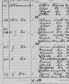
I am lost as regards 8 back of 6 Freemont, Park Mill, Aston, Park Road, Aston and back 24 Rocky Lane.
If someone could point me in the right direction where to start looking then once again I would be indebted to this
wonderful friendly and helpful group of Brummie.
Thank you
Stuart
 
Park Road is an easy one, it ran parallel to Vicarage Road (pink underline). Park Mills (green underline)? There was also a Park St (blue underline). 1938 map of Aston area...

0 - Park Road Park Mills.jpg
 
Below is a map of Rocky Lane from 1889. The arrow points to what I think is no. 24 but I'm not sure. By the time there's a map with numbers there's been a re-numbering. The layout of the houses appears to match the 1891 census but I'm sure someone will correct me if I'm wrong...

0 - Rocky Lane.jpg
 
Have attached a clip of 1871 census with my relative Christopher.
I am not very familier with how back courts were noted so what address
was Christopher living at?
 

Attachments

  • for post.JPG
    for post.JPG
    45.9 KB · Views: 15
That looks like he was just living at no. 8, not a back house. Which I think was this one (from 1889)...

0 - Freeman St..jpg
 
The way the houses are described and listed is most peculiar, and not as normally found. At that time numbering was consecutive, and below is what I believe numbering would have been. I am not certain but would tend to agree with MWS that it is most likely no 8, but would disagree by one house as to its position.

map 1880s showing freeman road with numbering.jpg
 
just noticed this thread is under our forum rules and guidance section i have moved it to a more appropriate section
 
Maybe a re-numbering but the 1950s map doesn't have a no. 1 but starts at no. 2.
Yes. you are right. I think that probably yours is the correct conclusion. Still do not like the way the enumerator has described the houses. At first I thought that the Richnond place was not listed, but see it now on next page.
 
You guys are really good, even by going to the census to check the previous or following page from that I posted. I can't thank the
members on this site enough. Thanks to Mkejee, who has helped before and MWS.
No doubt I will be back. I have a little trouble finding stuff on here. OK Brum is an enormous city. What I find difficult is when just surfing through peoples memories they might mention such and such photograph that they are talking about but I can't then find how to pull up the image in question. Never-the-less a great forum.
Stuart
 
Stuart, the reason some photos are missing is because the site was hacked a few years ago and we lost so many photos and material that members had posted over the years. Nevertheless, we've again been rebuilding the images available in threads, but as you can imagine it's a long process.
 
Back
Top