
-
Welcome to this forum . We are a worldwide group with a common interest in Birmingham and its history. While here, please follow a few simple rules. We ask that you respect other members, thank those who have helped you and please keep your contributions on-topic with the thread.
We do hope you enjoy your visit. BHF Admin Team
You are using an out of date browser. It may not display this or other websites correctly.
You should upgrade or use an alternative browser.
You should upgrade or use an alternative browser.
Birchfield Road Perry Barr
- Thread starter debi
- Start date


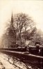
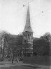
A seasonal view of Holy Trinity Church looking towards Birchfield Road. Sorry no date, but a lovely scene. Viv.

A Sparks
master brummie
My Sister remembers Billy Smarts Daughter attending Canterbury road girls School back in the late fifties, must have just been for the duration of the circuses visit.
Billy Smart's Circus always came to the old Dog Track land (the site of what's now One Stop) before the Lynton Square shopping precinct was built.
I went to Birchfield Road Juniors (late 50s/ early 60's) and we used to have the circus performer's children attending classes with us for the two weeks they were in Perry Barr.
yes it was,there was an infants,juniors and all girls senior,the headmistress was miss fairhead,deputy was mrs irish,i think there was a mrs Benson for art,she never liked anything i did as hard as i tried i couldnt draw a straight line with a ruler.i was in the netball team and lived around the corner at 75,Stoneleigh rd,this was in 1959/1963.I loved my school and my class teacher was miss jones,i think there was a mrs West and her feared daughter miss west,we had a miss grace come to teach occasionally as she was retired,she threw a blackboard rubber at my head and skimmed a parting in the middle of my hair,she also thumped me so hard in the back i thought my lungs had collapsed,evil woman.i wasnt the only pupil she did this tAm I correct in thinking that the Girls School was a secondary school? My memory's a bit misty after all these years.
Big Gee
 verall i loved the school and spent many hours after school practising netball shooting,always around there during school holidays playing kick the can,cricket,football etc with some of the lads from Birchfield boys school.Great times,I wish i could have a look round that school before i meet my maker.my name then was May Clarke.
Banjo
master brummie
In 1959 I lived 28 Birchfield Road right opposite Mansfield Rd (marked red). It was a big  Georgian type house and must have belonged to someone of note back in the day.
Does anyone remember Harry Bastable's shop? He was a speedway rider in the 40s/50s? and owned the motorcycle shop on Birchfield Rd. I bought a BSA A7 & Sidecar from him in 1963, for £55. Apologies regarding photo position as I can't get the hang of inserting them.
Georgian type house and must have belonged to someone of note back in the day.Does anyone remember Harry Bastable's shop? He was a speedway rider in the 40s/50s? and owned the motorcycle shop on Birchfield Rd. I bought a BSA A7 & Sidecar from him in 1963, for £55. Apologies regarding photo position as I can't get the hang of inserting them.
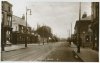
This junction changed dramatically when the underpass was put through Perry Barr. Today there's still a glimpse of the old Birchfield Road in the Barclay's Bank building (to the right on the postcard view). But the left-hand side has changed several times. The Crown and Cushion pub (left) was replaced with the large C&C, built behind the C&C seen in the postcard image. I wonder if Birchfiekd Road widening was planned way back in the 1930s when the large C&C was built.
In more modern times, the large C&C was replaced with another C&C as seen in the modern Streetview image. The yellow dot is roughly where the original Birchfield Road would have run. So over time, Birchfield Road must have almost doubled the width at this point Viv.
In more modern times, the large C&C was replaced with another C&C as seen in the modern Streetview image. The yellow dot is roughly where the original Birchfield Road would have run. So over time, Birchfield Road must have almost doubled the width at this point Viv.
Attachments


viv thats a cracking photo showing the first of the 3 crown and cushions....cant say as ive seen that one before...as you say just good old barclays bank left now...i have mentioned this before but the latest crown and cushion has been closed for several months now because of trouble with drug use etc....cant see it every re opening but to be honest its no great loss
lyn
lyn
Takes a bit of imagination to visualise Perry Barr having a traditional High Street. But yes, it once did. This section of Birchfield Road, near the original Crown and Cushion was the High Street. You can just make out the C&C set back on the left by the parked vehicle. The church spire in the distance is Christ Church, since demolished.
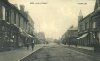
The building with the turret is roughly where Aston Lane joins the roundabout today.
And here's a comparison with the image I posted in post #395. The lower building next to the turreted building is the later Barclays Bank building. Surprisingly, the shops beyond the Barclays building are still there. But nowadays, the view to the left has largely been taken up with the wider Birchfield Road/underpass system.
Viv.
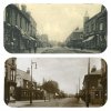
The building with the turret is roughly where Aston Lane joins the roundabout today.
And here's a comparison with the image I posted in post #395. The lower building next to the turreted building is the later Barclays Bank building. Surprisingly, the shops beyond the Barclays building are still there. But nowadays, the view to the left has largely been taken up with the wider Birchfield Road/underpass system.
Viv.
Last edited:

oldMohawk
gone but not forgotten
This photo of the Perry Barr library disappeared from this thread (before the upgrade) and my search across the BHF does not find it so I'm placing a copy here. The signs on the building read as 'Handsworth Public Library' - 'Birchfield Branch 1897' and overhead tram cables can be seen so the photo must have been taken after the introduction of the No 6 trams. An interesting car and motorbike are parked outside the library.
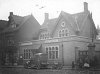
This image from https://www.search.birminghamimages.org.uk/search.aspx?SearchType=2&PageIndex=1&ThemeID=163
This image from https://www.search.birminghamimages.org.uk/search.aspx?SearchType=2&PageIndex=1&ThemeID=163
Last edited:
Great old shot of Birchfield Library, Mohawk. I knew that place like the back of my hand from when I was about 7 until I left the area when I was 25. Most of the staff were ladies, who never hesitated to "shush" anyone they thought was talking too loudly - just like a library should be. There was an upper gallery, and you had to ask permission to ascend there - I never really knew why, but that's how it was. I also remember a pair of very scruffy old geezers who read and re-read newspapers until closing time, doubtless because they'd got nowhere else to go. I'm not sure if it's still a library in 2016. The last time I looked it seemed to be some kind of neighbourhood centre.
G
G
phil the library has been gone for some years now still got the boards around where it stood but nothing done with the ground......wished i had taken some photos of it before it was demolished but to be honest it really did look like it would be there for years to come...i just cant understand why it had to go..

Pete Ex Pat
master brummie
Hi Mohawk, Just come across this photo of yours !!! Boy did it bring back some old Memories of when I used to work for a company called A,R, Hancox Ltd in Heathfield Road as a Pipefitter welder and allways got a lot of there Tools from Dodds in Perry Barr an pipe and fittings from Astbury and Madley around the corner from the office this was back before the underpass was built back in the 1960's Happy Days Ex Pat PeteI walked through Perry Barr hundreds of times well before the underpass was even thought of, in fact so long ago I caught the No 6 tram there. I must have seen that passageway and never knew it was called Crown Avenue. It just behind the car.
View attachment 105079
Photo date 1959


Di.Poppitt
GONE BUT NOT FORGOTTEN
I have just spent a couple of hours re-reading this post, another bit of the city lost for ever. I went to Canterbury Road School, danced at Enid Goodwins' lived in Stoneleigh Road when we got married and shopped in Brichfield Road. So many very happy memories.
Regards to the land in Wellhead Lane, my father used to talk about Villa playing there, it was their first ground. The land in Witton Lane was called Aston Lower Ground and used for entertainment, but I'm sure you all know
that.
Regards to the land in Wellhead Lane, my father used to talk about Villa playing there, it was their first ground. The land in Witton Lane was called Aston Lower Ground and used for entertainment, but I'm sure you all know
that.
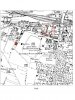
hi di..here is a map showing where villas ground used to be...not quite in wellhead lane di but just to the left of birchfield road with wellington road running alongside of it...what fascinates me about this map is that it shows a roman kiln..a fountain..antwerp house and anglesley house..just as an update birmingham city university (opened 1971) which was on the site of birchfield road school has now closed and i have heard will be demolished also the underpass ajacent to it has now been filled in..the area back then must have been quite lovely but if you remember how it looked in your day dont go back there it will reduce you to tears...just hang onto your memories..they wont change
lyn
lyn
Last edited:
oldMohawk
gone but not forgotten
Two aerial views of Birchfield Road and surroundings, one from 1920, and one from 2015
May 1920 and Canterbury Rd school and the Police Station in the centre. Above the school in the view a cricket match is in progress adjoining Normandy Rd. The old Birchfield Picture House is visible on the left with the library next to it and a large large house to the right. The Odeon had not yet been built. Trinity Road Church in the top of the view and Westminster Road prominent on the right.
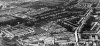
2015 and Canterbury Rd school still prominent in this modern view. The Birchfield Picture House and the Library have gone but the Odeon can be seen. The cricket field has gone but a field next to it is still there. Calthorpe Rd, bottom right in the view off Westminster Rd follows the road seen in the old pic but now with houses instead of small plots. A sizable plot of open land (possibly allotments) seen in the centre of the old pic with a track running through is mostly unchanged apart from what appears to be a school on the right.

A close up of Canterbury Rd school (complete with bike sheds) and that Normandy Rd cricket match.

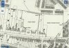
A 1905 map shows what we would call a 'sports complex' these days, cricket, tennis, bowling, and football, fronted by 'Hanover House' which must have been slightly important to show named on a map. Can't find any mention of it on the BHF.
The Birchfield Rd connection ... if I had been around in those days I would have travelled along Birchfield Rd to get there ...
May 1920 and Canterbury Rd school and the Police Station in the centre. Above the school in the view a cricket match is in progress adjoining Normandy Rd. The old Birchfield Picture House is visible on the left with the library next to it and a large large house to the right. The Odeon had not yet been built. Trinity Road Church in the top of the view and Westminster Road prominent on the right.
2015 and Canterbury Rd school still prominent in this modern view. The Birchfield Picture House and the Library have gone but the Odeon can be seen. The cricket field has gone but a field next to it is still there. Calthorpe Rd, bottom right in the view off Westminster Rd follows the road seen in the old pic but now with houses instead of small plots. A sizable plot of open land (possibly allotments) seen in the centre of the old pic with a track running through is mostly unchanged apart from what appears to be a school on the right.
A close up of Canterbury Rd school (complete with bike sheds) and that Normandy Rd cricket match.
A 1905 map shows what we would call a 'sports complex' these days, cricket, tennis, bowling, and football, fronted by 'Hanover House' which must have been slightly important to show named on a map. Can't find any mention of it on the BHF.
The Birchfield Rd connection ... if I had been around in those days I would have travelled along Birchfield Rd to get there ...
A Sparks
master brummie
hi di..here is a map showing where villas ground used to be...not quite in wellhead lane di but just to the left of birchfield road with wellington road running alongside of it...what fascinates me about this map is that it shows a roman kiln..a fountain..antwerp house and anglesley house..just as an update birmingham city university (opened 1971) which was on the site of birchfield road school has now closed and i have heard will be demolished also the underpass ajacent to it has now been filled in..the area back then must have been quite lovely but if you remember how it looked in your day dont go back there it will reduce you to tears...just hang onto your memories..they wont change
lyn
View attachment 107461
Interesting that the University site is to be demolished (I went to Birchfield Road Junior School) so know what it was like before.
What year is the map from?
I knew there were Roman remains on the site which is owned by Hiron's Nurseries
Looking at the GE aerial view at the rear of Willmore Rd houses (red pin is supposed to be roughly about #75) there's what looks like a gravelled/slabbed area between the end of the domestic gardens and the allotments (or garden centre land). Wonder if it's underneath that or a little further along?There looks like there's access to that area through the garden centre. Another opportunity for you to use your fine-tuned powers of persuasion Lyn if you get over there! Viv.
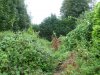
hi viv we can forget the allotments now..the kiln is on hirons land as sparks has already said....went down there yesterday and walked through hirons garden centre..carried on walking towards the back of it until i hit dense undergrowth at the back of wilmore st gardens...this is where i believe the kiln is/was...somewhere ajacent to nos 57 to 65 wilmore st...closest i can pin it down to but need to go back for a better look because the area is covered in those stinging nettles etc so need better footwear
Last edited:
Thanks Lyn. That's good of you. Maybe one for a winter visit! Viv.
oldMohawk
gone but not forgotten
Hi Lyn, I'm afraid I don't know the date but looking at the clothes worn in the photo I would say around 1920.cracking photo of trinity church OM i was christened there...any idea of the year
lyn
Phil
thanks phil...
viv forgot to post this with the photo i posted..not sure if its been on before but here is the link to the report re roman kiln it contains some great maps as well..i got it all printed off makes interesting reading
https://archaeologydataservice.ac.u...502-1/dissemination/pdf/birmingh2-28474_1.pdf
viv forgot to post this with the photo i posted..not sure if its been on before but here is the link to the report re roman kiln it contains some great maps as well..i got it all printed off makes interesting reading
https://archaeologydataservice.ac.u...502-1/dissemination/pdf/birmingh2-28474_1.pdf
Thanks Lyn. Interesting report. The kiln might not be something we'd recognise as a kiln even if there's any of it left. It might just look like rubble.
I've often wondered if additional sites around Perry Barr Village/Perry Village go that far back too given the rivulets, rivers and streams and its many mills scattered about. Some of the mills have a long history and perhaps these were sites of early furnaces ? All a bit speculative, but I imagine there's more than we think given the proximity to the Icknield Way.
The area was largely agricultural up until 80 years ago and I'd have loved to have had a poke around before all the estates were built. Viv.
I've often wondered if additional sites around Perry Barr Village/Perry Village go that far back too given the rivulets, rivers and streams and its many mills scattered about. Some of the mills have a long history and perhaps these were sites of early furnaces ? All a bit speculative, but I imagine there's more than we think given the proximity to the Icknield Way.
The area was largely agricultural up until 80 years ago and I'd have loved to have had a poke around before all the estates were built. Viv.
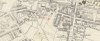
just a final map showing where no 224 wellington road was (mentioned in the excavation report) also showing the spot where the roman kiln was found..looking at this map it looks as though no 224 is down a gully but if you look at the map on post 404 is shows that it either had a very long garden or it was a wooded area
Attachments
oldMohawk
gone but not forgotten
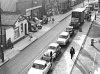
In my childhood and youth I must have gone along Birchfield Road at least 3 or 4 times a week. When I bought my first car I often sat in traffic jams there just like in this photo which is from the Library of Birmingham's collection.
Their information with the photo is
I cannot place where this is on Birchfield Road ... I can see the pub sign but the other side of the road does not look like it should do opposite the pub ... Brooks Opticians and a little shop named Cabin ... anyone got any ideas ?
Their information with the photo is
Date:1958
Description:Birchfield Road, Perry Barr, looking south before the construction of the Birchfield Road Underpass in the early 1960s. At the top right-hand corner is the inn sign outside the Old Crown & Cushion.
I cannot place where this is on Birchfield Road ... I can see the pub sign but the other side of the road does not look like it should do opposite the pub ... Brooks Opticians and a little shop named Cabin ... anyone got any ideas ?