-
Welcome to this forum . We are a worldwide group with a common interest in Birmingham and its history. While here, please follow a few simple rules. We ask that you respect other members, thank those who have helped you and please keep your contributions on-topic with the thread.
We do hope you enjoy your visit. BHF Admin Team
You are using an out of date browser. It may not display this or other websites correctly.
You should upgrade or use an alternative browser.
You should upgrade or use an alternative browser.
Banana warehouse/bbc masterchef building
- Thread starter Seanyb1986
- Start date


Seanyb1986
master brummie
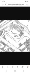
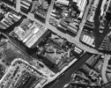
Some maps i have found so far, seems our banana warehouse had another wharf behind any some adjoining buildings, these maps are also before fellows morton and clayton built their premises next door
Attachments
-
 Screenshot_20230909_185817_Samsung Internet.jpg566.2 KB · Views: 10
 -
 Screenshot_20230909_190133_Samsung Internet.jpg875.6 KB · Views: 13
 -
 Screenshot_20230909_190627_Samsung Internet.jpg939.3 KB · Views: 12
 -
 Screenshot_20230909_190844_Samsung Internet.jpg943 KB · Views: 10
 -
 Screenshot_20230909_185817_Samsung Internet.jpg566.2 KB · Views: 7
Seanyb1986
master brummie


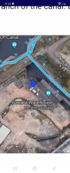
mike on the scottish maps...is this the warehouse with the rusty looking roof..for members who do not know just move the blue dot and the map will fade out to let us see what was there before


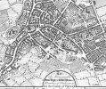
This is the area in 1852 Sean. I think Lower (Low) Fazeley Street must have later become Fazeley Street. Only one building close to (or actually on the site of the later banana warehouse) next to the canal. There doesn't yet appear to be the canal office buildings on Fazeley Street on this map although the building of that terrace must have been imminent.
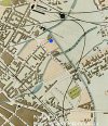
My blue dot on the second map attached below is I think the position of the later warehouse. Someone please let me know if that's incorrect Thanks
Viv

My blue dot on the second map attached below is I think the position of the later warehouse. Someone please let me know if that's incorrect Thanks
Viv
Attachments
Last edited:


Seanyb1986
master brummie
Im led to believe the fruit warehouse as it is was built in 1840 although it looks like it had many joining buildings that are now gone,
i may find evidence of old buildings as we strip all of the concrete that covers the site now, im interested in the positions of the old basins especially,
I'd like to see some maps 1935-1960 to see the avtivity at the fellows morton and clayton side of the site and their old basin,
i may have to dig that side of the site also as we progress, and im trying to pinpoint the old water pipes deep below ground
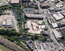
The building Ive mentioned on the 1852 map looks to me to be where the blue dot is on the aeriel view below.If you're exploring the foundations of that building these foundations probably date back to the early days of this branch of the canal. Let's hope so ! Viv.


Seanyb1986
master brummie
Yes the blue dot will be getting exposed in the future but we are redeveloping the whole site,
In your picture with the blue dot, we are basically uncovering everything that is concrete that you see, a large area
We have already started, roughly from the middle of the site outwards
There are lots of old buildings and basins that have come and gone
In your picture with the blue dot, we are basically uncovering everything that is concrete that you see, a large area
We have already started, roughly from the middle of the site outwards
There are lots of old buildings and basins that have come and gone
Seanyb1986
master brummie
The banana warehouse is staying, so im interested in the whole area around the warehouse right up to fazeley street and right across to and including the fellows morton and clayton building, these areas we will be digging and uncovering what was there before
Attachments
!731 Survey of the area with a road called Lake Meadow Hill running through. I read there were a lot of springs in the area and that it was part of the Gooch Estate.
In the photo of the site there is an interesting boundary line in the car park. Is it a watercourse or ditch?
There is an interesting document to read from Historic England about the area which is online.
In the photo of the site there is an interesting boundary line in the car park. Is it a watercourse or ditch?
There is an interesting document to read from Historic England about the area which is online.
Attachments

Seanyb1986
master brummie
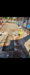
Work has begun on excavating where that car park was, that whole area is now cleared and ready for stripping, lots of cobbles
Attachments


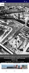
This might be of interest - ignore the yellow marks, I 'borrowed ' this from here https://grand-union.org.uk/junction-works/junction-works/
It's from Ackermans Panoramic 1847. Theres a clear layout of buildings, although can't be certain of accuracy. This shows a very interesting site with the two short branches/basins of Warwick Bar making easier loading/unloading away from the main Bar. Viv.

It's from Ackermans Panoramic 1847. Theres a clear layout of buildings, although can't be certain of accuracy. This shows a very interesting site with the two short branches/basins of Warwick Bar making easier loading/unloading away from the main Bar. Viv.
Last edited:
Great photos Sean.
You probably already know the site was, in the past, in use by a French cement and aggregates company (Lafarge). Viv
Image from Google Streetview 2008. Appearing on images until 2015.

You probably already know the site was, in the past, in use by a French cement and aggregates company (Lafarge). Viv
Image from Google Streetview 2008. Appearing on images until 2015.
Last edited:
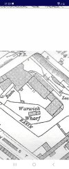
The 1845 PO directly seems to list the occupant as the Warwick & Birmingham canal Co, hence the name Warwick wharf. But the 1841 Pigot's directory lists them as at Bartholemew St, suggesting they moved there between those two directories (remembering that date is publication date, not survey date). The canal opened 1844, so that would fit.

Seanyb1986
master brummie
Any pictures of fellows morton and clayton basin after 1935??
no date sean but this one of fellows morton and clayton wharfAny pictures of fellows morton and clayton basin after 1935??
.jpg")
Seanyb1986
master brummie
Thats the area i'd like to see more of yes, that basin, and how far towards fazeley street it went
Seanyb1986
master brummie

sean cant you see how far it went by looking on this map...im not sure because i cant see a wharf named fellow morton and claytonThats the area i'd like to see more of yes, that basin, and how far towards fazeley street it went
I'm getting a bit confused as to where the area you want is. Have you seen this page from Ray Schill, showing the Fellows Morton & clayton land use. I find the later map on the right ver confusing , especially the numbering, not all of which seems to make sense to me.

I found these old papers, the sketched map below is dated 1873 but it might help with layout and position of the various buildings.These papers were from the Rowington Records link here
Viv


Viv
Attachments


Last edited:
Seanyb1986
master brummie
Mikejee That has answered a few questions, it looks as though fellows used the whole area for a time, leasing it from the grand junction company (number 1), before building their own warehouse in 1935 (number 4) it seems numbers 4 and 5 are mixed up in the index