• Welcome to this forum . We are a worldwide group with a common interest in Birmingham and its history. While here, please follow a few simple rules. We ask that you respect other members, thank those who have helped you and please keep your contributions on-topic with the thread.

    We do hope you enjoy your visit. BHF Admin Team

B8 Place Names

B14

New Member
Can someone please help explain the boundaries between the different localities in B8 as they seem to all merge together?

I'm thinking of Saltley, Washwood Heath, Alum Rock and Ward End. Maybe I have missed some more?
 
I think you have all of them. If you go to google maps and type in B8 it gives an outline of the whole area.

There used to be a sign on the Alum Rock Road after the Rock indicating where Saltley ended and Alum Rock began. I don't think it's there any more but it always surprised me that the boundary was not earlier. Can vaguely remember a similar sign on Washwood Heath Road but can't recall where it was.

Going back to the google map, when you type in the roads some come up with an area - Highfield Road, Saltley - Morris Road, Ward End - Clodeshall Road, Alum Rock.
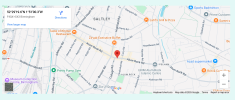
Really useful thanks - boundary seems to be here according to History of Bham website:

1745248418689.png

https://billdargue.jimdofree.com/placenames-gazetteer-a-to-y/places-r/the-rock/

Would be good to get some sense of the Saltley/Washwood Heath boundary
 
Back
Top