
-
Welcome to this forum . We are a worldwide group with a common interest in Birmingham and its history. While here, please follow a few simple rules. We ask that you respect other members, thank those who have helped you and please keep your contributions on-topic with the thread.
We do hope you enjoy your visit. BHF Admin Team
You are using an out of date browser. It may not display this or other websites correctly.
You should upgrade or use an alternative browser.
You should upgrade or use an alternative browser.
Aston Cottage shown on the Josiah Robins Town of Birmingham map 1819/20
- Thread starter Vivienne14
- Start date


BrummieGeoff
Sparkhill Lad
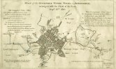
It's interesting to see that Josiah Robins also shows the "Aston Cottage" property on his 1810 Water Works Plan .... although he doesn't name it.On Josiah Robins, the Library of Birmingham notes to the Robins map say:
Josiah Robins was born c.1776. He set up as a surveyor in 1808 producing a map of Brewood parish, Staffordshire, together with James Sherriff. In 1818 he was joined by Cornelius Robins and in 1821 by Ebenezer Robins, both possibly his sons. From 1835 until 1839, he is listed in trade directories as of Aston Brook, where he died 23 December 1844, aged 68. He known to have produced a Plan of Birmingham waterworks [1811] and enclosure maps of Erdington & Witton. He was a major landowner in Aston, and also owned property in Handsworth and in Llandanwg, Merionethshire. In his will he left money and land for the building of St. Mary’s, Aston Brook.

Or is it a pool?

great map ive saved it thanks geoff...i know for sure from other maps that the brook ran under paddington st where i was born and ive just noticed padding brook is on the map and it looks to me as though it is more or less where paddington st was so maybe paddington st was named after padding brook...just a thoughtIt's interesting to see that Josiah Robins also shows the "Aston Cottage" property on his 1810 Water Works Plan .... although he doesn't name it.
View attachment 233485
lyn
Last edited:
BrummieGeoff
Sparkhill Lad
I don't think it's a hill. It's shown on the map in Post #18 as the mill pool for Aston Brook Mill.On the waterworks map above Aston Cottage is placed on the left of Aston Brook. To the right of the brook is another building and above it appears to be a hill ? would this be Round Hills ?
BrummieGeoff
Sparkhill Lad
Are you referring to "Pudding Brook" Lyn .... that I think ran behind Edgbaston Street?great map ive saved it thanks geoff...i know for sure from other maps that the brook ran under paddington st where i was born and ive just noticed padding brook is on the map and it looks to me as though it is more or less where paddington st was so maybe paddington st was named after padding brook...just a thought
lyn
lyn
lyn

pjmburns
master brummie
That's interesting - I found this entry in 1849 White's DirectoryOn the waterworks map above Aston Cottage is placed on the left of Aston Brook. To the right of the brook is another building and above it appears to be a hill ? would this be Round Hills ?

silly me geoff the u looked like an a to meAre you referring to "Pudding Brook" Lyn .... that I think ran behind Edgbaston Street?
 must go to spec savers soon lol
lyn
The late Bill Dargue on Roundhill(s) history:
The area between what is now New Town Row and Aston Road was known as (The) Round Hill/s. Its first mention is probably when the land was sold as an estate in 1596 by Sir Thomas Holte to Roger Pemberton, a Birmingham goldsmith. In a deed of 1795 Near Round Hill and Far Round Hill (probably field names) are referred to, so-named presumably with reference to Aston Hall.
Round Hill later seems to have been used as the name of the hamlet and may have been a streetname, possibly the lower end of Sutton Street, until the mid-19th century. The 1841 census lists some 30 dwellings and a population of about 150 ....
By 1891 the name existed only as a house name, Round Hill Cottage in Cheshire Street. That street is now gone, but it lay just north of Pool Street.
There appear to have been two Round Hills. The one is a little to the south of the former, lying between Miller Street and Brewery Street. It is shown on Blood's map of 1857. Land here belonging to the Keirle family is recorded in 1590.
The area between what is now New Town Row and Aston Road was known as (The) Round Hill/s. Its first mention is probably when the land was sold as an estate in 1596 by Sir Thomas Holte to Roger Pemberton, a Birmingham goldsmith. In a deed of 1795 Near Round Hill and Far Round Hill (probably field names) are referred to, so-named presumably with reference to Aston Hall.
Round Hill later seems to have been used as the name of the hamlet and may have been a streetname, possibly the lower end of Sutton Street, until the mid-19th century. The 1841 census lists some 30 dwellings and a population of about 150 ....
By 1891 the name existed only as a house name, Round Hill Cottage in Cheshire Street. That street is now gone, but it lay just north of Pool Street.
There appear to have been two Round Hills. The one is a little to the south of the former, lying between Miller Street and Brewery Street. It is shown on Blood's map of 1857. Land here belonging to the Keirle family is recorded in 1590.