• Welcome to this forum . We are a worldwide group with a common interest in Birmingham and its history. While here, please follow a few simple rules. We ask that you respect other members, thank those who have helped you and please keep your contributions on-topic with the thread.

    We do hope you enjoy your visit. BHF Admin Team

Asbury Cottage Newton

Vivienne14

Kentish Brummie Moderator
Staff member
Following a discussion about a cottage on a postcard labelled
"Great Bar", several ideas were explored on another thread to identify the location of the cottage in the image. Asbury Cottage on the Newton Road Great Barr was one possibility explored. https://birminghamhistory.co.uk/forum/index.php?threads/great-barr-cottage.48449/page-5#post-608617

This thread covers some of the discussion from that thread which specifically looked at the cottage which was once the home of Bishop Asbury's family.

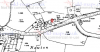
I believe at one time there were more cottages around Asbury Cottage, almost forming a hamlet. I wonder if anyone knows if there was once a cluster of cottages and a pub/inn near the Asbury Cottage/Newton on old maps ?

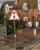
The current day view from Streetview is below. Viv.
 

Attachments

  • image.jpeg
    image.jpeg
    145.1 KB · Views: 3
All that's left of Asbury Cottage/cottages is this (red circle). It originally formed part of a larger group. Just for info. Viv.

image.jpeg
 
The cottage(s) adjoining Asbury Cottage must have come out onto what is now the (wider ?) Newton Road. I also notice there's a passageway behind the Cottage. Viv.
 
I've studied this again this afternoon and I think this is the cluster of buildings containing Bishop Asbury's Cottage
image.jpeg

image.jpeg


In the 1964 photo below you're looking down Newton Road - the area immediatly in front is where another building (possibly connected to the cottages) once stood. Road widening took up this space. The red dot is the edge of Bishop Asbury's Cottage - but only the bit we still see today, it was originally longer.
image.jpeg

Rear view of cottage today.
image.jpeg


Viv.
 
Last edited:
There's one more separate point to note, and that's about which cottage was actually the Bishops ? There are two cottages contained within the terrace in the B&W image in post #3. We know there has been speculation about whether the correct cottage had been demolished. But if it was in the way of a road widening scheme, I doubt, in any case, they'd have listened to preserving it in the 1960s. Viv.
 
A couple of aerial views of Newton Rd with Bishop Asbury's cottage marked red dots. The date of these pics is 1947.
2NewtonRd1947.JPG
Newton1947.JPG
 
This demonstrates how the cottage(s)/buildings would have protruded out across the road using the 1964 image. This whole part of Newton Road was redeveloped to make way for the wider road and a subway. Features such as grass verges marking road edges etc completely disappeared as a result. Viv.

image.jpeg
 
This is a nice challenge. I haven't cracked the exact layout of the cottages yet (looking at Phil's 1940s aeriel views).

For info. From "On the trail of John Wesley", by J K Cheetham. Viv.
image.jpeg
 
The Bishop's mother turned to Methodism after the death of her daughter (the Bishop's sister) She held prayer meetings in the cottage. This is allegedly the room used. Viv.image.jpeg
 
Trying to build up a picture of the 'hamlet' around Newton. The Malt Shovel further along the Newton Road and next to the Bishop's cottage once looked like this. It seems to have had a brewery alongside - Darby's. (Not surprising as there was a small stream at the rear). This seems to have been set further back off the early Newton Road (red dot). I wonder if this is the brewery which owned the Bishop's cottage terrace.

image.jpeg

Just beyond this point there was a more acute turn in the road and on the opposite side there was another pub "The New Inns" later "The Newton". A replacement is still there on the corner of Bowstoke Road.

Before changes to Newton Road, the Bishops terrace of cottages reached halfway across the later and wider Newton Road footprint. I can start to see how this and the pubs would have amounted to a hamlet. We also have to remember that the road changes at this point would have dramatically transformed this part of Newton Road, making visualising all this quite difficult.

What exactly was the building to the right of the 'L' shaped Bishops cottage terrace ? This too would have spread onto the later, wider Newton Road footprint. Viv.

PS Incidentally I think this part of Great Barr was at one time regarded as Perry Barr. Viv
 
Malt Shovel sounds a bit rough - or maybe a dodgy landlord Pedro.

This is how I visualise the cottage buildings in relation to the Newton Road - apologies, a bit niaive ! Viv.
image.jpeg
 
Pedrocut's map in post #9 shows an interesting cluster of buildings around the Asbury Cottage. It's a much bigger group of buildings than we've seen on other maps. Now trying to work out what it tells us.

The first map is 1885, the second is 1920s.

The main conclusion I've reached so far, is that the Malt Shovel seems to be marked as part of that group of buildings. Interesting. Viv.

image.jpeg
 
Now realised the building attached to the end of the cottage terrace in the first photo is The Malt Shovel Inn. Was the building next to the Inn a brewery ? Or was it a farm building ?

Can anyone tell me when the current Malt Shovel on Newton Road was built please ? It seems to be on the 1940s maps in post #6, but a little further along on Newton Road (see modern Google image below). Viv.

image.jpeg


Modern day aeriel view (Google)

image.jpeg
 
You might already know this - not sure but think the present day Inn is in a different place now. See attached maps - first 1916 and second 1937.
 

Attachments

  • upload_2018-1-1_11-39-19.png
    upload_2018-1-1_11-39-19.png
    167.5 KB · Views: 10
  • upload_2018-1-1_11-39-55.png
    upload_2018-1-1_11-39-55.png
    171.2 KB · Views: 10
CF32B475-EDD4-47D2-AEC4-ABA0A5196FC8.jpeg D4F11828-B7AF-44BA-8127-A24B2F7F46F4.jpeg

This is from September 1951 the Birmingham Gazette. So it seems it was more allied to West Brom? The Allen Memorial Congregational Church, Great Barr. Where was it ?
 
Is it the one you can see on the second map in my post above. Sorry can't see post numbers on phone.
 
Thanks Janice. Your second map shows the current Malt Shovel. Your first map shows the earlier Malt Shovel when it was part of a group of buildings around Asbury Cottage. Do you have a date please for the second map ? Viv.
 
Re post #22. Also thought at first he was wearing sunglasses !

Life at the cottage as a young boy meant he learned a lot of life as shown in the extracts attached. They're from Wigger's book "American Saint: Francis Asbury and the Methodists".

Proximity to the Malt Shovel meant he would have experienced much first hand. There's also mention of a "brewery nearby". It's suggested that this was a less that respectful area. Asbury's apprenticeship at a forge is also mentioned (Would this have been near the cottage ?).

There's mention of a structure attached to the cottage housing tools. I think this structure can be seen on earlier maps.

Other things we can glean are his mother's religious meetings in the cottage which could hold up to twenty-four people.

This background plus the visit of Wesley to the area all helped with Asbury's preparation for his move to America. And having said all this he was little known in this country. But still admired by American's who regularly visit his early home as demonstrated by post #24. Viv.
 

Attachments

  • image.jpeg
    image.jpeg
    122.2 KB · Views: 4
Thanks Janice. Your second map shows the current Malt Shovel. Your first map shows the earlier Malt Shovel when it was part of a group of buildings around Asbury Cottage. Do you have a date please for the second map ? Viv.
It was 1937. The other map of 1921 is a different scale but as far as I can tell it was still in its original position so it must have moved between those 1921 and 1937 (ish as map dates are always a bit different to survey dates).
 
Last edited:
Thanks Janice. The New Inns was across the road. Mr Wilson must have opposed the licence fearing competition from the new Malt Shovel which had moved nearer to his pub ! Viv.
 
So the forge wouldn't have been near the Cottage then Alan.

Now had a look at the old maps and drawn onto a b/w modern Google satellite image, the layout of the buildings as I see them. This is not to scale or accurately sized, just a rough guide. But it clearly shows how this cluster of buildings would have straggled the 1960s widened Newton Road.

Again apologies for the amateur drawing. These are the labels:
A. Store for gardening tools etc ? Rather large though. (demolished when ?)
B. Asbury's Cottage (built mid 17th century)
C. Second Cottage (built mid 17th century - demolished 1960s ?)
D. The (old) Malt Shovel Inn (demolished when ?)
E. A brewery (demolished when ?)
F. Stables ? Workshops ? (demolished when ?)
G. The (later) Malt Shovel Inn (built 1928)

image.jpeg


1920s map for comparison. Viv.
image.jpeg
 
Back
Top