• Welcome to this forum . We are a worldwide group with a common interest in Birmingham and its history. While here, please follow a few simple rules. We ask that you respect other members, thank those who have helped you and please keep your contributions on-topic with the thread.

    We do hope you enjoy your visit. BHF Admin Team

Ann Street house numbers

cuppateabiscuit

master brummie
Hi,
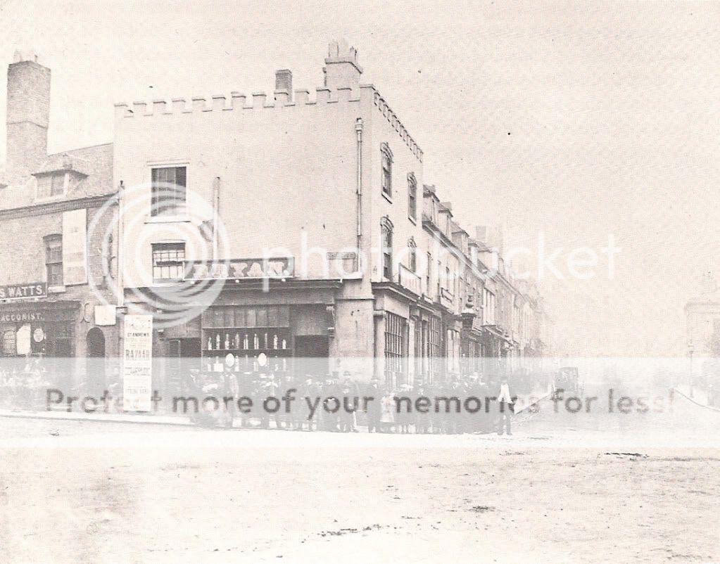
I am trying to find out house numbers for the section of Ann Street where the Council House was built, starting with the crenelated building on the corner. Does anyone have any idea what the numbering was?
Jenni
 
Numbering is mentioned in #36 and #37 on that thread. I did step through one of the census returns to work out some of the numbering. And Mike also identified some of the numbering further up the street.
I was particularly interested in number 27 and I think that we worked out that it was about half way along on the 'council house' side.
 
Looking at pre and post council house directories, the council house seems to have run from 25-41 Ann St.
mike
 
The Council House was not built on Ann Street. It may have been the closest to Ann Street at the eastern end. Much of the corner of Ann Street and Congreve Street was demolished and the Council House was built quite a bit further back I think. I am not sure if it has been determined where Ann St. ended and Colmore began but it looks like all of the numbers mentioned would have been accomodated by Ann St. Would Allins on the corner not have been #1. What number would Christ Church have been...if that was considered to be on Ann Street.
Perhaps Allins was on Congreve Street which is where the entance was.
 
The numbering started at Newhall St, went down to Congreve st and then up the other side. You are of course right Rupert. The council house was set back, but the back yards and courts of the houses listed would have been included on the site. Christchurch (as is common with churches), is not given a number, but would probably have been 42., as 43 was the first building past Waterloo St. Allins appears to have moved from Ann St to High street between 1815 and 1818. In 1815 numbers were not usually used. In !815 it is described as both on Congreve st and Ann St. In 1845 the last building before Congeve st was the Town Hall Tavern.

Mike
 
I wonder if the tavern that was pictured next door (with what looked like the sign of the squirrel) extended through when Allins moved out?
 
AnnStreetMay1867.jpg
 
Hi,
Found this picture in my files after posting last night, I had forgotten I had it. I checked the 1861 census and found the Bryan family (headed by William) at number 42 Ann St running a confectioners. Next door is number 41, a pub called the 'Town Hall Alms', run by Ann White, I think the lamp that can be seen sticking out in this picture is from that pub. I also remember reading that when the counil house was built, the designers deliberately built it further back than the original line of Ann Street to give a better view of the Town Hall as you walked down towards it.

I am trying to work out the numbers of houses all the way up, and after reading the thread that Aiden suggested (thanks btw) it seems that I'm having as much touble as everyone else.

Another pic shows the end builing during a music festival, and has the name Suffield on it, I know the Suffields were ancestors of Tolkien, but I wonder if these are the same family? I have no idea when this drawing was drawn either.....
 
...
Another pic shows the end builing during a music festival, and has the name Suffield on it, I know the Suffields were ancestors of Tolkien, but I wonder if these are the same family? I have no idea when this drawing was drawn either.....

Nice pics - haven't seen the 1867 Bryan one before. According to Upton the Suffields of this building were relations of Tolkien https://forum.birminghamhistory.co.uk/showthread.php?t=31354&p=329276#post329276 - Any idea where Dunn's famous Swann is (I assume it is a pub on New St)...?
 
The following appears in the directories. There is no mention in the 1823 directory:
1829:
Suffield Sam. W. chemist, druggist, grocer, tea dealer, &c. 1, Congreve-st.
Suffield Wm. bookseller, stationer, paper'hanger, and letter-press printer,Ann-st
1833:
Suffield Samuel W. chemist, druggist & grocer, 1, Congreve st. & 1 Camden St
Suffield William, accountant, 14, Parade
1839-41:
Suffield S. W., druggist and grocer, 1, Congreve street
1845:
Suffield Samuel W. chemist & druggist, 1 Congreve st..Ann st
1849:
Bryan Mrs. Susannah, confectioner & coffee house, 1 Congreve st

So it looks as if, usually, the building was considered to be in Congreve st, but had an entrance to ann St, and in 1829 was separately listed as both Ann St and Congreve St
mike
 
Cuppas' pictures are all new to me and show different tenancy of the corner store. Have seen this store many times but not this exact picture which is great. Anyone know what the occasions were in Victoria Square. Interesting to know from Mike that there was thought about opening up the sighting of the Town Hall back then. I was thinking that the sighting of it is improved by the removal of the old Library and Midland Institute which were closely adjacent on the other side. A positive aspect of the renewal in the sixties I suppose. Tolkiens folk seem to be everywhere but don't envy them this place by then possibly and certainly not the Lamb House in Dale End. Is there anything to the seeming fact that they move into a place just prior to demo...lition that is.
 
The following appears in the directories. There is no mention in the 1823 directory:
1829:
Suffield Sam. W. chemist, druggist, grocer, tea dealer, &c. 1, Congreve-st.
Suffield Wm. bookseller, stationer, paper'hanger, and letter-press printer,Ann-st
1833:
Suffield Samuel W. chemist, druggist & grocer, 1, Congreve st. & 1 Camden St
Suffield William, accountant, 14, Parade
1839-41:
Suffield S. W., druggist and grocer, 1, Congreve street
1845:
Suffield Samuel W. chemist & druggist, 1 Congreve st..Ann st
1849:
Bryan Mrs. Susannah, confectioner & coffee house, 1 Congreve st

So it looks as if, usually, the building was considered to be in Congreve st, but had an entrance to ann St, and in 1829 was separately listed as both Ann St and Congreve St
mike

I've just checked the 1861 census again and you're right about the corner house being considered as 1 Congreve Street aswell, at no's 2 & 3 Congreve St there is a tabacconist John Clifford living with his mother in law Eliz. Watts, which tally's with my photo above. No number 1 Congreve.
 
Last edited:
The festival in the pic is the Triennial Music Festival, the Town Hall was built to accomodate it, it had been going on since the 18th century.

j
 
Thanks cuppa - I'm wondering if there was a Swan at either end of New St or wether the Swan at the bottom was so big & well known that Allin claimed he was near it.

Dennis - there are quite a few on this forum that would take you up on any offer to "see your etchings" now - wonderful one and unusual angle across Christ Church.
 
Dennis, I love that picture and I'm hoping looking forward to examining it in detail - maybe I will be able to spot Heptintsall and Lawledge at no 27!

I have found a copy of the picture #9 in Dorothy McCulla's "Victoria and Edwardian Birmingham from old photographs". The caption reads:

"The castellated building in the photograph was known in the eighteenth century as Allins Cabinet of Curiosities (a general clothing store), or the Flag, because the Union Jack could usually be seen flaoting from the parapet. In the nineteenth century the building became Bryan's pastry shop and was patronised by Town Hall audiences. The property was demolished when the Council House was built, May 1867"
 
Knew you'd like Dennis's etching Les! & thanks for the pointer, no watermark either and I couldn't remember where I'd seen it - still good to get a date
 
Love the Ann St painting, Dennis. I would be interested in getting hold of a copy of the book. What title should I search for?
 
Cuppa and Bordesley, glad you liked the print. Here are the details of the book. Hope you can get a copy, otherwise I will have to post them all to you both... There are only a few of Brum, the prints also cover Warwickshire's finest Halls and Churches.
 
Thanks as well for the info on the book.

I found on a different photo that one of the houses was marked with a 30, counting up from it on the photo below you can see 27.
 
Wow, such clarity Cuppa. What an atmospheric study. Looks like it was taken yesterday afternoon. How did you know this was No 30 btw? You Superman? Anyone note the 'Ghost of Christmas Past' on the left? And what's that thingy over the portico of No 26? Is it a Lion statue? Thanks for posting. I've nicked it.
 
I have a different photo from the front and shows number 30 printed on the front of the house with the triple window, I would put it on here but I only have a print and my scanner is broken, but will later. The properties next door with the arch in the middle are 26 and 25 I believe and were offices. I think that the fire office was at number 26 at this time, so the thingy over 26 could be something to do with that.
 
Numbering of buildings was a bit hit & miss then. The 1868 Kellys and 1872 Post Office directories vary slightly in numbering of that part of the street . Neither lists no 26 as the fire office, .The 1868 lists 27 as Heptinstall & Lawlidge, and 26 as Thmas Lewis merchant and Royal Soc for Prevention of Cruelty to Animals , and Lewis thomas , factor; while the 1872 lists 27 as Heptinstall and Lawlidge and 25 as RSPCA , Anticontageous disease Association and an architect, with 26 being a civil engineer, a nail manufacturer and Lewis Thomas , factor. Either way , I would have thought that the Crest above the door would be the RSCPA crest, being “Royal”
Mike
 
Back
Top