-
Welcome to this forum . We are a worldwide group with a common interest in Birmingham and its history. While here, please follow a few simple rules. We ask that you respect other members, thank those who have helped you and please keep your contributions on-topic with the thread.
We do hope you enjoy your visit. BHF Admin Team
You are using an out of date browser. It may not display this or other websites correctly.
You should upgrade or use an alternative browser.
You should upgrade or use an alternative browser.
Rivers: River Blythe.
- Thread starter Pedrocut
- Start date
mw0njm.
A Brummie Dude
devonjim
master brummie
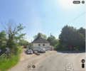
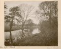
In 1950's I would find my way to R Blythe on two fronts, From Coleshill down Maxstoke Lane to the "lido" at the bottom of the hill by the bend.(picture) And to Packington ford for minnow fishing, using bottles with indented bottoms. Not sure where they came from we certainly didn't have Champagne! What freedom our bikes gave us to roam from the council estate at Garrett's Green
Attachments
Last edited:
Pedrocut
Master Barmmie
Hold our horses !
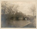
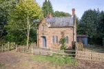
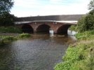
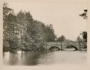
I don’t think that the first bridge (Keeper’s Bridge) is Blythe Bridge which now carries the B4114 Coleshill–Shustoke Road.
There is another picture, Bridge over River Blythe at Shustoke Road, Coleshill, Warwickshire. J.H. Pickard, 1890s.
(Birmingham Archives and Collections)
This has 4 arches and the first picture has three.
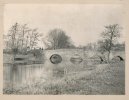
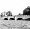
There is a picture here from Geograph…Blyth Hall packhorse bridge, not far away in the Blythe Estate.

 www.geograph.org.uk
I don’t think that the first bridge (Keeper’s Bridge) is Blythe Bridge which now carries the B4114 Coleshill–Shustoke Road.
There is another picture, Bridge over River Blythe at Shustoke Road, Coleshill, Warwickshire. J.H. Pickard, 1890s.
(Birmingham Archives and Collections)
This has 4 arches and the first picture has three.

There is a picture here from Geograph…Blyth Hall packhorse bridge, not far away in the Blythe Estate.

Blyth Hall packhorse bridge © Richard Law cc-by-sa/2.0
Grade II listed https://www.britishlistedbuildings.co.uk/101226397-blyth-hall-packhorse-bridge-over-river-blyth-shustoke#.Wniw19SLTGg in 1988, the main structure of the bridge dates to the 18th century, although the brick parapets and, sadly, the insensitive concrete bridge surface, are 20th...
mw0njm.
A Brummie Dude
what about coleshill bridge
Pedrocut
Master Barmmie
Here is Duke Bridge, (on the Blythe) a little further South on Coleshill Road.

 www.geograph.org.uk

Duke Bridge © Richard Law cc-by-sa/2.0
Shown as Duke Bridge on most maps, but situated at Duke End, this is a Grade II listed structure https://www.britishlistedbuildings.co.uk/101115758-duke-end-bridge-maxstoke#.WVZwC9QrLGg which dates from the 18th century.
Last edited:
mw0njm.
A Brummie Dude
you could be right Janice
The name Keeper's Bridge over the River Blyth in Warwickshire likely comes from a former gamekeeper's cottage or a lock keeper's cottage that was situated near the crossing... there was a few keepers around that erea from packington estate they chased me a few times


The name Keeper's Bridge over the River Blyth in Warwickshire likely comes from a former gamekeeper's cottage or a lock keeper's cottage that was situated near the crossing... there was a few keepers around that erea from packington estate they chased me a few times
Pedrocut
Master Barmmie
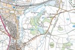
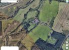
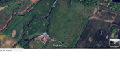
If you look at the modern map and the GE view you will see the Blythe and Cole meet each other some way above Pete’s Keeper’s Cottage near the Old Mill.
Back in 1902 the maps show that the Cole meets the Blythe below the old Mill and then flow on together to join the Tame.
Back in 1902 the maps show that the Cole meets the Blythe below the old Mill and then flow on together to join the Tame.
mw0njm.
A Brummie Dude
The Blythe Mill was a watermill on the River Cole, which is sometimes confused with the River Blythe.
It is located near the current Blythe Mill Farm Supplies company at Blythe Road in Birmingham.
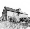
It is located near the current Blythe Mill Farm Supplies company at Blythe Road in Birmingham.
- The original watermill was operational into the 1970s, and parts of its machinery, including an internal undershot wheel, remain.
- The nearby River Cole was diverted in the 1960s, which ended the mill's water-powered operations.
- https://en.wikipedia.org/wiki/River_Blythe

Pedrocut
Master Barmmie
The Blythe Mill was a watermill on the River Cole, which is sometimes confused with the River Blythe.
It is located near the current Blythe Mill Farm Supplies company at Blythe Road in Birmingham.
View attachment 212523
- The original watermill was operational into the 1970s, and parts of its machinery, including an internal undershot wheel, remain.
- The nearby River Cole was diverted in the 1960s, which ended the mill's water-powered operations.
- https://en.wikipedia.org/wiki/River_Blythe
This I think is a confusion of the rivers Cole and Blythe. Blythe Mill was always on the River Blythe according to the old maps. The Cole joined the Blythe below Blythe Mill and added to the flow, and after the Mill the flow continued on to reach the Tame. The Cole’s diversion in the 1960s ended the head-water supply route and because people associated the mill with the Cole corridor through Coleshill.
December 1956 the Coleshill Chronicle is reminiscing on old mills of the area. “Situated on the Blythe, shortly after it received the waters from the Cole was Blythe Mill the premier mill of the district.”
Hams Hall flood alleviation and drainage works in the 60s diverted the Cole and it would meet the Blythe further north.
mw0njm.
A Brummie Dude
The mill's machinery stopped being operational in the early 1960s because the River Cole was diverted, making it impossible to operate the water-powered mechanism. The River Cole itself is a tributary of the River Blythe, with the Cole flowing into the Blythe near Coleshill.
Two water mills were ‘conveyed’ to William Blythe in 1587 and this mill appears to have been part of Blythe Hall estate ever since. Information on ownership exists for the 19th century and 20th century and the building was in use until the 1970s. It is now in use as a store. The mill building is a three storey brick structure with a large lucam. A datestone on the central section reads ‘1754 R & G’. Additions were made in the mid 19th century, notably the full height wheelhouse. The internal undershot wheel, 5.9m in diam, was installed in 1861 by Robert Summers of Tanworth in Arden and much of the machinery remains. In the early 1960s the River Cole was diverted and it became impossible to operate the machinery. Electrical motors were installed.
as far as i know the mill was always on the blythe the cole was a long way from the mill there was a small run off the main river to power a wheel it was there in the 60s overgrown though then it rejoined the main stream and went under the rd to maxtoke
very confusing
Last edited:
Used to live at Maxstoke and had to cross Dukes Bridge to get to Coleshill. Only one bus twice a week so walking 3 miles was often the option as akid. I do have a pic of me perched on the handlebars of my dad's bike on the bridge appx 1954Here is Duke Bridge, (on the Blythe) a little further South on Coleshill Road.

Duke Bridge © Richard Law cc-by-sa/2.0
Shown as Duke Bridge on most maps, but situated at Duke End, this is a Grade II listed structure https://www.britishlistedbuildings.co.uk/101115758-duke-end-bridge-maxstoke#.WVZwC9QrLGg which dates from the 18th century.www.geograph.org.uk
Richard Dye
master brummie
I was wondering that. Are there any weight restrictions on those old bridges?It’s probably got more from India collected by John Benjamin Stone and others.

