• Welcome to this forum . We are a worldwide group with a common interest in Birmingham and its history. While here, please follow a few simple rules. We ask that you respect other members, thank those who have helped you and please keep your contributions on-topic with the thread.

    We do hope you enjoy your visit. BHF Admin Team

Aston Viaduct 1850's

Too far north and too far to the west I think Mike. I think we have got the place and that landscape now would include a derelict car scrap yard and Electric Avenue where I rode my bike. GEC Witton works was to be off to the upper right. Latterly it would be all level and no hill would be experienced but remember the terrain back then, at the time of the painting, would have led down to the water level.
 
I have a paragraph in a book which I am sure other members will also have. It gives a brief description of the Aston area, Would it help if I posted it on this thread?
 
RAILWAYS FOUND THIS ON LINE-----

In 1837 the Grand Junction Railway from Liverpool came through Aston. The route, surveyed by George Stephenson, took advantage of the Tame valley's slight gradient, although this involved several crossings of the meandering river - including two across the great bend near Aston Church. A ten-arched viaduct was built over the two arms and the meadow between. James Watt Junior's objections to the railway may partly explain its route: even so he lost the east end of his prized chestnut avenue from Aston Hall. Within the next decade a cut was made to join the two arms of the river loop on the Witton side. There were low bridges over Witton and Aston Lanes and Lichfield Road, canal and brook: therefrom the great curve of the rails swept down through Nechells and Duddeston to a temporary halt at Vauxhall, thence to Curzon Street terminus in the Rea valley. Astonians wishing to travel on the new-fangled trains to Liverpool or London had to make their way to Curzon Street: from 1842 they could go to Derby and the north-east from Lawley Street terminus. Ten years later Navigation Street (New Street) Station opened in the centre of Birmingham.
In 1854 Aston Station gave local access to the Grand Junction line and New Street: not until 1880 was there a loop line from Aston to Stechford on the London line. Witton Station opened in 1876. Meanwhile Hockley Station (1852) had provided an access point for the Black Country and Oxford lines, and Saltley Station (1854) for the Midland lines to north-east and south-west.
In 1862 the Sutton Coldfield line (later extended to Lichfield) left the Grand Junction south of Aston Hall Road. Both these lines helped to accelerate development of east Aston and south Erdington, as there were sufficient stopping trains to provide a commuters' service. Until the advent of electric tramcars the railways were much used for travel to Aston Hall and Lower Grounds, and to Sutton Park for some decades longer. There were no sidings or railway facilities in the manor, chiefly because the lines were carried on embankments above the Tame floods. 'Aston' Goods Yards were in Duddeston, and those near Witton Station were in Handsworth.


Previous
Next
 
All superb maps, I think Rupert has the viewpoint, as the railway crosses the river twice, but Mikes map than shows the diverted river to run alongside the embankment - Make a lot of sense now!
With the Lichfield line being a later extension, the original drawing has a clearer view without the later viaducts.

Congratulatuions on such research - brilliant
 
I think this must be the lost image being discussed on this thread. So would the building on the bridge have been a mill ? And what would the building be to the furthest left ? According to the earlier discussion, the farmer in the foreground is herding the animals down the later Holborn Hill.

Screenshot_20250627_140418_Chrome.jpg
 
Last edited:
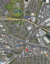
Yes Mort, then Aston Church to the right. I think the mill/farm building to the right of the viaduct must have been between Lichfield Road and Long Acre (estimated at red pointer, or even a little further north towards Thimble Mill Lane, but this is just an estimate). The building has Dutch gables and I wondered if, at one time, it was associated with Aston Hall. Here's a modern-day map. An early map might help to pinpoint the farm building.
Screenshot_20250704_125227_Maps.jpg
 
Last edited:
Back
Top