-
Welcome to this forum . We are a worldwide group with a common interest in Birmingham and its history. While here, please follow a few simple rules. We ask that you respect other members, thank those who have helped you and please keep your contributions on-topic with the thread.
We do hope you enjoy your visit. BHF Admin Team
You are using an out of date browser. It may not display this or other websites correctly.
You should upgrade or use an alternative browser.
You should upgrade or use an alternative browser.
St Martins Row
- Thread starter Astoness
- Start date


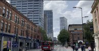
thanks tinpot it looks like you are spot on as we can clearly see the same line of shops in my photo...so this confirms the location of the photo is st martins row...st view below ...i just dont recognise broad street now
lyn

lyn
Last edited:
Don't know the date of this map (posted by the late Dennis Williams in the "Passageways .." thread), but St Martin's Row isn't marked, only St Martin's Place is marked, (although there is the narrow section leading from it)
Dennis Willians posted a few photos taken from where the 'row' joins Broad Street, the row being to the right of the Antiques shop. (Bought a few pieces of furniture from there when stripped pine was all the rage).


This photo below was posted by Postie on the St Peters Row thread, showing a bit more of the view along St Martin's Row from the Briad Street end looking towards St Peters spire (right of the antique shop).

Dennis Willians posted a few photos taken from where the 'row' joins Broad Street, the row being to the right of the Antiques shop. (Bought a few pieces of furniture from there when stripped pine was all the rage).
This photo below was posted by Postie on the St Peters Row thread, showing a bit more of the view along St Martin's Row from the Briad Street end looking towards St Peters spire (right of the antique shop).
Last edited:
btrackbuilder
New Member
This is fantastic, I was born at No 7 StMartin’s Row in March 1948 and moved to Bartley Green in March 1951. I’ve been searching for information for a long time, so this is pegect. Thank you