-
Welcome to this forum . We are a worldwide group with a common interest in Birmingham and its history. While here, please follow a few simple rules. We ask that you respect other members, thank those who have helped you and please keep your contributions on-topic with the thread.
We do hope you enjoy your visit. BHF Admin Team
You are using an out of date browser. It may not display this or other websites correctly.
You should upgrade or use an alternative browser.
You should upgrade or use an alternative browser.
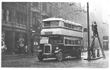
Where is this vehicle ?
- Thread starter Vivienne14
- Start date
Janet Hunt
master brummie
Definitely looks like Corporation Street to me New Street End
Radiorails
master brummie
It is Corporation Street and the trolleybus is about to enter Corporation Place. Apparently it is 1932. Corporation Place was rebuilt in 1933. The trolleybus is only a few weeks old is on its way to Nechells via Gosta Green. OV 4011 - fleet no.11.
The workmen, on the right, are apparently cleaning a large street lamp.
There is also a window cleaner, on his ladder, at the left of the photo.
The workmen, on the right, are apparently cleaning a large street lamp.
There is also a window cleaner, on his ladder, at the left of the photo.
Radiorails
master brummie
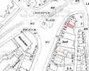
Lancaster Place has name changes it seems over the years. It seems it was known as Corporation Place before the early 1930's remodelling and demolitions then becoming Lancaster Place. It is known as Lancaster Circus now (unless it has another rename). 
Thanks all. Viv.
Lloyd
master brummie
The city terminus for this service was Old Square, with two-way running in Corporation Sttreet to there from Lancaster Place. The trolleybuses were garaged at Washwood Heath depot, and access to & fro was with one pole up on the tram wire, and a chain hooked on the chassis trailling in the tram track for the return current. There were technical reasons the double wires could not be erected to the depot.
About here- (see link) - you can see the tower of Central Hall and the distinctive domed turret on one corner of the building in the photo.

 www.google.co.uk
Google Maps
Find local businesses, view maps and get driving directions in Google Maps.
 www.google.co.uk
Mickymoo
master brummie
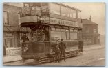
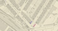
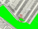
I think it's Waverley Road terminus,with Oldknow Road going to the left,behind it...Map here showing location...Another tram in an unknown place. From a Facebook site devoted tom identifying old photographs. A postcard pre WW1 of tram Station St to Bolton road at an unknown position
View attachment 194652
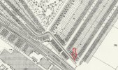
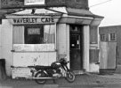
The corner shop maybe Bagley, possibly something J Bagley ?
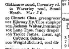
maybe someone could look in kellys for the shop name bagley
lyn
I think it's Waverley Road terminus,with Oldknow Road going to the left,behind it...Map here showing location...
View attachment 194656
could be right there...if you look closely through the tram window it looks like there is a corner shop which says on the window of the shop oldknow stores sells aston ales so possibly an outdoor so a kellys look up for oldknow stores should solve the location of the tram..
lyn
pjmburns
master brummie
in 1915 Samuel Bagley is listed at 68 Waverley Road as a boot maker .
Last edited:
Radiorails
master brummie
I suggest it is at the terminus at Waverley. Road. Tram route B soon to be numbered to 22. It was discontinues in 1930, briefly replaced by single deck Guy buses and then became the roundabout route 28. The tram was originally open topped, soon got a top cover entering service in 1906 at Roseberry Street and was sent to Cashmores, Great Bridge, for scrapping in 1937. Pre wW1 is about right..
Last edited:
interesting mike thanks
lyn

