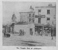
-
Welcome to this forum . We are a worldwide group with a common interest in Birmingham and its history. While here, please follow a few simple rules. We ask that you respect other members, thank those who have helped you and please keep your contributions on-topic with the thread.
We do hope you enjoy your visit. BHF Admin Team
You are using an out of date browser. It may not display this or other websites correctly.
You should upgrade or use an alternative browser.
You should upgrade or use an alternative browser.
Temple Row
- Thread starter historicaldennis
- Start date
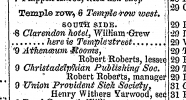
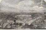
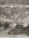
This engraving has been on the Forum before, but I’ve never noticed the Atheneum on Temple Row shown in the enlarged image. This seems to have been used for various purposes over time such as meetings, sales and auctions and may have also had offices associated with it for insurance administration. The earliest reference I’ve found is 1855, but it may date to an earlier time. It still existed (in the name of the Atheneum) in the 1880s. Can anyone pinpoint the road at the junction where the Atheneum stands at Temple Row ?
The second thing I’ve since noticed are the tightly packed tombstones in St Phillip’s Churchyard. Viv.
The second thing I’ve since noticed are the tightly packed tombstones in St Phillip’s Churchyard. Viv.


Well they did managed to pack 80,000 burials into St PhillipsThis engraving has been on the Forum before, but I’ve never noticed the Atheneum on Temple Row shown in the enlarged image. This seems to have been used for various purposes over time such as meetings, sales and auctions and may have also had offices associated with it for insurance administration. The earliest reference I’ve found is 1855, but it may date to an earlier time. It still existed (in the name of the Atheneum) in the 1880s. Can anyone pinpoint the road at the junction where the Atheneum stands at Temple Row ?
The second thing I’ve since noticed are the tightly packed tombstones in St Phillip’s Churchyard. Viv.
View attachment 160160
View attachment 160159
Richard Dye
master brummie
ELL, just looked at ALL of your pictures! Rally very very impressive. Gave each better understanding of somewhere I have not been in a long time. Thank you!I've got quite a lot of Temple Row photos.
Here are some
Former Birmingham Midshires bank (now Caffe Nero)
Caffe Nero - Temple Row West (former Birmingham Midshires) by ell brown, on Flickr
Pevsner Architectural Guides: Birmingham by Andy Foster
Great Western Arcade
Great Western Arcade - from Temple Row by ell brown, on Flickr
Richard Dye
master brummie
Beautiful work!This engraving has been on the Forum before, but I’ve never noticed the Atheneum on Temple Row shown in the enlarged image. This seems to have been used for various purposes over time such as meetings, sales and auctions and may have also had offices associated with it for insurance administration. The earliest reference I’ve found is 1855, but it may date to an earlier time. It still existed (in the name of the Atheneum) in the 1880s. Can anyone pinpoint the road at the junction where the Atheneum stands at Temple Row ?
The second thing I’ve since noticed are the tightly packed tombstones in St Phillip’s Churchyard. Viv.
View attachment 160160
View attachment 160159
DavidGrain
master brummie
Mr Wilkinson and Mr Riddell and other images from a booklet celebrating the opening of a new wing in 1925. The address is given 42 Cherry Street, but that may have been an admin address. Not sure. Viv.View attachment 160823
Wilkinson and Riddell
of 42 Cherry Street, Birmingham.
- 1892 The company was registered on 12 February, to acquire the business of the firm of the same name, textile merchants and manufacturers.
historicaldennis
knowlegable brummie
PMr Wilkinson and Mr Riddell and other images from a booklet celebrating the opening of a new wing in 1925. The address is given 42 Cherry Street, but that may have been an admin address. Not sure. Viv.View attachment 160823View attachment 160824View attachment 160825View attachment 160826View attachment 160827
I see you are one of the main contributors to this forum for Temple Row Vivienne, and I am the gentleman who first started this forum 10 years ago, and having recently returned to live back in Birmingham, I thought I would check how the forum was going, and so pleased to see that an interest is still being shown, although very little now about Temple Row itself, but still good to see how it’s developed over the 10 years since I started it. I hope to start writing again about my history at Temple Row, just got to get new thoughts into my head ready for you all, so although I have read most of the recent contributions, I just want to read more so I can see how it’s getting on, but thank you to all of you who have kept things going, well done.Mr Wilkinson and Mr Riddell and other images from a booklet celebrating the opening of a new wing in 1925. The address is given 42 Cherry Street, but that may have been an admin address. Not sure. Viv.View attachment 160823View attachment 160824View attachment 160825View attachment 160826View attachment 160827
How lovely ! It’d be great to hear more about Temple Row and, in fact, any other Birmingham details when you have time. Didn’t that 10 years fly by ?!
Thank you.
Viv.
Thank you.
Viv.
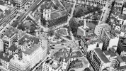
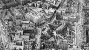
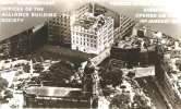
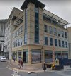
This 1953 aerial view shows a new building on Temple Row (think it’s at the junction with Temple Street). If so the building must be today’s ‘The Ivy’ at #67 Temple Row. The building in the image seems to have been superimposed and it also seems to have undergone changes today. But I feel fairly confident it’s the same building there today. Viv.
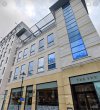 Source: Google Streetview

 Source: Google Streetview
devonjim
master brummie
A bit of a delay but found this full frontal of "The Clarendon" on facebook.
View attachment 125128
Personal interest as my dad was "gaffer" there when it closed early 1960's. Don't think it was an Ansell's house by that time. Think it was a "free" house belonging to the same company that owned "The George in the Tree" on the road to Kenilworth from Stonebridge.
The Clarendon was just across the road from this proposed new building.This 1953 aerial view shows a new building on Temple Row (think it’s at the junction with Temple Street). If so the building must be today’s ‘The Ivy’ at #67 Temple Row. The building in the image seems to have been superimposed and it also seems to have undergone changes today. But I feel fairly confident it’s the same building there today. Viv.
View attachment 168116
View attachment 168117Source: Google Streetview
Eric Gibson
master brummie
Had my mortgage from the Alliance in 1956, used to call in there monthly to pay in cash. That was in Colmore Row I thought.
paul stacey
master brummie
great article Viv, so interesting..
Samuel Lines must have found this part of Birmingham interesting, not only did he live nearby on Temple Row West, there are a number of his drawings of this part of Birmingham.
Maybe they were done as part of his teaching at his drawing school in Temple Row West ? For whatever reason, they’ve captured the roads before redevelopment. The road off to the right is Temple Street and you can see how the low level building just in view is in a very poor state of repair. I notice the Churchyard is walled too.
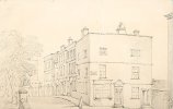
The same scene today, around 200 years later. Viv.
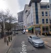
Maybe they were done as part of his teaching at his drawing school in Temple Row West ? For whatever reason, they’ve captured the roads before redevelopment. The road off to the right is Temple Street and you can see how the low level building just in view is in a very poor state of repair. I notice the Churchyard is walled too.

The same scene today, around 200 years later. Viv.

Richard Dye
master brummie
I see that strip of cobble stone!Samuel Lines must have found this part of Birmingham interesting, not only did he live nearby on Temple Row West, there are a number of his drawings of this part of Birmingham.
Maybe they were done as part of his teaching at his drawing school in Temple Row West ? For whatever reason, they’ve captured the roads before redevelopment. The road off to the right is Temple Street and you can see how the low level building just in view is in a very poor state of repair. I notice the Churchyard is walled too.
View attachment 176782
The same scene today, around 200 years later. Viv.
View attachment 176783
DavidGrain
master brummie
That is a rumble strip to warn car drivers that they are entering a restricted area.I see that strip of cobble stone!
Janet Hunt
master brummie
David is correct found this old picture on Alamy another samuel Lines drawing of the demolision of the houses to cut in Waterloo StreetThat now makes sense David. I'd looked at an old map and Waterloo Street seemed to me to be at the wrong angle to feature in Samuel Lines's painting. So that's cleared that one up for me, thanks. Looking a bit more at the painting, there's a wall going around St. Phillip's churchyard. Seems unimaginable now as in my memory it's always been iron railings. Viv.

Temple Row Old Houses Taken Down, May 1823 for the opening to Waterloo Street, Birmingham By Samuel Rostill Lines Topographical Views Lines Family Collection, Drawing, Pencil, Topographical Views, Birmingham history, England, Midlands Stock Photo - A
Download this stock image: Temple Row Old Houses Taken Down, May 1823 for the opening to Waterloo Street, Birmingham By Samuel Rostill Lines Topographical Views Lines Family Collection, Drawing, Pencil, Topographical Views, Birmingham history, England, Midlands - 2DDJ08E from Alamy's library of...
And the view today
Janet Hunt
master brummie
Viv, it appears Samuel Lines was a very forward thinking person and documented the area as best he could in times that were changing quickly, just like the historical photographers who's photographs we enjoy on the forum everyday.Samuel Lines must have found this part of Birmingham interesting, not only did he live nearby on Temple Row West, there are a number of his drawings of this part of Birmingham.
Maybe they were done as part of his teaching at his drawing school in Temple Row West ? For whatever reason, they’ve captured the roads before redevelopment. The road off to the right is Temple Street and you can see how the low level building just in view is in a very poor state of repair. I notice the Churchyard is walled too.
View attachment 176782
The same scene today, around 200 years later. Viv.
View attachment 176783
Well done Samuel! that's all I can say
Absolutely Janet. The other benefit from Lines’s paintings and drawings is the smaller details he also provided. Has helped us in all sorts of ways 200 years on. Very perceptive artist. Viv.
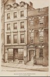
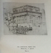
Would the Athenaeum have been at the junction of Temple Row and Temple Street or further along going towards Bull Street ? I think this building has been mentioned before but not sure where. It was once occupied by the Royal Birmingham Society of Artists. That must have been before moving to New Street. This drawing was from the History of the Royal Birmingham Society of Artists by Joseph Hill and William Midgely.
A bit about Jelley
James Valentine Jelley (1856–1950) was an English artist who was an employee of the Birmingham School of Art and a member of the Royal Birmingham Society of Artists and served as its president from 1932 to 1935.
Viv.
A bit about Jelley
James Valentine Jelley (1856–1950) was an English artist who was an employee of the Birmingham School of Art and a member of the Royal Birmingham Society of Artists and served as its president from 1932 to 1935.
Viv.


Last edited:
paul stacey
master brummie
Quite fantastic, the change over the last 100 years in Birmingham, Viv, we have lost so many fine buildings, and with that goes am awful lot of history. Course change dos happen, but poor old Brum seems to have suffered more than most major city's, so glad we have this site to record it all !!


