-
Welcome to this forum . We are a worldwide group with a common interest in Birmingham and its history. While here, please follow a few simple rules. We ask that you respect other members, thank those who have helped you and please keep your contributions on-topic with the thread.
We do hope you enjoy your visit. BHF Admin Team -
HI folks the server that hosts the site completely died including the Hdd's and backups.
Luckily i create an offsite backup once a week! this has now been restored so we have lost a few days posts.
im still fixing things at the moment so bear with me and im still working on all images 90% are fine the others im working on now
we are now using a backup solution
You are using an out of date browser. It may not display this or other websites correctly.
You should upgrade or use an alternative browser.
You should upgrade or use an alternative browser.
Wenman street
- Thread starter jacko
- Start date
Phil
Gone, but not forgotten.
Hi Jacko
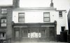
These are two of the photos of Wenman Street that I have. One of the Crown public house and the other is the Gospel hall on the corner of Knutsford St that was next to the bomb site where we all used to do our winter sledging on makeshift sledges.
Phil
These are two of the photos of Wenman Street that I have. One of the Crown public house and the other is the Gospel hall on the corner of Knutsford St that was next to the bomb site where we all used to do our winter sledging on makeshift sledges.
Phil
Attachments
TOPSYTURVEY
brum
Back yards 1960s

Phil
Gone, but not forgotten.
Hi Topsyturvy,
Your back yards photo from the 1960's looks suspiciously like Mount Pleasant Terrace to me. which was a very steeply inclined downhill terrace that ran down between the Crown public house and Green's greengrocers shop. It was known to some as The Glory Hole and was also home to the little old lady that sold "Handy Carriers" in the Bull Ring.
Phil
TOPSYTURVEY
brum
Thanks Phil. I didn,t know the area at all. Can,t always guarantee whether the location that goes with the pics is correct until someone that knows points it out.
Hi Jacko,
My parents grew up in Balsall Heath, my mother in Arter St and my father in Balsall Heath Rd. They were married in the Wenman St Gospel Hall in 1935 and lived in Sparkhill where I was born, however they continued as members the Gospel Hall and my sister and I went there with them right up until it closed on 30[SUP]th[/SUP] January 1966.
I took the photo of Wenman St Gospel Hall which Phil put up; in 1964 the mini out front was mine. I too played on the bomb site with friends after the evening service, and got into trouble from my parents for damaging my best shoes.
I could be wrong, but I don’t think the ‘Back yards’ is the Glory Hole, which I knew quite well. The one gas lamp was in the centre of the one central path. I with friends from the Hall have sung carols in the snow by the light of the gas lamp which a group of people could all stand around.
Brian
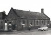
Hi Jacko,
The Wenman St houses across the street from the Gospel Hall. These photos were taken at a members 21[SUP]st[/SUP] Birthday Party held in the Hall about 1960.
A Mr & Mrs Cooper who had two sons David and Roger lived in the house on the left. The word ending in ‘TS’ was either Bycrofts or Bancrofts, I think, it was a haulage company for wich Mr Cooper worked.


Brian
The Wenman St houses across the street from the Gospel Hall. These photos were taken at a members 21[SUP]st[/SUP] Birthday Party held in the Hall about 1960.
A Mr & Mrs Cooper who had two sons David and Roger lived in the house on the left. The word ending in ‘TS’ was either Bycrofts or Bancrofts, I think, it was a haulage company for wich Mr Cooper worked.
Brian
Phil
Gone, but not forgotten.
Hi Brian,
Have we spoke before on another forum? As it's strange that I would end up with a photo you have taken, unless you have put it about a bit. I'm an avid collector and I pick up photos from all over the place.
As for Mount Terrace I only say Jacko's photo looks like it, as the very few times I ever went down there would not make me an expert, but seeing as it looks definitely like a downhill terrace and we are looking toward the bottom of the terrace I think it rules Brighton & Islington terraces out on the other side of the road. The only other terraces I can think of on the same side as the Glory Hole were Pearson Place and Winifred Grove, do you think it could be one of them?
Phil
Dear Phil,
I put my photo on Old Birmingham Pictures, I am happy you are interested in it. Definitely not Islington Terr, Brighton Terr and Winifred Grove ring a bell, but I cannot place them in my mind, recall a Pearson Street on the same side as the Glory Hole, an Albert and Elsie Bennet members of the Gospel Hall lived at No.3. The photo definitely is not Pearson St. Was there a Pearson Place as well? I have only been back to Wenman St once in the last 40 years, so the memory fails in places. My Great Aunt lived in Mary Street right at the back of the Glory Hole.
Brian
Phil
Gone, but not forgotten.
Hi Brian
I think Pearson Place would have been close to Pearson St. On the map I think it would have been the short terrace that backed on to Harry Monty's dress factory on Alliance Place off Mary Street. The entrance would have been opposite St Johns Church Hall, where those of us who went to St Johns School had our school, dinner every day.
Phil
Attachments
charliewag
knowlegable brummie
Hi Phil,
I don't think it was Winifred Grove, the houses in Winifred Grove baked on to my in-laws yard, their entry was opposite Hampden Street, the entry was a very narrow entry of blue bricks lethal in the winter, opened out after about 20 yards in the first house live Jim Taylor and his family,brother to Bert Taylor the ex boxer, then it opened out with gardens and at the bottom of the yard where 2 small cottage type properties with a brew house a toilet and 2 dustbins standing out in the open, handy to step on, to hop over the wall to the passage that led to Mary Street.
attached 3 pictures 1.boards dividing Winifred Grove and their entry. 2.outside No.4 Winifred Grove. 3. brew house and toilet.
charliewag
knowlegable brummie
Sorry Phil made a bit of a hash

Phil
Gone, but not forgotten.
Charliewag
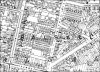
So Pearson Terrace must have been the other terrace that backed on to Alliance place a bit further down the road and perhaps the smaller one wasn't named as the only names I can find on the west side of Wenman Street are,
Mount Pleasant Terrace (sometimes just called Mount terrace)
Winifred Grove
Pearson Place.
On the other side of the road were,
Hartland Gardens
Brighton Terrace
Islington Terrace
That is of course unless anybody can add to those named.
Phil
Jacko,
This is inside Wenman St Gospel Hall at the Winter Sunday School Party January 1964.
Do you or does anyone recognise themselves?

Adults at back Mrs Rose Essery (My Mum,) Mr Tamplin, Mr Edward Essery (My Dad.)


Left to right Mr Dan and Mrs Joyce Thomas, Mr and Mrs Tamplin, Girl1, Girl2, Wendy Thomas.
Brian
This is inside Wenman St Gospel Hall at the Winter Sunday School Party January 1964.
Do you or does anyone recognise themselves?
Adults at back Mrs Rose Essery (My Mum,) Mr Tamplin, Mr Edward Essery (My Dad.)
Left to right Mr Dan and Mrs Joyce Thomas, Mr and Mrs Tamplin, Girl1, Girl2, Wendy Thomas.
Brian


Have looked at the electoral rolls, adn the large scale maps, but haven't found any terraces on the west side that are not listed in post 21, except for St augustine terrace, which was a bit different, as it was on the road. Have coloured terraces as below
On west side:
Turquoise St Augustine place
Red Mount Terrace
Blue Pearson Place
Green Winifred Grove
On east Side:
Green Brighton Terrace
Blue Dudley Place
Red Hartland Place
Turquoise Islington Terrace
Orange Hamden Place (not Wenman St actually but close)

On west side:
Turquoise St Augustine place
Red Mount Terrace
Blue Pearson Place
Green Winifred Grove
On east Side:
Green Brighton Terrace
Blue Dudley Place
Red Hartland Place
Turquoise Islington Terrace
Orange Hamden Place (not Wenman St actually but close)
petewhitemdr1
brickie brummie
i remember that hall well, and the nuns. went to st johns school from 64 till 66 when we were moved out for the slum clearance. the nuns terrified me at the time
TOPSYTURVEY
brum
Short vieo clip might be of interest. MACE The Media Archive for Central England | Media clip[Midlands News: 17.04.1962: Balsall Heath Youth Club]