Alf Rogers
master brummie
Really appreciating your side-by-side comparison photos, Brummy Lad! Wonderful, thank you!


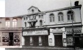
I thought it was 1965?The third picture showing the Palace advertises From Russia with Love which was advertised in February 1972.
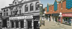
What we call: “snatching defeat from the jaws of victory” particularly photo 1.Erdington High Street..... Then & Now....
Photo 1 - My Great Grandparents outside their Central Cafe, from around 1906'ish.... Alongside what's there now... Ugh!
The cafe was originally next door to the Palace Theatre (later to become the Palace Cinema) on the High Street.
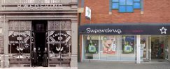
Photo 2 - Shows what replaced the 'Palace'.
Photo 3 - Is a mock-up to show where the cafe was in relation to the 'Palace'.
Article from Birmingham Gazette January 1941, with present Google Earth view.
“The city possesses one of the best designed nursery schools in the country.”
One of the most striking nursery schools in the country is Brearley-street Nursery School, Birmingham. It is U-shaped, and all its classrooms have a sunny aspect. Children are seen getting on a friendly footing with old friends on the first day of the new term.
View attachment 191142
View attachment 191143View attachment 191144View attachment 191145
View attachment 191146
My how it has changed. Thanks for posting.Joining two photos together, I made this panoramic photo of Salters hardware shop which was situated on the corner of Gerrard St & Wheeler St Lozells. Also, using Google Earth, what that location looks like today.
View attachment 193263
I recall the MUSIC BOX at the Six Ways end of High Street,m where I used to buy all my 78" records. I loved the place. Anyone remember it?What we call: “snatching defeat from the jaws of victory” particularly photo 1.
Thank you!
This has been tried here a couple of times previously, but it seems most of the photos were lost when the site was hacked. As I have previously done this sort of thing elsewhere and I have some fifty or sixty photos I thought I would post them here. If you have any photos of a similar nature or some of those that were posted previously then please join in.
I suppose there is no better place to start than the Bullring through the years, this is something that I hurriedly knocked up some years back to illustrate something on another site. I think it is pretty amateurish, but obviously the council didn't think so because they nicked it for one of their webpages. The second photo shows the Bull that adorned the façade over the Queensway.
I remember booking my passage to the US and reading those signs as i walked into the travel agent to make sure they had boats going from Southampton to New York & yes I came steerage,I love the old shipping line destinations in the windows of the building on the right!
Ah, memories galore! I booked my own passage with Ellis Travel Agency and sailed for New York on March 12th, 1958, arriving on St. Patrick's Day. I went steerage too - my cabin was D179, four decks down on the RMS Queen Elizabeth.I remember booking my passage to the US and reading those signs as i walked into the travel agent to make sure they had boats going from Southampton to New York & yes I came steerage,
I’m a little later: Sailed November 10, 1962 arriving New York November 15 1962 after a very rough night at sea on the SS United States. I still have still have slides that I took of the Statue of Liberty as we sailed up the Hudson River.Ah, memories galore! I booked my own passage with Ellis Travel Agency and sailed for New York on March 12th, 1958, arriving on St. Patrick's Day. I went steerage too - my cabin was D179, four decks down on the RMS Queen Elizabeth.
Doctor mcgregor was our family doctorAt the other end of Balsall Heath at the junction of Gooch Street and Conybere Street looking toward William Edward Street with Dr MacGregors surgery on the corner.
View attachment 135682