-
Welcome to this forum . We are a worldwide group with a common interest in Birmingham and its history. While here, please follow a few simple rules. We ask that you respect other members, thank those who have helped you and please keep your contributions on-topic with the thread.
We do hope you enjoy your visit. BHF Admin Team
You are using an out of date browser. It may not display this or other websites correctly.
You should upgrade or use an alternative browser.
You should upgrade or use an alternative browser.
Then & Now
- Thread starter Phil
- Start date

A WOODHALL
knowlegable brummie
I lived Handsworth Wood, Beechglade parents had record shop on College Road.We lived in Handsworth Wood, I remember the village shops in the 80's very well")


paul stacey
master brummie
Hagley Road now a duel carriage way , Blimey!!


poker_pete82
master brummie
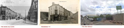
The lack of change is impressive.. and still called Stans Cafe!View attachment 181933
Stan's Cafe, Headinglev Road, Handsworth. 10th lulv 1967. (Birmingham at work by Douglas, Alton. Publication date 1993)
And Google image shows just a few changes 50 odd years later ! Looks like you could leave your bike outside in them days ?
View attachment 181934
paul stacey
master brummie
Yes, sad, but time moves on, as do we all !!!


You can now sit at a table outside the former Bob's Cafe. We wouldn't have dreamed of sitting at a table on the pavement in the 1950s ! I can't remember being able to do that anywhere. The closest would have been Gino's above New Street Station, but even that was covered in.
Viv
Viv
mikeconcannon
Brummie babby
Thank you Old Mohawk for posting the old picture of Garrison Lane, we lived at 302 Garrison lane, the row of houses on the right hand side of the picture, I have been looking for years for a picture like this, I notice that the houses that were bombed during the war, three houses up the road from us, are still standing in this photo. The Dump is shown in all its glory, I have tried to explain to people how we had a three dimensional play ground to explore, like our own Smokey Mountain (Manilla), right in our back yard. The dump was probably still in commercial use at the time the photo was taken because it looks fairly neat and not all overgrown with vegetation, and not an industrial dumping site yet.In 1934 a small aeroplane flew over Small Heath with the observer leaning out of the open cockpit to photograph the Whitworth Motor Accessories factory with nearby roads also in the view.
Red dot - Lime Grove
Green dot - Tilton Road
Blue dot - Venetia Road
View attachment 161635
image source 'https://www.britainfromabove.org.uk/'
In 2020 a Google Earth view shows that 13 bays of the Whitworth factory building still exist as does the school building (minus it's spire) seen in the 1934 view near the corner of Tilton Road and Garrison Lane. The white building next to the school is now used as a mosque. Lime Grove has been replaced by a car park but Venetia Road is still there minus houses. I suppose the folk of 1934 would have been surprised to be told that sometime in the future an 'HMS Forward' would appear in the area.
View attachment 161636
Click and scroll to see HMS Forward ....

")

You wouldn't know if there is a view showing the fronts of Garrison Lane houses? was there a series of these pictures taken at the time.
Cheers, mike Galway, Ireland
devonjim
master brummie
There's quite a few pictures in this sequence, I've roughly worked out where No302 would have been and I think this is the nearest I can get, mind you many others are better at manipulating these things!Thank you Old Mohawk for posting the old picture of Garrison Lane, we lived at 302 Garrison lane, the row of houses on the right hand side of the picture, I have been looking for years for a picture like this, I notice that the houses that were bombed during the war, three houses up the road from us, are still standing in this photo. The Dump is shown in all its glory, I have tried to explain to people how we had a three dimensional play ground to explore, like our own Smokey Mountain (Manilla), right in our back yard. The dump was probably still in commercial use at the time the photo was taken because it looks fairly neat and not all overgrown with vegetation, and not an industrial dumping site yet.
You wouldn't know if there is a view showing the fronts of Garrison Lane houses? was there a series of these pictures taken at the time.
Cheers, mike Galway, Ireland
Attachments


Pedrocut
Master Barmmie
“The view along Stratford Road from the tower of St Agatha's Church in around 1903 shows the steam tram tracks disappearing towards the Mermaid Public House at the junction with Warwick Road. On the right is the area around Stoney Lane. In the section of Stratford Road beyond the Baptist church built in 1879 on the corner of Palmerston Road is a CBT steam tram and trailer that is approaching the junction at Walford Road on its way to Sparkhill. By this date, Sparkbrook, although still in the Parish of Yardley UDC, was virtually complete as a suburb, with only a few side roads waiting for the construction of the then-normal tunnel-back housing.“
(Commercial postcard)

The 1903 view alongside the revised 1903 OS Map.

The Google 3D view

(Commercial postcard)
The 1903 view alongside the revised 1903 OS Map.
The Google 3D view


Richard Dye
master brummie
Luckily it was a nice wide road, it would be 8n passable today!
What are Model by-law houses? Not heard that before.
Richard Dye
master brummie
mw0njm.
A Brummie Dude
Pre-regulation terraced houses in the United Kingdom - Wikipedia
Richard Dye
master brummie

Byelaw terraced house - Wikipedia
en.wikipedia.org

mw0njm.
A Brummie Dude
Dionysius//88
master brummie
Spent a few dinner times in there when I worked in George St great pint of Brew X1New windows and light fixture, shame looked like a nice pub!


flossiefoster
master brummie
I think that the old Deritend and Digbeth would have been vastly more interesting than they are at the moment but probably rather risky too!Hello everyone, here is the latest video of Bham Past & Present that I did, around High St Deritend. Thank you for your help finding the location of some of these photos.
Deritend Past & Present pt 2/3
Thanks for the lovely photos.
Richard Dye
master brummie
That was a pretty good brew as I recall!Spent a few dinner times in there when I worked in George St great pint of Brew X1