• Welcome to this forum . We are a worldwide group with a common interest in Birmingham and its history. While here, please follow a few simple rules. We ask that you respect other members, thank those who have helped you and please keep your contributions on-topic with the thread.

    We do hope you enjoy your visit. BHF Admin Team

St Philips Tavern, Church Street.

MikeP

master brummie
I am doing some research on a mysterious Great Grandfather of mine who went by the name of Henry Edward Hicks. He was born in Paddington, London abt. 1851 and it appears that Henry was orphaned, a foundling, given away or of a single mother but of unknown parents.

I am doing some research on a mysterious Great Grandfather of mine who went by the name of Henry Edward Hicks. He was born in Paddington, London abt. 1851 and it appears that he was orphaned, a foundling, given away or of a single mother but of unknown parents.

He turns up in Aston in 1861 living in Park Road with a Henry Whitworth and a Hannah along with other children from Henry Whitworth's first marriage to a Kezia Slade who died in 1860 (Hannah and Henry are not known to have married). Later in 1871 he was living at 11 Portland Street, Aston with Hannah and Henry. Through DNA testing I believe I have found his father but his mother is elusive. She could potentially be the Hannah mentioned above believed to have been born in Ross Herefordshire.

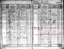
Henry and Hannah were of the same age throughout the later census records. Looking at an earlier 1841 census (see attached) there is a Henry Whitworth and a Hannah Howell(s) (same age) staying at St Philips Tavern, in Church Street off Colmore Row. She was a visitor born 'out of county' and Henry looks like a Brass Founder, sort of consistent with his later occupation. Based on the 1841 Census this Tavern was 34 Church Street but I have never been able to find any information on a St Philips Tavern anywhere.

I believe that this Hannah could have been my G. Grandfathers mother and that she knew or met Henry before he married Kesia, then when Kezia died was back on the scene with a son.

The early maps I have only have one public house now called Royal Oak on the corner of Church Street and Cromwell Street of the right era and Hotel looking. But according to Google maps it is about 44 Church Street. 34 Church Street would be somewhere around / next to what was the Grand Hotel but now looks like offices or on the other side of the road.

So my question to this Forum and pub historians is, has anyone heard of or know of or has any information on this at St Philips Tavern?

Any assistance would be greatly appreciated :).

Mike
 

Attachments

  • 1841_Census_StPhilips_TavernC.jpg
    1841_Census_StPhilips_TavernC.jpg
    567.9 KB · Views: 7
hi mike i have no doubt that the pub existed...church st is still there off colmore row but the old buildings were demolished probably a 100 years ago..i know somewhere on the forum are a couple of old photos of the old church st but not sure what thread they are posted on but i will try and find them for you...hopefully some of our members can check the kellys directories for you...

lyn
Thanks Lyn, I made a error in my post that I could't edit later but I should have said it was probably somewhere between Edmund Street and Cromwell Street, if the house numbers are still about the same it is not near the Grand hotel which is still there. Does anyone have house numbers for Church Street?
 
Thanks Lyn, I made a error in my post that I could't edit later but I should have said it was probably somewhere between Edmund Street and Cromwell Street, if the house numbers are still about the same it is not near the Grand hotel which is still there. Does anyone have house numbers for Church Street?
mike as you know there was no numbering in 1841...i think its best to wait until hopefully some of our other members who are better than i am spots your post i am sure you will get some answers in the meantime i will continue to search for any old photos of church st although they may not show much

lyn
 
The St Phillipd Tavern is listed as at 35 (not34) Church St in directories dated 1841 to 1876, but had disappeared by the 1878 edition. (Date is publication date and may refer to year before, or possibly earlier). The numbering changed in the mid 1880s, but the tavern was definitely on the north east side of the street, between what is now Colmore Row and Barwick St and probably in the position on the corner, as shown in red on the 1880s map

map 1880s showing probable position of St Phillips Tavern up till 1870s.jpg
 
The St Phillipd Tavern is listed as at 35 (not34) Church St in directories dated 1841 to 1876, but had disappeared by the 1878 edition. (Date is publication date and may refer to year before, or possibly earlier). The numbering changed in the mid 1880s, but the tavern was definitely on the north east side of the street, between what is now Colmore Row and Barwick St and probably in the position on the corner, as shown in red on the 1880s map

View attachment 188940
WOW thanks Mike, much appreciated.
 
so from mikes map the pub would have been on the corner of barwick st and church st...street view below i have also been in touch with a couple of contacts to see if they have any photos of the old street or the pub...long shot but if you dont ask you dont get as our dad used to say..if any do turn up i will post them on this thread


Last edited:
The St Phillipd Tavern is listed as at 35 (not34) Church St in directories dated 1841 to 1876, but had disappeared by the 1878 edition. (Date is publication date and may refer to year before, or possibly earlier). The numbering changed in the mid 1880s, but the tavern was definitely on the north east side of the street, between what is now Colmore Row and Barwick St and probably in the position on the corner, as shown in red on the 1880s map

View attachment 188940
mike could you find out where the red lion was in church st please and highlight it on the map...date would be 1886 looks like A nicholas as landlord and it is on a corner but which corner...thanks mike

lyn
 
so from mikes map the pub would have been on the corner of barwick st and church st...street view below i have also been in touch with a couple of contacts to see if they have any photos of the old street or the pub...long shot but if you dont ask you dont get as our dad used to say..if any do turn up i will post them on this thread


Hi Astoness, what wonderful photos in their own right posted later. I did see google maps and noticed the end building looks slightly different to the rest of the Grand Hotel, may be extra floors were added or it is a new building.
 
red lion corner of church st and bread st (which became cornwall street) dated 1886

lyn

View attachment 188956
This is a wonderful photo, but I am curious, I have some old maps circa 1888-1900. I am aware things can change quickly but none of my maps show this hotel. Any idea what the earliest useful/detailed maps are available for this part of Birmingham and if so where can I get them?
 
here you are mike...map showing the red lion corner of bread st and church st...of course it is further down than st phillips tavern i can see 2 other pubs on the map...they were everywhere back then

lyn

thumbnail (61).jpeg
 
here you are mike...map showing the red lion corner of bread st and church st...of course it is further down than st phillips tavern i can see 2 other pubs on the map...they were everywhere back then

lyn

View attachment 188967
I think I am turning into an old grumpy bugger and I know it is Valentines but I wish I could stop these hearts floating across the screen, I am past my sell by date, so they are really annoying. Thanks for the map does this map extend further down church street with where St Philips tavern would have been. Regards My Grumpy :)
 
mike the hearts will be gone in the morning ...the map on post 5 shows st phillips tavern so just carry on down until you get to bread st..if you want a map covering a bit more of the area one of our map experts mikejee maybe able to provide one or any other member of course..have you been on the scottish maps site yet ?

lyn
 
Back
Top