• Welcome to this forum . We are a worldwide group with a common interest in Birmingham and its history. While here, please follow a few simple rules. We ask that you respect other members, thank those who have helped you and please keep your contributions on-topic with the thread.

    We do hope you enjoy your visit. BHF Admin Team

Sheldon

I suspect house numbering can change but I have just noticed that the Ship Tearooms was numbered 2159. Honeybournes was 2158 and the next door bungalow also owned and built for my grandad was 2160. This would seem to confirm that the Ship was on the Wheatsheaf side. There were no properties opposite at the time.
 
Number 2159, as far as i remember there were no properties opposite where the precinct is now, not until they built Halfords etc.

I do wonder if the tea rooms are where the old Music Box record shop used to be, or maybe next door which became an Italian restaurant. Is that still there?
 
Below is a map c1916. The cafe looks definitely older than that, so will appear on this map. At each end of the map are marked what are listed as the positions and numbers (in pink) of buildings on a map c 1950 (there are none numbered between those two) at nos 2109 and 2233. there aee only two sets of buildings between 2109 & 2233 in 1916, and i think, judging by the position , the ones in blue must corresponding to the cafe and shed next door
 

Attachments

  • map c 1916 showing probable site of 2159 coventry road.jpg
    map c 1916 showing probable site of 2159 coventry road.jpg
    270.4 KB · Views: 62
A family anecdote has it that when my grandad moved to Sheldon he had the opportunity to buy the land which is marked 380 on the Horse Shoes side. He bought 1 acre . I remember the empty land in the 40's/50's opposite our bungalows being very uneven, consistent with buildings having been demolished and the rubble left where it was. The area was usually covered with Rosebay Willowherb which is found on sites which have been built upon. This would appear to tie in with the numbering of the houses.
 
That would suggest that the Ship tea rooms were demolished well before the second war.

I suspect they were initially popular with passing cyclists who frequented such places and as cycling became
less popular the cafe was less used.

There was definitely a cafe at the top of Horse Shoes Lane at the back of which was a coal yard and further
round some tennis courts. The tennis courts hard standing was still there when i lived in the area but was
now used as a childrens play area with a basketball hoop etc.
 
I have just looked at an Ordnance survey map of Sheldon produced in 1913 and revised in 1938 with a note saying that new buildings have been added but old ones have not been revised and may no longer exist. It shows the buildings which appear on mikejees map opposite a new rank of housing where Honeybournes was. I think you are right badpenny in thinking that the demolition took place well before WW2
 
I've changed my mind, i now think that the Sheldona cafe was opposite where the wells shopping centre is now and was demolished.

The Ship tea rooms was on the corner across from the Horse Shoes PH and on the other side of the road from Sheldon cinema.
 
In post #278 above lindyloo appears to have identified the Ship Tearooms and its proprietor from a photo and established that it was number 2159 which places it on the Wheatsheaf side of the road.
In post #283 mikejee identifies the empty gap between number 2109 and 2233 again on the Wheatsheaf side.
Also in #283 the map shows a building (long since demolished) more or less opposite my old home numbers 2158 and 2160, where it would be.
This seems good evidence to support the location of the Ship but the location of the Sheldonia remains a mystery. :confused:
BUT on the map in post #283 there are three separate buildings between the Horse Shoes and the Wheatsheaf. Is it just possible that one of these could have been the Sheldonia? This could account for the Sheldonia being described as close to the Wheatsheaf AND for the Ship being nearer the Horse Shoes but both on the Wheatsheaf side of the road?o_O
What we need is a photo of this remarkable place with the lighthouse on its roof and ideally its number. It sounds quite a unique building its odd that no photos have turned up. This is a very interesting question raised by lindyloo.:)
 
The 1932 & 1933 Kellys does list a building at 2201 (which would approximately fit the other of the buildings on that side of the road). It describes it as a temperance hotel being run by Leslie James Wheelwright. In 1936 it is a haulage contractors.
 
Hi oldsheldonian, badpenny and mikejee :) Thank you all so much for your replies, I will sit and study them and reply later, but meantime, here is a picture of The Sheldona Cafe.
10628301_1486864091563590_9175919228744802861_n.jpg
 
Interesting photo - lots of indistinct writing on the signs and building itself - if you have the original photo they might possibly be readible?
 
How about this for an idea.

The Sheldonia could be the buildings near the wheatsheaf just above 483 and 482 on mikejees map.

Firstly you have to imagine that you are standing on the opposite side of the road to the Wheatsheaf looking at the buildings from the little f shaped mark on the dotted line on the road.

Immediately opposite you the road area widens into a sort of layby shape.
In the photo you can see the widened strip.

On the map there is a narrow gap alongside the building widening into square area behind the buildings.
In the photo there is the gate and a pathway running alongside the buildings.

On the map there is an oblong section of building alongside what is possibly the main house.
On the photo the cafe is oblong and an extension to the main house.

On the map there is a section of building projecting out into the garden area beyond the extension.
On the photo the timbered building projects out beyond the extension.

Not sure what the two chequered blocks are on the map.

On the picture there is a building in the background beyond the timbered building. I don't think this building is the Wheatsheaf - the angles are wrong.

The map shows an extension on the left of the main house.
On the left hand end of the main house there is a single storey extension.

The map shows a row of long narrow buildings alongside and projecting behind the house.
The photo shows small single storey buildings some way behind the house.

Finally on the map the lay- by strip comes back towards the road at a steep angle.
On the photo the angle from the steps of the building to the gatepost appears to be quite steep.

If this is not the location of the Sheldona there are a large number of co-incidences and there is nothing else on the map that remotely fits the picture!
 
Last edited:
Sounds reasonable. I understand that the chequered buildings are greenhouses on OS maps
 
Hi oldsheldonian, badpenny, mikejee and Astoness,
Sorry for the delay in replying.. Thank you all so much for your help with the Sheldona and The Ship, it is most appreciated.
When I looked at these a long time ago, I had decided that the Sheldona Cafe was by the Wheatsheaf but I hadn't worked out where The Ship was.
A discussion on another site last week, had led me to doubt my decision, but after reading your posts, I am sure I was right in the first place.
After more searching, I have now found mention of both places in Kelly's Directories.
In 1900 there was no mention of either place.
In 1904 both appear.. The Ship Restaurant... Martha Waters.
and The Sheldona Cafe...John E Hammond. Mr Hammond was also recorded in another 1904 Directory at The Ford House, Coventry Road, so I figured that was the house attached to the Cafe. (Mr Hammond and his wife Ann, led me a merry dance once before in trying to locate The Ideal Cafe further up the Coventry Road in Yardley !!!)
The 1908 Kelly's shows both again, but the Sheldona entry is a bit misleading as it doesnt show an occupant as such.
1912 shows only John Grayland, Restaurant (The Ship), there is no mention of The Sheldona or Mr Hammond.
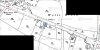
At that time, there were no buildings on the land across the road from The Three Horseshoes Pub, so they definitely weren't there.
In 1932 Ye Olde Wheatsheaf was at 2225 Coventry Road and John Grayland was at 2159.

I agree that the building shapes on the maps, correspond with the pictures and hopefully my following pictures will show that they do.
Thanks again to you all.. merge 4j.jpg sheldonia cafe.JPG
 
Apart from the pubs, I was not familiar with any of the other properties in the discussion. I lived in Lyndon Road from 1940-63 and "thought" I knew the area. I was very wrong.
My note here is to say thanks to all who have opened up this topic and to congratulate you all on the lengths you have gone to to solve the problem. Fantastic work.

OldBrummie Port Macquarie NSW Aus.
 
Lindyloo - Thank you for this additional information. I had followed up my previous post by comparing the Ship photo and the map. I think you have illustrated the situation very clearly.
I lived even closer, as a child, than OldBrummie and probably regularly clambered over the location of the Ship Tea Rooms without any idea of the history beneath my feet:). Very rewarding.
 
Number 2159, as far as i remember there were no properties opposite where the precinct is now, not until they built Halfords etc.

I do wonder if the tea rooms are where the old Music Box record shop used to be, or maybe next door which became an Italian restaurant. Is that still there?

Hi badpenny, regarding your query about the Italian restaurant, it is still there but it has been altered building wise and is now La Caverna Restaurant and Hotel.. as far as I know it is no longer run by the people that were there for many years. I believe those people now have an Italian Restaurant on Arden Oak Road, called La Nonna.
 
La Caverna is 2327 Coventry Road which is way past the Wheatsheaf near the corner of Wells Road. 2159 is as you (Lindyloo) say near to Halfords. Wasn't the Music Shop in the row of shops almost opposite what is now Aldi, between Lyndon Road and Keswick Road???
 
Back
Top