• Welcome to this forum . We are a worldwide group with a common interest in Birmingham and its history. While here, please follow a few simple rules. We ask that you respect other members, thank those who have helped you and please keep your contributions on-topic with the thread.

    We do hope you enjoy your visit. BHF Admin Team
  • HI folks the server that hosts the site completely died including the Hdd's and backups.
    Luckily i create an offsite backup once a week! this has now been restored so we have lost a few days posts.
    im still fixing things at the moment so bear with me and im still working on all images 90% are fine the others im working on now
    we are now using a backup solution

Potter Street, Aston, C1900

sylviasayers

master brummie
Can anyone find Potter Street around 1900. I am pretty sure it is not Potter's Hill, or Potter's Lane. May be around Newtown Row/Summer Lane area.
 
In 1901 it is district 50 sub district St George, Bishop Ryder Parish - RG13 Piece 2845. Other streets in the vicinity, Aston St, Legge St, Fisher St, Digby St.
On the north by Bagot St, on the south by Aston St. On the east by the middle of Legge St and on the west by Lancaster St.

Suzanne
 
Here it is in c 1905

map_potter_st_c_1905.jpg
 
Thank you Suzanne and Mikejee, I can see it is very near where my g. grandfather and family lived in Manchester Street, so not far to walk to work at the Arab Cycle Co.
 
I was looking at this photo c1900 on Shoothill which is captioned 'Site of New Fire Station Potter St, from Lancaster St' and can see the Weights & Measures Office but I cannot seem to locate it on the map in post#3.
PotterSt1900.jpg
 
Last edited:
The dates given for the maps were publication dates. The survey dates were always earlier. The map was probably around 1900. There is a later map c 1915 (probably surveyed c1913), as below, on which I have marked what must be the Weights and measures office from looking at the directories
 

Attachments

  • map c 1915 showing position of the weights and measures dept..jpg
    map c 1915 showing position of the weights and measures dept..jpg
    149.9 KB · Views: 43
great photo phil...funnily enough potter st cropped up on the staniforth st thread yesterday..i have moved this thread to the streets section of the forum

lyn
 
The dates given for the maps were publication dates. The survey dates were always earlier. The map was probably around 1900. There is a later map c 1915 (probably surveyed c1913), as below, on which I have marked what must be the Weights and measures office from looking at the directories
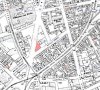
Thanks Mike, I notice your map shows what looks like a little alleyway on the right ... just the first letters of a name showing in the photo.
 
Yes Lyn. Found it difficult to place the fire station by just looking at the Potter Street view. A lot was demolished to make way for it. Viv.
 
Back
Top