• Welcome to this forum . We are a worldwide group with a common interest in Birmingham and its history. While here, please follow a few simple rules. We ask that you respect other members, thank those who have helped you and please keep your contributions on-topic with the thread.

    We do hope you enjoy your visit. BHF Admin Team

Passages, Alleyways Gulletts and Snickets of Old Brum

A wider view from 1902 showing the Midland Institute and cab stand, but no horse this time. The cabman's hut looks quite ornate but not as large as I thought. Viv.

hyhusuza.jpg
 
Silly me, that's not a horse towing a cabman's hut, it's a cab pulled up in front of the cabman's hut. Just magnified Dennis's picture and you can make out the lamps on either side of the cab. Viv.

eqy2umus.jpg
 
Thanks. Great stuff Viv...love the MI pic and Watts' statue..

And now for a ramble round Holloway Head and the narrow still functioning (just) alleys and back Streets round there, like Ernest Street, Bow Street, Windmill Street etc......and speaking of which of course, the History of Chapman's Windmill...as a start...


Chapmans windmill 1865.jpg Chapmans windmill 2.jpg Holloway Head Map 1778.jpg Chapmans windmill map.jpg

On the hill overlooking Holloway Head was Chapman's windmill. It succeeded at least one earlier mill on this site. Gordon Roe in his biography of the Birmingham artist, David Cox, writes, "Joseph Cox's first wife, David's mother, was born Frances Walford, the daughter of a miller and farmer who gave his name to the mill which he had built himself on a high gravelly hill near Holloway Head."

The usual date given for the construction of Chapman's brick-built tower mill is 1745. It was probably built by a member of the Clark family who were millwrights in Deritend until late into the 18th Century. Chapman was still in possession of the mill in 1774, when he made his will, but two years later his executors sold it to John Griffiths. Griffiths put his brother Thomas in as miller while he ran the business as a baker and miller at 114, Hill Street. In April 1778 the mill was struck by lightning. The main beam, one of the sails and a cog wheel were "shivered in pieces, and it was otherwise materially injured, the miller was struck down by the violence of the shock, and remained senseless for some time.”

William Martin took over the mill from the Griffith family, four hundred pounds having been expended on repairs. Originally the mill had a tail-pole, as is seen in an early engraving, but now this was replaced with a fan-tail gear mechanism. During1820's and early 1830's Thomas Lucy of the Stratford-up on-Avon milling family worked Chapman's mill with his sons. After him came the millers Sandbridge Kendrick and Bridges. With Bridges' death the mill fell into decay. The land surrounding it was laid out as a bowling green and pleasure garden. The mill was used as a camera obscura, and from time to time for firework displays under the direction of "Signor Castileo.” In 1873, with the aid of gunpowder, Chapman's windmill was demolished.


Holloway Head 2.jpg

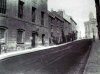
The area in the above picture, where once this row of buildings stood, is little changed even today. The buildings shown were positioned between Windmill Street and Florence Street on Holloway Head, a short distance from the present twin tower blocks and the Radisson Hotel.
The layout of the streets in this area have changed little since the photograph was taken. In 1870 there was little more in the area than can be seen in the photograph. Behind the cottages was open land which was farmed during the 18th and 19th centuries and a windmill, known as Chapman's Mill, after Samuel Chapman who built it in the 1740s, it lent itself to the name of the nearby Windmill Street.

Ernest Street
was cut through the middle of this row of buildings shortly after their demolition, as was Florence Street which is just off the right hand edge of the image. The current petrol station is built on the site of the old Dog and Duck Inn (the building with the canopy on the left). In 1869 this row of buildings consisted of The Dog and Duck (no.89), a Baker (no.86-7), a Butcher (no.84-5), a Greengrocer (no.82), a General Basket Maker (no.80) and the Bowling Green Inn next door at number 79 (nearest the camera).
The area changed from mainly rural and became industrial in nature, many small factories sprung up in the 1870s and 1880s, producing allsorts from lamps and bonnets, metal works, a brass foundry and sewing machine parts.
 
Last edited:
Dennis, The other side of Pinfold St in 1887 showing Christchurch National School. This school opened in 1837 and closed when it moved to Great Charles St around the time that this photo was taken in 1887. The school was reorganised and underwent a name change and finally closed in 1936.
 

Attachments

  • City Christchurch School Pinfold St 1887.JPG
    City Christchurch School Pinfold St 1887.JPG
    163.4 KB · Views: 63
and for luck...any others from that area would be appreciated...I seem to remember Phil being a lurker in the Greyhound in days gone by...as did I on a few occasions....scrumpy heaven...


Bow street.jpg Bowling Green Inn  Holloway Head  1964.jpg
 
Dennis, The other side of Pinfold St in 1887 showing Christchurch National School. This school opened in 1837 and closed when it moved to Great Charles St around the time that this photo was taken in 1887. The school was reorganised and underwent a name change and finally closed in 1936.

Fabulous Phil...another first!

..and I should have thanked the good folk of Digital Ladywood for nicking their superb stuff, and Chris Upton and all who contribute to our Birmingham City Historical wealth so brilliantly...keep em coming boys and girls..!
 
Re. The Dog and Duck first photo in post # 936, artist Paul Braddon's watercolour shows the windmill behind the Dog and Duck. This would have been a retrospective view painted between 1880s - 1930s. Here is the photo compared with the Braddon painting. Viv.

avegunen.jpg
 
Cheers Richie...and another 'just found' atmospheric shot...of Hill Street...before the lovely gothic Post Office building replaced it...


Hill St 1891  Temperance Hotel.jpg
 
One of this Forum's greatest charms (to me, anyway) is that one thing often leads to another...in this case 'shoe shining' to 'ratting'...? Que?? Let me explain....this cracking evocative shot of the Bull Ring Market Hall, taken in 1934, recently appeared in the Birmingham Mail Nostalgia section...and I couldn't help noticing the shoe shining bloke in the foreground...as you do...which reminded me of some of my not too distant trips to Chicago and New York, where shoe shining is still a thriving Street industry, whereas here it has long since died out...I think...


...anyway, then in another of their spreads the next week, an equally brilliant, and very early photo of The Gullett taken in 1870, off Stafford Street, appeared (see the photo and map below for orientation)...


..so I then noted another 'shoe shiner' in the foreround, leaning on the wall...and then, as is our wont Phil, ahem, noted the Pub, The Hope and Anchor. Looked spooky and very seedy I thought, and given the dreadful reputation of the Gullet and it's very poor inhabitants, I checked in McKenna's Central Birningham Pubs Bible to see if it featured, and sure enough, found that it was "situated in the unsavoury part of Town....and the licensee, one Henry Allwood, and no doubt a long time before him, often staged 'dog fights' and 'ratting" matches for his regulars. He goes on : The Rat Pit in the back yard was described as 'an octagonal structure about four feet across, with a woooden floor. The sides consisted of vertical or unclimable iron bars, which rose to the height of about three feet". He then goes on to record that in those days (late 1700s) Stafford Street supported at least eight known public houses or beer houses". Easy to see what our old relatives preferred for recreation?

Anyway, my thoughts then turned to the noble art of Ratting? Never heard of it...but before I digress, again, this is what happened to the old Gullett...


And yes, I know we featured the Gullet many moons ago, but this was too good an opportunity to miss reviving a few memories for newer members...forgive me...
 
The corner Pub in the the Gullet picture #942 has the smallest and narrowest urinal on the side that I have ever seen.
 
Just HAD to look at that small urinal! And by doing so noticed the clothing hanging on the lamp. Must have been a clothes shop there, but it looks quite odd and very high up! Viv.


Sent from my iPad using Tapatalk HD
 
Viv

Given the area and its reputation I suppose the higher the better, at least they couldn't be lifted off the hangers by a passing felon, unless he was about nine feet tall or was carrying a ladder.
 
I remember him as well. He was a permenant fixture, had Sundays off though. Sad looking dog, but beggars' dogs always are. The must be a place somewhere to buy them probable the back page of the Beggars' Bugle - "Fully trained beggar's dog for sale. Sleeps all day, dam and sire still begging in Walsall."
The rumours about that old beggar are still the ones you here about beggars today - " He packs up at six, takes his dog and gets into his Rolls Royce and goes home to Augustus Road.
 
Hi Fabian

Which post are you referring to? I haven't spotted a pic of Ladywell Walk lately.

Paul
 
A million years ago on here, I think Phil featured a little know Bradford Passageway that ran from Corporation Street to Temple Row...now swallowed up by Rackhams...and we didn't have a deent photo of same...but I found this today...not brilliant, but it clearly shows the entrance in Corporation Street...taken on a visit of Her Majesty...

I also include a map and photos by Phil, and a Mail cutout from mikejee for further information...

Bradford Passage.jpg

attachment-1.jpg attachment.jpg BP_6_12_95.jpg
 
That's interesting Dennis. Although the passage is now all under Rackham's/House of Fraser, Bradford Passage must have been alongside the Royal Hotel (at the Temple Row end). So I think the Temple Row entrance to Bradford Passage would have been through the gates (left of Hotel) on this 1830 plate. Wonder if it was called Bradford Passage at the time of the plate because I seem to think it might have led to the Hotel stables. (Hotel is described as a posting house). Also wondering why was it called 'Bradford' passage. Viv.

ImageUploadedByTapatalkHD1387698223.199449.jpg
ImageUploadedByTapatalkHD1387698244.183903.jpg
 
Another engraving, this time 1800, showing the stables to the left of the Royal Hotel. Viv.

ImageUploadedByTapatalkHD1387700389.784136.jpg
 
Here is a better photo of the Old Royal with the junction of Bradford Passage and Temple Row adjacent
 

Attachments

  • City Temple Row Ye Olde Royal.jpg
    City Temple Row Ye Olde Royal.jpg
    87.6 KB · Views: 39
Or maybe his son Samuel who surveyed Brum in 1750, well before Corporation Street however, but his map did show a passage beginning in Temple Alley (Row), roughly where Rackhmam's Goods entrance is today which shared the same alignment and location.
 
Thanks Dennis, Phil and Speedwing. Is it the Royal or the Cobden on Corpn St/ Cherry St? Looks very similar to the Cobden. The original Royal building must have had major redevelopment. Viv.

Here's the Cobden looking north towards the original corner Rackhams (out of view though). Bradford Passage is level to where the back of the bus is. The retail premises of Walter Austin in both pictures identifies thing more exactly

image.php
 
Back
Top