-
Welcome to this forum . We are a worldwide group with a common interest in Birmingham and its history. While here, please follow a few simple rules. We ask that you respect other members, thank those who have helped you and please keep your contributions on-topic with the thread.
We do hope you enjoy your visit. BHF Admin Team
You are using an out of date browser. It may not display this or other websites correctly.
You should upgrade or use an alternative browser.
You should upgrade or use an alternative browser.
Park Location
- Thread starter pudding
- Start date

Phil
Gone, but not forgotten.
Pudding
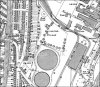
It certainly looks like no park that I would recognise in Nechells, my first thought would be Collowfields Recreation Grounds now called Garrison Lane Park because of the line where the ground level steps down which is only in evidence today by a slight hill. If pushed for another guess I would have to say Adderley Park but only because it matches the size of that in the photo.
It certainly looks like no park that I would recognise in Nechells, my first thought would be Collowfields Recreation Grounds now called Garrison Lane Park because of the line where the ground level steps down which is only in evidence today by a slight hill. If pushed for another guess I would have to say Adderley Park but only because it matches the size of that in the photo.
Phil
Gone, but not forgotten.
Pudding
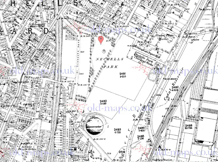
I have to revise my first opinion, on studying the old maps I see that there was indeed a Nechells Recreation Ground until the turn of the last century it was much larger until they extended the gas works. It was situated at the rear of Saltley Gasworks and ran to St Clements Road and Cattells Grove as can be seen on this map. You can certainly learn something new (or old) every day on this site.
p.s. Pudding you will know I've nicked a copy won't you.
Attachments
pudding
master brummie
Thank you Phil, for your reply and info relating to the photo.
when I first saw the picture I thought it was Eliot st park (known locally as the old laddies park) but when I notice the chairs and the large roller for a green then no way, the building is very similar to the park keepers house that is still there today
I am very surprise that Nechells once had a band stand.
p.s Of course I know Phil
In the 1880s the Park was called Nechells Park , and the Nechells Chemical Works was called the Nechells Park Chemical Works. After the extension to the gas works and the chemical Works was built on that side of the railway, reducing the size of the park to about a quarter of its previous size, it is listed on maps as a recreation ground
Phil
For some reason, as you can see from the c1890 map, there was one gasometer at the corner of the park then, separated from the rest of the gas works. Not certain if at any time there was more of the gasworks under what became the park, though I doubt it -people didn't usually build things just for a 10 years life then.
For some reason, as you can see from the c1890 map, there was one gasometer at the corner of the park then, separated from the rest of the gas works. Not certain if at any time there was more of the gasworks under what became the park, though I doubt it -people didn't usually build things just for a 10 years life then.
