• Welcome to this forum . We are a worldwide group with a common interest in Birmingham and its history. While here, please follow a few simple rules. We ask that you respect other members, thank those who have helped you and please keep your contributions on-topic with the thread.

    We do hope you enjoy your visit. BHF Admin Team

Map Request

bandito22

Brummie babby
Hi everyone, love looking at these amazing old images of Birmingham where I grew up in the 70's.

Until the age of 5 I lived in Small Heath, very very near to the Blues ground and I have a request for a map and photo's of that area that shows where my house once stood.
Sadly, my Father was killed in that house so I would really like to pinpoint where it was.

Unfortunately, due to my age at the time, I have very few memories or details to go buy but here they are:

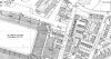
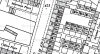
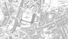
1. We lived in a terrace of back to back houses, ours was 5 back of 67 with an outside loo.
(I would hope this unique combination of address would help pinpoint our house).

2. For many years I was sure that the open end of the terrace faced the Blues ground but this may not be entirely accurate.
Either way, the ground was very very close. The fans cars would line the streets on match day.

3. I went to Sunday school at a church that was at the end of one of streets within walking distance for a small child.

4. The surrounding houses were being demolished by 1975 and ours was demolished that year too.

5. I always thought we lived somewhere on St.Andrews road but again, this may be erroneous.


I realise this is very scant information but any help would be greatly appreciated.

Alan.
 
Alan
As far as I can see it must have been in Tilton road, as that is the only road with terraces behind no 67 on that side of the ground. The railway bordered the west side. Below is a map showing that general area. also a larger scale map to show numbering. I think the mapmakers got numbering wrong , as it shows 1,2,8910,11 back of 67, then 3,4,5,6,7 back 69 and 3,5,6,7,8 back 61 and 4 back 61. I presume no 5 back 67 is one of the two in pink marked as 5 back 61 or 5 back 69
 

Attachments

  • map c 1966 showing are to east of City Grouns.jpg
    map c 1966 showing are to east of City Grouns.jpg
    397.9 KB · Views: 44
  • map c1966 showing back terraces of tilton road close up.jpg
    map c1966 showing back terraces of tilton road close up.jpg
    135.7 KB · Views: 39
hi alan and welome to the forum what year did you leave the house in small heath ?..if you felt ok about giving us your parents full names we could check the online electoral rolls on ancestry to determine the exact address that they lived at..ancestry only go up to 1955 with their e rolls but one or two of our members may have access to the 1960 and 1965 e rolls..

all the best

lyn
 
Last edited:
The 1955 online electoral roll shows that the houses back of 67 are 1, 6, 7, 8, 9, 10 and 11. I have no idea why. It is the same with some others as well and then others are as you said.

Janice
 
Hi Janice

The houses that you mention were known as either back of 67 or 69 as these were the houses
fronting the street either side of the tunnel. My house certainly was called 8/69 on the rent book.

If you look at the backs of the front houses, there are the missing numbers.

Kind regards

Dave
 
tilton rd showing the royal george on the left and tilton rd school at the end and the houses on mike,s maps on the right.Tilton Road__.jpg
 
Thanks - I was just pointing out that on the electoral roll 5/67 is not listed at all. Unless the house was 5/ one of the other numbers as Mike suggests.

Hi Janice

The houses that you mention were known as either back of 67 or 69 as these were the houses
fronting the street either side of the tunnel. My house certainly was called 8/69 on the rent book.

If you look at the backs of the front houses, there are the missing numbers.

Kind regards

Dave
 
Firstly, thanks to everyone for all the information and images.
MikeJee, those maps are just what I have been trying to find. Thanks.

Now that I see the numbers I wonder if we were actually 5/69??

The first thing that doesn't fit with my recollection is that if you came out of our front door and looked towards the main road there was (what I perceived as) the blues ground but could have been some other structure just very close to the blues ground. Either way, there were no houses/alleyway or anything else between us and the main road.

I suppose the main front houses (63-71) could have already been demolished by 1970-73?

MikeJee, do you have the wider shot of the area so I could try to get a mental image of what else was around the area back then?
Are there any other 5/67's (or 69's) around that area??

Some other minor detail I have recalled since posting this.....
- there was a scrap yard very close to the house which I would love to locate on the map.
- from my bedroom window I am sure I could see the clock on top of the rotunda, would that fit in with this location??
- my cousin seems to recall 'Mount Pleasant' as a possible name of the terrace (I just recall it wasn't very pleasant!) Is there any such place around there??

Thanks again for all your help.
 
Hi Bandito22,

Yes, there were 2 scrap yards close by, one was Thomas Allen Metals in Garrison Lane, and Jubilee Spares in Venetia Road.
I'm wondering though when Jubilee Spares was started, - if it was named after the Queen's Jubilee it would have been
later of course.

You would have had difficulty in seeing the Blues Ground from number 5 as there was no gap between 67 and 69, just the
tunnel.

There didn't appear to be any distinction between /67 and /69, and I used to get letters addressed to either, as there
was only one series of numbers in the yard

Incidentally, I was told that one of the houses at the back of the street terrace was so infested with cockroaches
that if you went downstairs at night without putting the light on, you could leave your footprints in them!

Kind regards

Dave
 
As I said in my earlier post, I looked hard and could see no nUmber 67s with terraces behind in the area around the ground. Below is a wider map of the area, (c 1951),though, of necessity, not as detailed.
 

Attachments

  • map c 1951 area around St Andrews.jpg
    map c 1951 area around St Andrews.jpg
    483.4 KB · Views: 27
Just reread #1 and the thought occurred to me that if, sadly, Alan's father died at that address then it should be on his death certificate.

Janice
 
Thanks again for the updated info. I still cannot reconcile the fact that the front of the terrace definitely opened onto the main road. So would love to know when 63-71 were demolished.
How can I get hold of these detailed maps?

My dad's name was Philip Insley and he died in 1975 from injuries sustained at that house. Not sure if it was classed as murder or manslaughter. Any info on that would also be very welcomed.
 
A visit to the Central Library and a check in the electoral rolls will show when 63 to 71 were no longer listed. They could also show if the address in Tilton Road is correct for your parents as they should be listed.


Janice
 
Hi

I left 8/69 Tilton Road in November 1969, and not because of demolition.

My recollection is that they came down in the early 70's

Kind regards

Dave
 
Hi, thanks for the info. I was still there when all the other houses were being demolished around us in 1974/75.

Do you remember whether the main 63-71 houses were still standing when you left?


I know the road we lived on opened directly onto the main street, so still not convinced this is the correct place.
I need to get to the library and find the death details.


Hi

I left 8/69 Tilton Road in November 1969, and not because of demolition.

My recollection is that they came down in the early 70's

Kind regards

Dave
 
Hi,

None of the houses in the Garrison Lane to Cattell Road end of Tilton Road were demolished when I left.
Of course, the space at the corner of the road past 71 (opposite the Royal George), was due to bomb
damage and not demolition. The space was crammed with fans' cars on matchdays.

Kind regards

Dave


Thanks again,

Based on that information I think we must have been a bit further from the ground than I Imagined.
 
You mentioned Mount Pleasant, on a earlier post, which was on the main Coventry Rd . Just a thought...
 
Back
Top