• Welcome to this forum . We are a worldwide group with a common interest in Birmingham and its history. While here, please follow a few simple rules. We ask that you respect other members, thank those who have helped you and please keep your contributions on-topic with the thread.

    We do hope you enjoy your visit. BHF Admin Team
  • HI folks the server that hosts the site completely died including the Hdd's and backups.
    Luckily i create an offsite backup once a week! this has now been restored so we have lost a few days posts.
    im still fixing things at the moment so bear with me and im still working on all images 90% are fine the others im working on now
    we are now using a backup solution

Rivers: River Tame

I think all the rivers have had a bit of a clean up. We live close to the river Cole at Bacons End and a couple of years ago there was a sighting of an otter in the river.
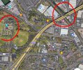
The Cole and the Blythe from Coleshill join the Tame behind the houses in Station road ,near Hoggrills End.
 
As an inland sailor who occasionally tends to capsize, I must add that the efforts that have been made, probably since the 1960s, to clean up inland waters of all kinds are greatly appreciated. One of the things that helps is to share a water with a fishing club, the aim of most of the users is for clean water and a decent environment in which to enjoy your respective sports.


38360811-4EAE-4F13-AD1C-771006D2CD5F.jpeg

Me at the helm! The boat is an Albacore. At the time this was taken, the combined age of the helm and crew was approaching 150.
 
Last edited:
I saw an otter last year on the bank of the rive Cole between Chelmsley Wood and the M6 bridge whilst walking my dog, he was on the other bank sitting looking at me, wish I'd had my camera. I go that way every day with my dog, so now take my camera but have not seen him since. The Cole is a surprisingly clean river and joins up with the Blythe by Coleshill. Eric
 
Floods I remember
I remember floods on the Walsall Rd. The Midland Red Buses could only get through to Birmingham by diverting down Church Lane and along the Aldridge Rd over the new bridge. Flood prevention work on the River Tame has solved the flooding problem.

Looking south towards the city
Walsall_Rd_Flood.jpg

Looking north
1947_Walsall_Rd_Floods.jpg
 
I’m not able to find a specific answer to Richard’s question in post #39 but in April of that year, two schemes were proposed for widenening and deepening of the Tame in the area. The ZigZag bridge at Perry Barr was to be underpinned too and a bridge across the Old Walsall Road was to be raised. Again, don’t know if this was implemented. Viv

D154DA67-92FE-4CAB-8C6F-AB5E7D22B923.jpeg
Source: British Newspaper Archive
 
Keith Berry photographed work on the river and took other photos in the area
RtamePH.jpg
My thoughts about the work was that the water would flow faster to Witton
From KB4 in following archive
 
Floods on the Walsall Road from the River Tame

View attachment 170811
View attachment 170812
Yes, Tuckers - my Dad worked there!
My junior school friend lived in one of those houses and I remember her telling me the ground floor flooded - we lived off the Walsall Road further up and the water didn't get that far fortunately!
I know they did find a solution eventually which involved the part of the Tame in Perry Hall Park.
 
Jan 1949 Several hundred residents of Witton and Perry Barr attended protest meeting at Deykin Avenue school about the recent flooding of the Tame.

November 1949 the Ministry of Agriculture asked the Trent Catchment Board to investigate periodic flooding of the Tame at Perry Barr.

1950…Two plans to tackle flooding. The major one involves spending £90,000 on widening a deepening from Salford Bridge to near Walsall Road.

In August 1956 there is a poor picture of workmen at Walsall Road bridge, lowering the bed of the Tame.

Later in Dec 1978 there is a £6.5 m plan to reduce risk of flooding of Tame in Birmingham and Black Country, involving storage lakes which can be used for recreation. To be completed by 1985.

The scheme is described as a world leader. (That term seems to sound a bit familiar!). The proposed lake sites are at Sandwell, Wednesbury, Walsall and at Sandwell valley. (Also proposed to use land at
Perry Hall fields as wasteland areas.)
 
Last edited:
Even in 1954 contingencies were in place for flooding, including the evacuation of greyhound dogs. Viv.

18A4E6D9-0969-4E1D-8380-EF71BB42F922.jpeg

The riverbed by the bridge on Walsall Road was lowered in August 1956 (Birmingham Post, 28/8/1956)


And there’s still flooding in the area in 1966.
EDCAA5E4-AC75-4EBD-AF04-57AABE580FCC.jpeg
Source: British Newspaper Archive
 
Last edited:
This painting by John Joseph Hughes, a local Handsworth resident and councillor, appeared on a modern day USA auction house site. The painting was named “The Thame at Witton” I think this must be referring to the River Tame, with Aston Hall on the higher ground in the distance. Given the references in the painting it might even be possible to locate this point of the river today. Viv.

784EB9F4-453C-4743-A15B-F4B8523B11ED.jpeg
 
This painting by John Joseph Hughes, a local Handsworth resident and councillor, appeared on a modern day USA auction house site. The painting was named “The Thame at Witton” I think this must be referring to the River Tame, with Aston Hall on the higher ground in the distance. Given the references in the painting it might even be possible to locate this point of the river today. Viv.

View attachment 172362
What a beautiful scene compared to what I remember.
 
From the Trust information above it shows what I think is discharge into Hawthorn Brook…

Witton - Gec Grounds (Cso) (Severn Trent Water)….in 2021, this sewer storm overflow spilled 33 times for a total of 37 hours, discharging into the Trib River Tame.

Witton - Gec Grounds (Cso) (Severn Trent Water)


11C6988B-1960-4646-AC4D-23AF1D3EF518.jpeg
 
An observation here, please comment if my assumptions are off the mark.

The discharge into Hawthorn Brook shown above is reasonably close to the River Tame, and below Brookvale Park and Witton Lakes. However there is evidence of a further discharge into a tributary of Hawthorn Brook that would feed down into Witton Lakes…

Green Lanes Cso (Severn Trent Water)….In 2021, this sewer storm overflow spilled 3 times for a total of 2 hours, discharging into the Tributary Of Hawthorn Brook.

This is in the open section near Marsh Lane as shown below.


CB550ECF-B997-4CAC-8A48-142B2A4C0AD1.jpeg
 
Back
Top