• Welcome to this forum . We are a worldwide group with a common interest in Birmingham and its history. While here, please follow a few simple rules. We ask that you respect other members, thank those who have helped you and please keep your contributions on-topic with the thread.

    We do hope you enjoy your visit. BHF Admin Team
  • HI folks the server that hosts the site completely died including the Hdd's and backups.
    Luckily i create an offsite backup once a week! this has now been restored so we have lost a few days posts.
    im still fixing things at the moment so bear with me and im still working on all images 90% are fine the others im working on now
    we are now using a backup solution

Hay mills area

Eatonways coaches next to the rec, I mentioned this a few years ago on B'ham history and got shot down in flames. when I was a young 4 5 6 year old we often went on day trips with them and they differently had a base there glad to here someone else remembers this.
Yes , Podgery you are correct , the layout was Bedders fish and chip shop, then the shop that Bowen’s later took over as a booking office for Bowen’s coaches (as the took Eatonways over when the went bust) , the the car showroom petrol station, with Eatonways offices up stairs , you then had the half moon / crescent area that led to the Heybarnes rec .
The half moon area was used to park the coaches on but it was originally a turn around area for buses (58/60)
Am i right the bus that turned at the half moon area was the 58B. I seem to remember having to get off the bus there and walk up to Redhill road from there when we caught it from town.
 
We use to play football and cricket in Redhill School during the summer holidays , had climb over the fence and keep an eye out for the caretaker.
 
I remember a government surplus place somewhere on the main road in Hay Mills. I used to go there a lot in early days, there was a lot of stuff that was magical to me at that age but there has been nothing top up the memory and it has faded. I remember it as being on the left if Birmingham was behind you, but I am completely lost looking at recent maps as to where it was.
Another place was where me and mates used to spend great evenings jamming with our guitars and drums, second half of the 60s. I am sure it was a police house, and detached so we didn’t disturb anyone. The drummer lived there so we didn’t have to shift his kit about. I feel that it was nearer the Swan, so maybe Yardley rather than Hay Mills. I remember the inside perfectly, (and playing ‘wipeout’ so the drummer had to work harder), but just can’t place it on the map.
My last memory is a friends place on the Cov Road, almost opposite the Rootes place, so again my not be quite Hay Mills. It was on a corner with a road that had a short but strange (to me) name. I used to park my Lambretta at the end of that road, then turn left onto the Cov Road and up the steps. The front door was up several steps, and I have a clear view of looking out of the front room, down onto the main road, but looking on maps it seems to have changed so much I can’t orient myself. Google street view is not helping me at all.
I don’t want to lose these memories totally. Anybody out there can fill in a bit please?
Andrew.
 
We use to play football and cricket in Redhill School during the summer holidays , had climb over the fence and keep an eye out for the caretaker.
I went to Redhill school from 1950 -1955 played football and cricket for the school and yes played in the playground when we could.
 
I remember a government surplus place somewhere on the main road in Hay Mills. I used to go there a lot in early days, there was a lot of stuff that was magical to me at that age but there has been nothing top up the memory and it has faded. I remember it as being on the left if Birmingham was behind you, but I am completely lost looking at recent maps as to where it was.
Another place was where me and mates used to spend great evenings jamming with our guitars and drums, second half of the 60s. I am sure it was a police house, and detached so we didn’t disturb anyone. The drummer lived there so we didn’t have to shift his kit about. I feel that it was nearer the Swan, so maybe Yardley rather than Hay Mills. I remember the inside perfectly, (and playing ‘wipeout’ so the drummer had to work harder), but just can’t place it on the map.
My last memory is a friends place on the Cov Road, almost opposite the Rootes place, so again my not be quite Hay Mills. It was on a corner with a road that had a short but strange (to me) name. I used to park my Lambretta at the end of that road, then turn left onto the Cov Road and up the steps. The front door was up several steps, and I have a clear view of looking out of the front room, down onto the main road, but looking on maps it seems to have changed so much I can’t orient myself. Google street view is not helping me at all.
I don’t want to lose these memories totally. Anybody out there can fill in a bit please?
Andrew.
Was the Government surplus place called Wooten's I seem to remember this place being on the corner of Hay road and Cov road.
 
I remember a government surplus place somewhere on the main road in Hay Mills. I used to go there a lot in early days, there was a lot of stuff that was magical to me at that age but there has been nothing top up the memory and it has faded. I remember it as being on the left if Birmingham was behind you, but I am completely lost looking at recent maps as to where it was.
Another place was where me and mates used to spend great evenings jamming with our guitars and drums, second half of the 60s. I am sure it was a police house, and detached so we didn’t disturb anyone. The drummer lived there so we didn’t have to shift his kit about. I feel that it was nearer the Swan, so maybe Yardley rather than Hay Mills. I remember the inside perfectly, (and playing ‘wipeout’ so the drummer had to work harder), but just can’t place it on the map.
My last memory is a friends place on the Cov Road, almost opposite the Rootes place, so again my not be quite Hay Mills. It was on a corner with a road that had a short but strange (to me) name. I used to park my Lambretta at the end of that road, then turn left onto the Cov Road and up the steps. The front door was up several steps, and I have a clear view of looking out of the front room, down onto the main road, but looking on maps it seems to have changed so much I can’t orient myself. Google street view is not helping me at all.
I don’t want to lose these memories totally. Anybody out there can fill in a bit please?
Andrew.
The old army navy stores was on the corner of Shipway Road and Coventry Road they had stalls set out on the footpath , you could buy old gas masks, army coats, ammo belts, they even had the mirror type periscope sights for tanks.
The house you visited was a police house and next to it was our GP Dr Lloyd, those houses were a pair of semi’s and the rest of the road was terraced large Victorian type house’s .
Thanks. I do remember now the shop extending onto the pavement. The mention of periscope sights has triggered another memory from that place that had been buried. I never had one, but I can remember the feel of them, and looking through and seeing the slightly different view.
At the police house, we were all school mates. I remember his name quite clearly, and he was going on to join the police after school, via college I think, whereas I was going into electronic engineering. Do you have a nearby street name that will let me home in on it.
Andrew.
 
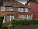
The house were your mates lived were built on land were house were bombed during WW2 air raids on the BSA ( I was told by locals) , they were numbered 860 a and 858 b
screenshot attached shows them now, I have somewhere (and it is nagging me now) pictures of Rootes , Holy Family church and houses on Coventry Road, .
I will get in the loft and see if I can find them and I will post them on this site,
 

Attachments

  • CF410E38-100D-46CB-9AFB-CCF035889923.jpeg
    CF410E38-100D-46CB-9AFB-CCF035889923.jpeg
    543.4 KB · Views: 15
I believe the man standing by the Powell's Bakery cart is my Great Grandfather, Oliver Morris. My Mother has this photograph of him passed on from her Mother. He worked for J T Powell, the bakery was based at 25 Coventry Road from around 1896, the road was then altered and the numbers changed, they also had a branch on Shipway Road and sold on the business in the 60's.
 
Back
Top