Mike. That map in post #2 is interesting in that, for a time, we lived in Brunswick Road. From memory, number 103. On the posted map, going NW from
Mike. That map in post #2 is interesting in that, for a time, we lived in Brunswick Road. From memory, number 103. On the posted map, going NW from White Street, and count 12+ residencies, there is an alleyway, which actually branched to the rear of adjoining properties. On the right of the alleyway [as per viewing the map] was where I/we resided.
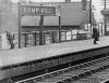
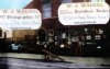
Your map shows, on the other side of the road, 'avenues' of houses. I can't remember them. I can certainly remember 'bomb sites' in that vicinity where we used to play. NW of those 'avenues', and on the same side, were a group of about five shops. One I can remember as being a Newsagent but as for the others.......
Another feature in the road was Denhams Taxis. They were on the same side as us but possibly the other side of White Street. Their main Business was Wedding Cars and had significant parking within/through the premises.
If you could post an updated, downloadable map, I would be grateful.
Mike. That map in post #2 is interesting in that, for a time, we lived in Brunswick Road. From memory, number 103. On the posted map, going NW from White Street, and count 12+ residencies, there is an alleyway, which actually branched to the rear of adjoining properties. On the right of the alleyway [as per viewing the map] was where I/we resided.
Your map shows, on the other side of the road, 'avenues' of houses. I can't remember them. I can certainly remember 'bomb sites' in that vicinity where we used to play. NW of those 'avenues', and on the same side, were a group of about five shops. One I can remember as being a Newsagent but as for the others.......
Another feature in the road was Denhams Taxis. They were on the same side as us but possibly the other side of White Street. Their main Business was Wedding Cars and had significant parking within/through the premises.
If you could post an updated, downloadable map, I would be grateful.
Street, and count 12+ residencies, there is an alleyway, which actually branched to the rear of adjoining properties. On the right of the alleyway [as per viewing the map] was where I/we resided.
Your map shows, on the other side of the road, 'avenues' of houses. I can't remember them. I can certainly remember 'bomb sites' in that vicinity where we used to play. NW of those 'avenues', and on the same side, were a group of about five shops. One I can remember as being a Newsagent but as for the others.......
Another feature in the road was Denhams Taxis. They were on the same side as us but possibly the other side of White Street. Their main Business was Wedding Cars and had significant parking within/through the premises.
If you could post an updated, downloadable map, I would be grateful.