• Welcome to this forum . We are a worldwide group with a common interest in Birmingham and its history. While here, please follow a few simple rules. We ask that you respect other members, thank those who have helped you and please keep your contributions on-topic with the thread.

    We do hope you enjoy your visit. BHF Admin Team
  • HI folks the server that hosts the site completely died including the Hdd's and backups.
    Luckily i create an offsite backup once a week! this has now been restored so we have lost a few days posts.
    im still fixing things at the moment so bear with me and im still working on all images 90% are fine the others im working on now
    we are now using a backup solution

1865 Birmingham panorama

Still finding my way around this site and tend to 'happen' on things by accident. I found the discussion on the viaduct really interesting. Can anyone tell me where to find the thread with the picture of the Cattle Market please? As mentioned in the December post from Speedwing.

It was in the Courtyards and yards of Brum thread in post number 292
 
Well, everyone - thank you so much for your contributions. I seem to be always asking questions so must now try to put something back. Not sure what at this moment.

We tend to spend a lot of time looking round this city for 'bits of old'. The cattle market has come up a few times in connection with family history and the railways. I certainly didn't expect to see such a good photograph.

I look forward to following up all the links. Again, thanks.
 
If you go to Google Earth today. you can still see the openings/entrances post #28 and #30 and there are street view pictures to be seen by using the little man. The buildings on post #28 have gone but you can see a few feet high of the wall above the sidewalk that runs along most of the street. The opening is wider now where the two guys are talking, alowing two lanes but where the wall has been removed to facilitate this; there is a tarmac filling showing where the removed part of the old wall used to be.
The entrance to the northern end of the cattle market is still there to be seen and the road in is still pretty much the same except that the Viaduct has dissappeared. The photo referred to in this post #30 is the only one that I have ever seen of this part of the Viaduct...only sketches before like the subject sketch. The Viaduct arch on the right must be the last one I think and the Viaduct came to an abrupt stop there. Somewhere about the next arch in the Rae ran through and must have been culverted just out of view in the picture so it goes underground somewhere there to re-appear again further down stream. Actually the sketch shows many places and locations that can be reffered to on other sketches like the Westley Aspect.
Both of these recent photo's are great additions.
 
I have uploaded this copy of Thomas Sulman's Panorama which is a slight improvement on the previous version.

P1010719-001.JPG

It also includes the vignettes of the City

Sorry, can't upload the full scan as it exceeds the hosting site limits being over 100mb.
 

Attachments

  • P1010719-001.jpg
    P1010719-001.jpg
    505.4 KB · Views: 58
  • thumb_P1010719-001.JPG
    thumb_P1010719-001.JPG
    1.9 KB · Views: 107
Firstly my post 25 in this thread has been amended slightly.

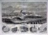
Reference was made to the bridge shown in the foreground of Sulman's Panorama which was demolished at some point in the early 20's or even before perhaps as early as 1883.

Montague Street 14.jpgMontague Street 15.jpg

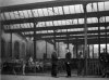
These are from Roger De Boer's "Birmingham's Electric Dustcarts" which though out of print is available at eight of the City's local libraries plus the Library of Birmingham Reference section. (628.44209424)
The original glass negatives were discovered in a drawer at the old offices of the Salvage Department in Montague Street though where they are now is a bit of a mystery.

In the background is the remnants of the bridge featured in Sulman's panorama viewed from the Corporation yard looking east with the Montague Street Pig and Cattle Market beyond the facing brick wall.

Clearly the bridge was supported on six iron columns supporting two cast iron beams in an almost identical manner to the surviving structure in Cerro's yard off Liverpool Street and easily visible through their gates.

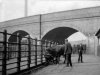
Spanning these beams would have been a timber frame structure supporting the trackbed which would have been similar in detail to those used on the line up from Oxford and to those erected along the line between Plymouth and Penzance.

The pictures show the sawn off remains of the timber trusses poking out the brickwork and the supporting sandstone pads which still exist today in remaining brick abutments at Liverpool Street, Great Barr Street and Montague Street.
Pencil sketches on one of Brunel's contract drawings for the viaduct provides confirmation of what must have been a change of plan when it became obvious the connection with Curzon Street station was frustrated. Hopefully I will have a drawing of the structure based on measurements of the brick courses in each photo and Brunel's Design office drawings for inclusion in the near future.

As luck would have it there are views of the east side of the viaduct before it was finally demolished and these can be found in the Library of Birmingham's Warwickshire Photographic Survey which includes nine images taken by George Whitehouse of the Pig and Cattle Market.

This link should take you to the online collection though the quality of the scans is a bit dubious or from the their catalogue reference MS 2724/2/B/2609 through to 2617

https://calmview.birmingham.gov.uk/...rc=CalmView.Catalog&id=MS+2724/2/B/2609&pos=1

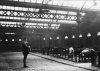
Imagine having walked through the entrance in Montague Street seen in earlier posts and looking north. The viaduct is visible along the left with the offices of the Salvage Department appearing beneath the arches. Imagine also the smell!

The second looks through the arches toward Banbury Street and the City in the open section of the Cattle Market near the stalls where stock would be received from Midland railway Cattle Dock nearby.

The third taken inside the Pig market looks north east along the inside curved wall fronting Montague Street.

Finally K4 Architects of Fazeley Street have produced a speculative vision of the area based on recycling the remaining section of the viaduct between Upper Trinity Street and Liverpool Street.

https://www.k4architects.com/duddeston-viaduct/4578897594
 

Attachments

  • Montague St 5a.jpg
    Montague St 5a.jpg
    180.1 KB · Views: 40
  • Montague St 7a.jpg
    Montague St 7a.jpg
    173 KB · Views: 40
  • Montague St 8a.jpg
    Montague St 8a.jpg
    181.2 KB · Views: 41


A to E are along New Street
A) Is the Theatre, by the time of the painting, the Theatre Royal.
B) Next to the theatre was Portugal House, a grand Georgian town house, at the time of the painting divided into two properties with a distillery attached.
C) Just over the street is the original Georgian cottage Post Office, which had at its rear...
D) The Post Office yard where the Royal Mail coaches would arrive from 1812.
E) Is the Panorama, where 360 degree actual size paintings were shown.
F & G are in what is now Victoria Square
F) Is Christ Church, the interior of which can be viewed by following the link.
G) Is placed just to the left of the flag that topped Allin's shop, nicknamed The Flag as it always flew the Union Jack. The Town Hall was later built near this spot. In the distance, behind the 'G', is the Canal Offices on Paradise Street.
H) Is the walled garden attached to Bennett's Hill House, the house just out of view on the right. All the green land in that area was the original Bennett's Hill, and had been protected from building work by a clause in the 120 year lease for the house and land. The lease had expired in 1818 and not long after Lines's painting the whole are was built up with two new roads, houses, shops and other businesses.
https://mappingbirmingham.blogspot.co.uk/search/label/Spectacle and Entertainment
 
Back
Top