 The Royal hotel Temple street c1800 have you tried this site Viv https://mappingbirmingham.blogspot.co.uk/2012/10/the-hotel-temple-row.html
-
Welcome to this forum . We are a worldwide group with a common interest in Birmingham and its history. While here, please follow a few simple rules. We ask that you respect other members, thank those who have helped you and please keep your contributions on-topic with the thread.
We do hope you enjoy your visit. BHF Admin Team
You are using an out of date browser. It may not display this or other websites correctly.
You should upgrade or use an alternative browser.
You should upgrade or use an alternative browser.
Cherry Street
- Thread starter Astoness
- Start date
Fantastic Mike, what an interesting map. So Lower Cherry Street partly lies under Corporation Street outside Rackhams/House of Fraser frontage. Well I'd never have sorted that one out. Thanks.
Alberta, do you remember much about the interiors of the solicitors you delivered to? Can imagine the purpose-built victorian offices would have been interesting inside with lots of dark wood and glass partitioning. Viv
Alberta, do you remember much about the interiors of the solicitors you delivered to? Can imagine the purpose-built victorian offices would have been interesting inside with lots of dark wood and glass partitioning. Viv

 a1750 bRADFORD MAP COUTESY OF THE gEORIAN sTREETS SITE NOT THE BEST SO HERE'S A LINK https://mappingbirmingham.blogspot.co.uk/search?q=CHERRY+STREET
The naming of streets in that small area seemed to change a lot. Invariably Cherry St. ran down to High St. and then only to Crooked Lane to become Union St, on the rest of the way to High St. Crooked Lane itself was also partly called Little Cherry or Upper Cherry for the Ell upper part that dissapeared when Corporation St. was put through. We have photo's on here that seem to label new buildings as Cherry located and these buildings were possibly replacing the buildings in the wonderfull photo of Little Cherry, (what a smasher and first sighting on here). Anyway, at that time the new Corporation St. had not been named so perhaps the owners of the new buildings had no intention of having an address on 'Crooked Lane' (not exactly a prospect for the location of business) and so put Cherry on the building. It's all just conjecture to flavour debate. The builings on the Little Cherry St photo seem to be verging on being derelict at the time so it must have been close to the building of Corporation St. We also have photo's of the old Union St. at the junction with Cherry St. (1870) but it might have been with Crooked Lane also at the time of demolition and not Little Cherry as shown on Mikes map. Little Cherry or Crooked Lane led off to the left at the corner where the curb post is.
Attachments

Excellent find Bernie. You do get a sense of a once bustling commercial area from the Little Cherry Street photo, especially when combined with Rupert's photo of the Union Street/Crooked Lane junction. The Crown (Inn/Tavern?) looks to be still in business in the photo as does the Provisions Broker. But the building between the two does seem abandoned. The Crown block of buildings looks, to me, much older than the larger adjoining block. Rupert your suggestion that businesses wouldn't want a 'Crooked Lane' address sounds completely feasible. And you're right about the name changing (very confusing), and at a time when realignment of some of these connected streets adds to the confusion. This extract from a B'ham Archaeology data service report talks about the busy development period between 1731 and 1751. Viv.

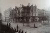
Tracked down some photos showing a glimpse of Cherry Street. The focus is the Cobden Hotel on the Corporation Street/Cherry Street corner in the first two. The first is of the Cobden Coffee Palace (!) in 1883, the second is the Cobden just prior to demolition in the late 1950s (to make way for Rackhams store) and the third, well, the band played on!


Interesting that the lower part of the Cobden in the 1883 photo, which I assume is the coffee palace, resembles a Victorian pub. The 'palace' was intended to tempt people off the demon drink. Viv.
Interesting that the lower part of the Cobden in the 1883 photo, which I assume is the coffee palace, resembles a Victorian pub. The 'palace' was intended to tempt people off the demon drink. Viv.
If you look at the 1883 picture of the Cobden...bottom right of it. The railing and corner bollard are the same ones shown on the photo in post 18. If you look to the right of the Cobden you will see that the street is still un-developed at that point. Maybe as far as the Arcade builing shown in the following photo included which must be a tad earlier because the Cobden is not on it.
The second photo included is one from across Corporation St in our time but of the end of the same Arcade building and look at the Cherry Street sign!! Pity it does not go further to the left it might have included "Little" or 'Upper" or something else to explain.
If the buildings on Little Cherry St. post #16 are in fact rightly named maybe they would have been just in front of the Cobden possibly...the corner railings having stayed in place and Corporation Street being much wider.
The second photo is before the Cobden and maybe you can just see the faint outline of the roof lines of the old Little Cherry Street buildings post #16...just being cleared. The Little Cherry Street photo seems as though it may have a south east facing by the amount of light. I wonder if there is a positive location for those buildings on Little Cherry.
If you look at the buildings being demolished at the left edge of the second photo...they seem to be further out in the new Corporation Street and at a slightly different angle; which would tie in with the maps. Is this a last semblance...sighting of Little/Upper Cherry and is the street on the left end of the photo in post #16 actually Cherry Street propper...the corner where the Cobden would be.
Attachments
oldMohawk
gone but not forgotten
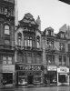
I had two favourite shops in Cherry Street - Grenvilles Sports Shop near the Corporation St end and The Model Aerodrome on the corner with Temple Row. Looking at this forum pic dated 1972, a sign advertises something for Monday 2nd October... wonder what it was ?

Last edited:
oldMohawk
gone but not forgotten
There's one of my favourite shops...
Cherry Street 1960 (?) From John Ball's incomparable photo portfolio

Can't figure that one Viv. Super shot and showing no sign of any road revision. The slope is the wrong way for it to be the Cannon St. entrance. Shaddows possibly indicate that south is to the left so maybe that is somewhere on Upper Cherry again. Sometimes photo's are improperly labelled though and sometimes reversed. Might be in the lower elbow of Little Cherry which would have had a bit of a slope to it in that direction. So maybe that corner lower right would have been the junction of Crooked Lane propper, part way down what we would have known as Martineau St at Union passge in later time.
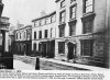
Another offering is the junction of Little Cherry and Cherry...before Corporation St was put through. The corner bottom right being Little Cherry and the road facing being Cherry. If this is the case then the houses facing would be in Cherry propper and would have had the new Corporation Street run right through them. I think I favour this latter and if so what a find. A great find anyway and the houses would have been right at the junction of Cherry St. and Union St. Wiped clean by the new Corporation St.
The corner jutting out at bottom right is right where the Dolcis was to be. Hmmm long gone also.
Anyway; just trying to assemble the few indications available in the picture to make a fit. Use the old Birmingham Improvement Scheme map posted on here.
Many thanks Rupert, makes sense. Think I'll plump for your 2nd suggestion. It has to be a 'T' junction, and the only one on Mike's pre-Corporation St map would be the view taken from Little Cherry Street. If so we're back outside Cherry Street/side entrance to Rackhams/House of Fraser. And of course as you say, this section would all now be covered by Corporation Street. I wondered if this might be a photo taken in the last days of those buildings you see straight ahead. Viv.
Yeah, maybe taking pictures for posterity or for the council to show what would be happening. This photo seems to be a companion to the other Little Cherry St. one also.
Photo's of same row on either side of Corporation St. Just a couple of premmisses missing possibly, that were also removed by Corporation St. From nothing, contributions here can reconstruct a Union St. pretty much...which most of us may not ever have seen. Well...all of us I guess but we would heve seen some of it.
The bollard in the first photo would be the opposite corner of Little Cherry shown at the right of the second photo.
Will have to re-think the location of post #16.
Attachments

Thanks Bernie. The buildings really were tightly packed around this area. The junction with Cherry Street must have been at the top of your photo, but the curve in the road puts it just out of view. I think much of Cannon Street remains as it was then, untouched by the late 1880s Corporation Street development (or even 1960s development) so gives a good idea of the secondary roads and lanes that continued to exist around the new 'boulevard'. Viv.
This extract from the "Colmore Row and Environs Conservation Area Appraisal" of 2006 mentions a little of the development of Cherry Street. If I'm reading this right it seems that it gradually developed as an important link between St. Philip's Church and Welch End/High Street. Cherry Street is described as part of a gated walk. And Walker, the cherry orchard owner, seems to have hung on to some of the land which split the Temple Row ('Tory Row') terraces development.
"A narrow alleyway (Temple Alley, now Temple Row) was cut through from Bull Street to the churchyard gate by the parsonage in 1715 and widened in 1736. Temple Row (St. Philip's Churchyard, Temple Row West) was part of the plan for St Philip's, laid out from New Hall Lane (Colmore Row) to provide access around the perimeter of the churchyard. Some time between 1715 and 1726 Samuel Avery, a bricklayer, and William Westley, a carpenter and joiner, built a terrace of fine houses (Tory Row, Temple Row) to face the church here. The plots were laid out on part of what was then known as Walker's garden or cherry orchard but which had earlier been divided into two closes belonging to the Lamb Inn in Welch End (Bull Street/High Street). Robert Walker, a prosperous gardener, had acquired the property in 1701. The terrace on Temple Row was divided into two blocks by a piece of land retained by Walker. This provided the entrance to a gated walk (part of which is now Cherry Street) leading through the orchard, possibly along the line of the old fordrough or field road, down through the yard of the Lamb Inn to Welch End".
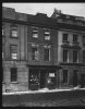
A more recent view (well 1950s) of the junction at Cherry Street and Temple Row. I think the junction must have been close to the original extent of St. Philip's Churchyard (some burials would have been under the road I presume). The church would also have been walled and tree lined and at the highest point of the town. Viv.
View attachment 87417
"A narrow alleyway (Temple Alley, now Temple Row) was cut through from Bull Street to the churchyard gate by the parsonage in 1715 and widened in 1736. Temple Row (St. Philip's Churchyard, Temple Row West) was part of the plan for St Philip's, laid out from New Hall Lane (Colmore Row) to provide access around the perimeter of the churchyard. Some time between 1715 and 1726 Samuel Avery, a bricklayer, and William Westley, a carpenter and joiner, built a terrace of fine houses (Tory Row, Temple Row) to face the church here. The plots were laid out on part of what was then known as Walker's garden or cherry orchard but which had earlier been divided into two closes belonging to the Lamb Inn in Welch End (Bull Street/High Street). Robert Walker, a prosperous gardener, had acquired the property in 1701. The terrace on Temple Row was divided into two blocks by a piece of land retained by Walker. This provided the entrance to a gated walk (part of which is now Cherry Street) leading through the orchard, possibly along the line of the old fordrough or field road, down through the yard of the Lamb Inn to Welch End".
A more recent view (well 1950s) of the junction at Cherry Street and Temple Row. I think the junction must have been close to the original extent of St. Philip's Churchyard (some burials would have been under the road I presume). The church would also have been walled and tree lined and at the highest point of the town. Viv.
View attachment 87417
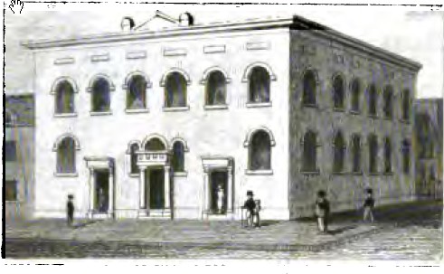
Finally tracked down an image of the Cherry Street Methodist Chapel (from Roy Thornton's Lost Buildings of Birmingham).The first chapel was built in 1782, opened by John Wesley. This was replaced by a larger chapel in 1823, in plain brick, with low pitched roof and a continuous gallery inside. It was demolished in 1886. Looked pretty substantial. Viv.

Last edited:
cookie273uk
master brummie
The artist in post 37 is obviously more competent that the artist in post 40 who appears to be clueless on perspective and scale, so would suggest post 37 is a more accurate image. Only an opinion of course. Eric
