-
Welcome to this forum . We are a worldwide group with a common interest in Birmingham and its history. While here, please follow a few simple rules. We ask that you respect other members, thank those who have helped you and please keep your contributions on-topic with the thread.
We do hope you enjoy your visit. BHF Admin Team -
HI folks the server that hosts the site completely died including the Hdd's and backups.
Luckily i create an offsite backup once a week! this has now been restored so we have lost a few days posts.
im still fixing things at the moment so bear with me and im still working on all images 90% are fine the others im working on now
we are now using a backup solution
You are using an out of date browser. It may not display this or other websites correctly.
You should upgrade or use an alternative browser.
You should upgrade or use an alternative browser.


hi jojo no probs at all posting photos from carls brummagem mag as he is quite happy to share whatever photos he has...the only thing carl asks is if we post any from his birmingham lives archives site that we just put courtesy of carl chinn...here is a link to that site which is brilliant..
https://lives.bgfl.org/carlchinn/search.cfm?mr=
lyn
https://lives.bgfl.org/carlchinn/search.cfm?mr=
lyn
brummie nick
master brummie
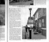
View attachment 84073I've just found this photo in February's Brummagem magazine. I lived in Watery Lane in the 60's and I can't remember this part at all. Does anyone know the answer?
Its down Garrison lane end, I think the shop in the picture was a Butchers.
Nick
mizzyjo
master brummie
Thanks Nick, I was thinking that they must have been demolished by the time that I got there, but now I'm thinking I might never have gone that far down. I turned off a road on the left hand side to take my kids to nursery. I have an idea that Haden's Kettles or Cannings was down there. If you knew that butchers Nick, is there any chance that you know of the bicycle hire shop at no. 216 Watery Lane, on the corner of Keeley Street? That was my grandfathers shop and I'm trying to find some details of it.
brummie nick
master brummie
. If you knew that butchers Nick, is there any chance that you know of the bicycle hire shop at no. 216 Watery Lane, on the corner of Keeley Street? That was my grandfathers shop and I'm trying to find some details of it.
Sorry, I can't help you with info about you Grandfathers shop, I had a schoolfriend that lived in Watery lane, and it was only when I visited him that I went there,
Nick
terry carter
Birmingham Pals
Has anyone got a plan of Tilton Road showing the Terraces and Places that run off it.
Thanks
Terry
Thanks
Terry
Terry
It was not built when thwe c1889 large scale maps were made, so you cannot go to that. The c1970 1:2500 map from the Old maps site does show the names of terraces etc that were extant then, but is difficult to read. My experience of obtaining a bought download from them is that you get soem better resolution, but not a great deal. the original before scanning must have been perfectly legible, but they don't send out a very good scan. I attach a copy of it. However the electoral rolls and directories and what you can see on the 1970 map enable us to insert some of the terraces etc. I have written in those that I can determine on a scanned alan godfrey map of 1901. Of those named, Morrison place and St Andrews both consist of two rows, and the remainder just one row. Hope that is useful


It was not built when thwe c1889 large scale maps were made, so you cannot go to that. The c1970 1:2500 map from the Old maps site does show the names of terraces etc that were extant then, but is difficult to read. My experience of obtaining a bought download from them is that you get soem better resolution, but not a great deal. the original before scanning must have been perfectly legible, but they don't send out a very good scan. I attach a copy of it. However the electoral rolls and directories and what you can see on the 1970 map enable us to insert some of the terraces etc. I have written in those that I can determine on a scanned alan godfrey map of 1901. Of those named, Morrison place and St Andrews both consist of two rows, and the remainder just one row. Hope that is useful
terry carter
Birmingham Pals
Hello Mike
Yes thank you that does help. I take it others such as Tintern, Stanley are on the other side of the road. During WW1 some Tilton road residents worked at Pugh's factory on war work. This would no doubt be situated on the corner of Tilton Road/Cattell Road.
regards
Terry
Yes thank you that does help. I take it others such as Tintern, Stanley are on the other side of the road. During WW1 some Tilton road residents worked at Pugh's factory on war work. This would no doubt be situated on the corner of Tilton Road/Cattell Road.
regards
Terry
brummie nick
master brummie
No Terry, Pugh's was at the other end of Tilton Road past the school.
Nick
Nick
terry carter
Birmingham Pals
Ok Nick. Thanks
I can always remember a factory on the Cattell Road corner. I did not realise there was one past the school.
What did Pugh's manufacture?
Terry
I can always remember a factory on the Cattell Road corner. I did not realise there was one past the school.
What did Pugh's manufacture?
Terry
brummie nick
master brummie
I don't know what they made in wartime, but their main thing was lawnmowers, it was 'ATCO' in later years.
The factory near Cattell Rd was Williams they made spanners.
Nick
The factory near Cattell Rd was Williams they made spanners.
Nick
terry carter
Birmingham Pals
Cheers Nick
brumgum
Proud to be a Brummie!
My older Brother worked at Williams in the seventies, used to meet him outside the factory gate on Saturdays and go and watch Trevor Francis from the Tilton Road End. The wall of the factory formed the back of the stand and there were windows with iron bars and I'm pretty sure some of the workers could see a good part of the pitch from this stand point.Happy Days!:biggrin:I remember Williams,I've got one of their spanners.
Think you can see the factory on one of these shots....
https://carlsbrumblog.blogspot.co.uk/2008_12_01_archive.html

Pat Sattar-Jennings
master brummie
I have a couple of black & white Photos from when we lived in the back house between Cattell Road & Greenway Street in 1970.
I have a couple of black & white Photos from when we lived in the back house between Cattell Road & Greenway Street in 1970.
hi pat and welcome..would love to see those photos if possible..
lyn
i was there in the 60s thanks amazingView attachment 80623 1958.
Tennyson Road overlooking the pool in Small Heath Park.
Tmb73
Brummie babby


 Hi all ☺ I'm a newbie so please be nice!
 Now I realise I'm a bit late to the table here as Bandito's post starts way back in 2009 but on the subject of house numbers for St Andrews Road -
I've recently started researching the family tree and my Great Great Grandparents George and Caroline Fulwell and Great great uncles Harry, George, Albert, Joseph, Thomas, William Great grandfather John Fulwell (there are more but I won't go on) all listed at 5 Whitby place (or terrace ) St Andrews Road in the 1911 census and other documents I have and in the 1901 census the address is 164 St Andrew's rd 18 bk 30. Different houses both in St Andrews Road I presume? 1891 census they are at Adam St.
Will attempt to upload them. .
Welcome to the forum tmb73. Hopefully someone on here will be able to tell you whether the addresses in St Andrews Rd are different (or wonder if they're the same house but were re-numbered at some point?). Enjoy the forum. Viv.
The naming of this court seems rather variable.In the 1920 census it can be seen that Whitby place is between nos 61 & 53 St andrews Road. From 1945 these houses are described as "Back 51". To make it even more confusing (and I think this one must be a mistake on the part of the ordnance survey) it is labelled on the c1950 map as Albert Grove, as can be seen on the map below.
