• Welcome to this forum . We are a worldwide group with a common interest in Birmingham and its history. While here, please follow a few simple rules. We ask that you respect other members, thank those who have helped you and please keep your contributions on-topic with the thread.

    We do hope you enjoy your visit. BHF Admin Team
  • HI folks the server that hosts the site completely died including the Hdd's and backups.
    Luckily i create an offsite backup once a week! this has now been restored so we have lost a few days posts.
    im still fixing things at the moment so bear with me and im still working on all images 90% are fine the others im working on now
    we are now using a backup solution

Old street pics..

Brumgum, i will keep that snowy picture in mind when we have our long hot summers it was about 86degrees today so summer has arrived or so it seems....in the heat of august l'd give my right arm for a snowy back garden, l would never survive without a/c....those videos are great l have something to show my g/children about my roots.....Brenda
 
So many wonderful photos on this thread so thanks to all who take the trouble to revive our memories and give much pleasure thereby.

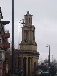
The photo of the Church of the Immanuel in particular is so familiar that I have just checked for its position on the 1914 Birmingham West OS map.

There is a church a short distance from Bishopsgate Street, not named as Immanuel but this must be it, I would think. Am I right?

The photo also shows an area to the left of the church where the buildings were set back and cannot be seen from this view.

I do not remember this site at all; does anyone else know anything about it?
 
Hi Carolina it isn't work I love old pics anyway just post a few that I come across in no particular order some might interest other people but it's a bit of interest on the forum Bernie
 
Elcartermo
Yes that is immanuel. It was merged with parish of St Thomas in 1939 and closed, but St Thomas was destroyed by bombing and it took over. Was finally demolished after 1964
 
Yes still there in the Peace Garden Derek


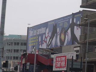
The ice rink / bowling alley on Pershore Street is now the Leisurebox

 
I was travelling that way last week,the old church has been fenced off with danger signs...there were people in the gardens who seem more interested in booze and wacky baccy...sad really....thanks ell.
 
I wonder what the firemen in post 1716 were doing? Love that apart from a few barriers directly by the ladder, rest of the street is open, can't see that happening today!
Sue
 
I was travelling that way last week,the old church has been fenced off with danger signs...there were people in the gardens who seem more interested in booze and wacky baccy...sad really....thanks ell.
Hardly a church surely as little remains but I know what you mean. Sadly the drunks took the gardens over some years back. My wife worked nearby and attempted to walk there with a friend but they did not like the atmosphere. Very sad as I recall visiting many years ago and enjoyed walking around.
 
In a few years time Ell a lot of people will be really grateful to you and all the others that have kept a brilliant photographic record of the city as it has changed
 
Thanks for the confirmation on Immanuel Church, Mike. As for the buildings below and set back, it looks to me as if this was number 192, which,

according to Kelly's 1883 was the premises of Abraham Hoskins, surgeon. By 1892 it was occupied by Charles Edwin Pursloe, MD, surgeon,

and continued to be so at least to 1915.
 
I just like keeping pics of Birmingham up-to-date. Either city centre or suburbs.

Thanks Berniew

St Thomas hasn't been a church since the rest of it was demolished after the war.

Usually the Peace Garden is ok. Although not been there recently.
 
The Gullet started at the junction of James Watt St/Stafford St/Coleshill St. At the eastern end of Dale End. It's the narrow alley just to the left of Stafford St. Probably the upper end was cleared during the Corporation St. construction but it seems that the lower end remained including the buildings in the photo. The map is 1890. The print on the lane says The Gullet but it is not very discernable. There are better maps that show the print better and others pre this one that show the further extent northwards. The No.10 tram past that corner going both ways but I can't remember if it was still there in the late 40s or early 50s. Must have past it so many times. Lnk below. This has all been on here before but probably erased.

https://www.british-history.ac.uk/m...d=10098&ox=2524&oy=474&zm=1&czm=1&x=333&y=243
 
Back
Top