-
Welcome to this forum . We are a worldwide group with a common interest in Birmingham and its history. While here, please follow a few simple rules. We ask that you respect other members, thank those who have helped you and please keep your contributions on-topic with the thread.
We do hope you enjoy your visit. BHF Admin Team -
HI folks the server that hosts the site completely died including the Hdd's and backups.
Luckily i create an offsite backup once a week! this has now been restored so we have lost a few days posts.
im still fixing things at the moment so bear with me and im still working on all images 90% are fine the others im working on now
we are now using a backup solution
You are using an out of date browser. It may not display this or other websites correctly.
You should upgrade or use an alternative browser.
You should upgrade or use an alternative browser.
Witton Lodge Road
- Thread starter Mooch
- Start date
")
dek carr
gone but not forgotten
I Have known this spot since i was a child i never thought of it as a bomb crater more the remains of a Spinney before the houses were built i,m sure it would be easy to prove one way or the other as there are some rather large trees that grow there the question is have they been there longer than the 40s.Dek
horsencart
master brummie
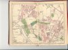
This map show where the bombs landed https://www.goosemoor-lane.com/erdingtonbomb.htm to me it shows that one landed near but not in the spinney
At the far end of Witton Lodge Road ,where the (buzzes) wait, there is a crater in the middle of the road,fenced off. Is this ,as I have always believed ,in fact, a bomb crater ?
Dave M
Pheasey Born Bumper
This map show where the bombs landed https://www.goosemoor-lane.com/erdingtonbomb.htm to me it shows that one landed near but not in the spinney
Might still be
By common consent this is not entirely accurate
Bob Davis
Bob Davis
I was born in Court Lane in 1936 and can remember the spinney being there from when I was three or so and we travelled to 'town' on the 5a. My dad told me it had always been there and had not been built on because when they built the Witton Lodge Estate, they could not build below the top of the hill above the spinney as they had already planned that it would be the turning point for the bus. The 5a was put into the route system once the whole of Witton Lodge Road was complete. Until then the route had been the Perry Common 5 turning at Enderby Road (the Ring). If you study the houses in Court Lane below the spinney and those above, you will see there is an age difference.
Coxhill, the butchers, on Witton Lodge Road. Love the Bull tile on the shop front. Viv.

Bob have you any idea if half way down Witton Lodge Road there was some kind of builders yard .It would have been opposite what was then the recreation ground.I was born in Court Lane in 1936 and can remember the spinney being there from when I was three or so and we travelled to 'town' on the 5a. My dad told me it had always been there and had not been built on because when they built the Witton Lodge Estate, they could not build below the top of the hill above the spinney as they had already planned that it would be the turning point for the bus. The 5a was put into the route system once the whole of Witton Lodge Road was complete. Until then the route had been the Perry Common 5 turning at Enderby Road (the Ring). If you study the houses in Court Lane below the spinney and those above, you will see there is an age difference.
I interested because we just downsized last year from a detached house built roughly in the 1979/80 on where the yard supposedly was. A friend of mine who now longer with us told me that there was a builders or wood yard before building them.
Apparently it had flooded at times and the stream which ran from Kingstanding had to be diverted .It actually runs underneath Witton Lodge Road into what is now part field part housing going onto Witton Lakes and BrookVale park lake.
I don't recall a builders yard, but my dad said there was a swimming pool next to the stream before the prefabs were built.
[/QUOT
Interesting never heard of a swimming baths by the prefabs although I heard if their existence.
In 2012 we had a extremely heavy rainfall which caused a flash flood on the field.
The stream back flowed under the road and caused flooding in the back gardens of houses on the corner of Dovedale and Witton Lodge ROAD.
The back flow was cause by poor maintenence of the stream with foliage and a tree blocking the flow.
They still went ahead and build on the field but had to put in swales think that is how you spell it to take away any other problems that may arise.
Lady Penelope
master brummie
I don't recall a builders yard, but my dad said there was a swimming pool next to the stream before the prefabs were built.
The 'swimming bath' belonged to Oscott College and was part of the recreation programme for the young men training to be priests. They also played 'bandy' up the road in Kingstanding (hence the bandywoods - it was a vicious game). Probably all to work of their excess energy..... The college owned much of the land in that area including the aforementioned spinney.
This is not a very good scan, so Morturn, perhaps you can work your magic and enhance the area of interest. Thanks.
Attachments

Lady Penelope
master brummie
Thanks Morturn.
Bob Davis
Bob Davis
Sorry I don't remember a builders yard, I can only remember all the houses. Has anyone a 1930s Kellys?Bob have you any idea if half way down Witton Lodge Road there was some kind of builders yard .It would have been opposite what was then the recreation ground.
I interested because we just downsized last year from a detached house built roughly in the 1979/80 on where the yard supposedly was. A friend of mine who now longer with us told me that there was a builders or wood yard before building them.
Apparently it had flooded at times and the stream which ran from Kingstanding had to be diverted .It actually runs underneath Witton Lodge Road into what is now part field part housing going onto Witton Lakes and BrookVale park lake.
Bob
A view of Witton Lodge Road at the junction with Capiland Road. Still green fields in the distance (Kingstanding?) so probably dated 1930s. Viv.


There is a thread here of Map Of W W2 BombingIn entry 4 it refers to a map showing where bombs dropped in Goosemoor lane area Does anyone know where this map came from and if there are similar ones for other areas. I'm particularly interested in Slade Road near Abbey/George Road area
Thanks in advance
Birmingham live aslo has this interactive piece Birmingham in the Blitz: Where the bombs fell
The National Archives UK have this photo too. They may have more