Hi. I lived as a child in the mid 1950's at this address (more or less opposite the Roebuck pub). While researching family history, I discovered that the two houses had been demolished and replaced by what was to become a community garden - Richmond Gardens. Sadly these have now been abandoned and are in an overgrown state. It would be great if anyone has any pictures of this property, but I am also curious as to the reason they were demolished ( all the other properties between Richmond and Factory Roads seem to have survived) and perhaps anything of their history (I was always told as a child that they were a part of the Boulton and Watt Estate but can find no records of this owning property). Any information would be gratefully received.
-
Welcome to this forum . We are a worldwide group with a common interest in Birmingham and its history. While here, please follow a few simple rules. We ask that you respect other members, thank those who have helped you and please keep your contributions on-topic with the thread.
We do hope you enjoy your visit. BHF Admin Team
You are using an out of date browser. It may not display this or other websites correctly.
You should upgrade or use an alternative browser.
You should upgrade or use an alternative browser.
97/98 Soho Hill / Richmond Gardens
- Thread starter CAJ
- Start date
Whoops - you're quite right! Thanks. Just looked at an old newspaper article I have and 97/99 it is (Confuing because the Roebuck Pub which was almost opposite seems to have been at 130! Don't know if it's possible to change the thread title but it is 97 I'm particularly interested in as this is where I lived.

Thanks - yes, that's the site. Looks very rural now! In my day that was Mist's Garage directly over the road! Definitely the house on the plot just below BM4426 on the map though so house must have been earlier than this but in the M. Boulton era). It was a very Georgian looking property with a "balcony" between the two houses supported by two pillars. It had quite a lot of upmarket features inside such as stained glass windows and marble fireplaces.

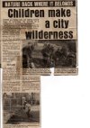
You got it! Sad, isn't it? I believe the site was on the for sale market a while back but is no longer listed. Here's a copy of a newspaper article I have when the gardens were first established (NB they listed it as Soho ROAD rather than Hill)> unfortunately the date had been cut off the article.
The house was far grander than all the others shown which is why I'm curious as to why it didn't survive when all the others have!
The house was far grander than all the others shown which is why I'm curious as to why it didn't survive when all the others have!
Attachments
just caught up with this thread...quite a mystery as to why these 2 houses were demolished..i have passed richmond gardens many times over the years and watched its sad decline...here is a street view from 2009 when it was still looking ok

 www.google.com
Google Maps
Find local businesses, view maps and get driving directions in Google Maps.


oldMohawk
gone but not forgotten
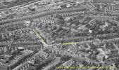
These aerial views dated 1948 might be of interest. In the 1st view Soho Road runs from top left across the view and Hamstead Road from top right. The Roebuck Pub visible on the corner.

The 2nd view from different position.

images source 'britainfromabove' website
The 2nd view from different position.
images source 'britainfromabove' website
brummy-lad
master brummie
Thanks - well I guess it looks OK relatively speaking! Interesting that Mist's Garage seem to have moved on boy this date and that the little corner grocery stores (Mr Stubb's, I seem to remember) on the corner of Hamstead Rd (opposite the Roebuck) seems to have been (recently?) flattened. Houses at Hockey end of the Hill certainly do appear to be more "upmarket" (detached and semi) than those further up. If they were Boulton Estate could they have been for "management?"just caught up with this thread...quite a mystery as to why these 2 houses were demolished..i have passed richmond gardens many times over the years and watched its sad decline...here is a street view from 2009 when it was still looking ok
Google Maps
Find local businesses, view maps and get driving directions in Google Maps.
These aerial views dated 1948 might be of interest. In the 1st view Soho Road runs from top left across the view and Hamstead Road from top right. The Roebuck Pub visible on the corner.
View attachment 177805
The 2nd view from different position.
View attachment 177806
images source 'britainfromabove' website
These aerial views are indeed very interesting. 97 and 99 can be clearly identified as I have a woodcut of 97 made in 1947 and a photograph of my grandfather out at the back at about the same time. These clearly show the long pitch roof outbuildings in the first view! I first thought that the large building to the top left of the photo may have been Soho House which would certainly lend credence to the houses being built on Boulton Land, but of course it wasn't (wrong road - it's Park Avenue, isn't it? and wrong side of the road). I think that Soho House is the part building which appears very top right in Soho Avenue. My second thoughts were that the large Park Avenue property (replaced ages ago by a block of flats) could have been the home of my first school - Handsworth Kindergarten Preparatory School or HKPS as it said on the uniform! Run by a Mrs Bun(n), I believe! Anybody else remember the place, or indeed attend the school in the mid fifties?
Looking at the large relatively undeveloped plot of land running down from (possibly!) Soho House does make me think it could all have been Boulton land.
Looking at the large relatively undeveloped plot of land running down from (possibly!) Soho House does make me think it could all have been Boulton land.
Thanks - I'll check that out. I know that my grandmother lived on in the house until the early to mid seventies when she moved into some sheltered housing just up the road in Rosehill Road. Not sure if anybody else moved in to 97 or if it was torn down just after she left.There is a Facebook page for Richmond Community Garden which shows the history of the garden which goes back to 2002 so the house must have been demolished before that date . So possibly some time in the 1990’s as they had regeneration grants to apply for.
That's tantalising close to showing the front view of the house - if only the resolution wasn't a bit better! Best view I've seen yet though!An aerial view of Richmond Road from 1939, not particularly detailed but still interesting.

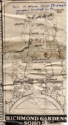
That's great! Coincidentally I had just started looking at Birmingham Council resources myself! So, that resolves the "when" issue but I'm totally intrigued that the building appears to have been listed! Opens up a new can of worms - why was a listed building demolished and why does the case appear to have been taken out of local hands and given to the Secretary of State?Taken from a Planning Committee documaent dated 2nd July 1984
View attachment 177819
At the same time Planning Permission was given for the development of the gardens.
pjmburns
master brummie
I think because it was listed.That's great! Coincidentally I had just started looking at Birmingham Council resources myself! So, that resolves the "when" issue but I'm totally intrigued that the building appears to have been listed! Opens up a new can of worms - why was a listed building demolished and why does the case appear to have been taken out of local hands and given to the Secretary of State?
As the application is so old there are not other documents to explain why permission was given.
I'll have a trawl through listed building records and see if anything comes up there - good to have another potential source of info though my initial question actually seems too be widening now!I think because it was listed.
As the application is so old there are not other documents to explain why permission was given.
This 1979 designation of Lozells and Soho hill conservation area shows an empty site then.I'll have a trawl through listed building records and see if anything comes up there - good to have another potential source of info though my initial question actually seems too be widening now!
Attachments
hi CAJ i have these photos of demolished buildings on the same side near to where you lived...the one showing allports is no 131 the other 2 i dont have numbers for..so close...we do have an extensive thread for soho hill which you may find of interest...just use the search box
lyn


lyn
thanks mike...so near and yet so far to no 97Lyn
The second photo has the one on the left with 127 on the gatepost, so the one to the right of it must be 129 and the far right one almost completely obscured by treees no 131
lyn
RobT
Acemeccanoman
I was at HKPS something like 1950-55 (are you on this photo?) I am not the gent with yellow circle Paul? and he apparently married the girl also yellow circled. Mrs Bunn is on her own at the very back. RobTThese aerial views are indeed very interesting. 97 and 99 can be clearly identified as I have a woodcut of 97 made in 1947 and a photograph of my grandfather out at the back at about the same time. These clearly show the long pitch roof outbuildings in the first view! I first thought that the large building to the top left of the photo may have been Soho House which would certainly lend credence to the houses being built on Boulton Land, but of course it wasn't (wrong road - it's Park Avenue, isn't it? and wrong side of the road). I think that Soho House is the part building which appears very top right in Soho Avenue. My second thoughts were that the large Park Avenue property (replaced ages ago by a block of flats) could have been the home of my first school - Handsworth Kindergarten Preparatory School or HKPS as it said on the uniform! Run by a Mrs Bun(n), I believe! Anybody else remember the place, or indeed attend the school in the mid fifties?
Looking at the large relatively undeveloped plot of land running down from (possibly!) Soho House does make me think it could all have been Boulton land.

That's a great photo - many thanks. Irritatingly, if it was taken while you were there, it's just before my time - I started in 1957. Can you remember if the school was in the building I mentioned in my earlier thread? If that photo was taken in the playground I seem to remember that it was surrounded by trees on dusty earth banks which would probably be called an adventure playground today (or fenced off from pupils in case they had accidents!
Fascinating photos - they're all rather grand houses just like I remember. Number 97 was obviously built in the same period (anyone know when?) and different, but in the same style. The whole area in the triangle of land down from Soho House certainly appears to be quite "upmarket" - Interesting architecture and mainly large houses on big plots. Very different from the smaller terraced presumably workers houses in the surrounding area. Would be interesting if anyone knows more on the history of the development.hi CAJ i have these photos of demolished buildings on the same side near to where you lived...the one showing allports is no 131 the other 2 i dont have numbers for..so close...we do have an extensive thread for soho hill which you may find of interest...just use the search box
lyn
View attachment 177825View attachment 177826View attachment 177827
Oh - and many thanks for the suggestion to have a look at the Soho Hill thread! Brought back many memories and several other "near miss" photos of 97, especially one of Mist's Garage which was more or less the view from my grandmother's front bedroom window!Fascinating photos - they're all rather grand houses just like I remember. Number 97 was obviously built in the same period (anyone know when?) and different, but in the same style. The whole area in the triangle of land down from Soho House certainly appears to be quite "upmarket" - Interesting architecture and mainly large houses on big plots. Very different from the smaller terraced presumably workers houses in the surrounding area. Would be interesting if anyone knows more on the history of the development.