• Welcome to this forum . We are a worldwide group with a common interest in Birmingham and its history. While here, please follow a few simple rules. We ask that you respect other members, thank those who have helped you and please keep your contributions on-topic with the thread.

    We do hope you enjoy your visit. BHF Admin Team

121 Great Brook Street 1917

HannaVictoria

Brummie babby
Would anyone be able to help with precisely where 121 Great Brook Street was 1917. Was it part of a courtyard- or what would have been classed as 'slum' housing?
I'm looking for a Hilda May Turner who had a baby there in 1917- she would have been pregnant, but on her own. She did however have 2 older daughters (but I am not sure if they would have been residing with her or not).
Any help gratefully received :)

Thanks
 
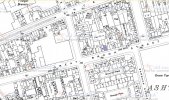
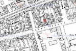
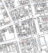
It looks like things were differen tin c1917 than later. Below are maps from c1950 and c1920 with no 121 in blue (ignore red marker). In the c1950 map no 121 is a building on the street. However in the period you are interested in, it is the building at the street-end of a terrace which seems to back onto other buildings,
map  c1950 showing 121 Great Brook St.jpgmap  c1920 showing 121 Great Brook St.jpg
 
It looks like things were differen tin c1917 than later. Below are maps from c1950 and c1920 with no 121 in blue (ignore red marker). In the c1950 map no 121 is a building on the street. However in the period you are interested in, it is the building at the street-end of a terrace which seems to back onto other buildings,
View attachment 157554View attachment 157555
Thank you so much- would you think this indicates it was back to back houses in 1917?
 
It seems to have been in a terrace of houses. Some are backed onto other houses, and some onto other buildings, but the interiors would be expected to be the same in the whole terrace, so yes,
 
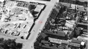
This aerial view dated 1933 shows part of Great Brook Street reference the map in post#3. The arrow points approximately to where the house shaded blue is marked on the map. The building of housing on the barracks was underway at the date of the view.
1933GtBrookSt_Part of.jpg
 
Last edited:
On the 1933 photo there does not seem to be a terrace, and the c1937 map confirms that by this time the terrace has disappeared

map c1937 showing no121 Gt Brook St.jpg
 
On the 1933 photo there does not seem to be a terrace, and the c1937 map confirms that by this time the terrace has disappeared

View attachment 157573

This aerial view dated 1933 shows part of Great Brook Street reference the map in post#3. The arrow points approximately to where the house shaded blue is marked on the map. The building of housing on the barracks was underway at the date of the view.
View attachment 157571
Thank you :)
 
Back
Top