Radiorails
master brummie
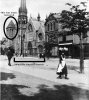
I think the 8 did pass this church. I think the route was from Belgrave Road, a short way along Bristol Road and Sun Street and vice versa.
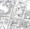
There appears to be no aerial views available for that particular area. It seems that the tower fits but the rest of the building does not. Was this building there between dates 1958 and 1960 when the bus was by the building?Another possible contender Wycliffe Baptist Church or Wycliffe Chapel on the Bristol Road, the tower looks correct. I don't fully understand if they are the same building and the positioning? The map is 1889. An aerial view could help if available. John
This is the latest map I have 1955-56There appears to be no aerial views available for that particular area. It seems that the tower fits but the rest of the building does not. Was this building there between dates 1958 and 1960 when the bus was by the building?
Following up your lead, I've marked the map below.My money at the moment is on Wycliffe Baptist Church, I realise we can't see the windows on the crucial side but the part where the tower is appears to be older than the part to the right. There is what appears to be a cascading effect on the front lower window to the right (perhaps they attempted to match the windows of the newer part to those of the older part in St Luke's Road). St Luke's church looks completely different to later images it appears that the bell tower ? was removed at some stage. On the map Sun Street appears to be at the correct orientation to St. Luke's Road. John


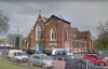
Enlargement of part of your pic seems to show graduated height windows and I can see other features which seem to match the original bus location pic ... probably seeing what I want to see but it looks promising ....Another view of the Baptist Church from Birmingham Library Images, site below..can be zoomed
https://www.search.birminghamimages...D=8137&PageIndex=264&SearchType=2&ThemeID=108
View attachment 131010
")

Following up your lead, I've marked the map below.
Wycliffe Baptist Church on the corner is set back from the road but the Sunday School next to it is directly on the road.
I've marked the tower with a circle and postioned the bus on St Lukes Road where I think it would have to be for the photographer to get the Sunday School in view and the tower showing over the bus. Sun Street is at angle to St Lukes Street which matches the angled street in the original bus photo. More photos of that junction would be useful.
View attachment 131009
Brilliant picture thanks, I think we have our building as another part of the jig-saw was the chimney pots. JohnAnother view of the Baptist Church from Birmingham Library Images, site below..can be zoomed
https://www.search.birminghamimages...D=8137&PageIndex=264&SearchType=2&ThemeID=108
View attachment 131010
Enlargement of part of your pic seems to show graduated height windows and I can see other features which seem to match the original bus location pic ... probably seeing what I want to see but it looks promising ....
View attachment 131011
Old Mohawk, can I use this picture to show as proof of where the bus was. Thank you for all your efforts GEnlargement of part of your pic seems to show graduated height windows and I can see other features which seem to match the original bus location pic ... probably seeing what I want to see but it looks promising ....
View attachment 131011
Hi brummy-lad,Brilliant picture thanks, I think we have our building as another part of the jig-saw was the chimney pots. John


Brummy lad, can I use your picture too, many thanks GHi brummy-lad,
I think you have definitely found it and we can all relax now ...
The matching features I notice shown below ...
View attachment 131022
Hi Banjo, here is a mystery we have never solved and probably unsolvable and I have tried as can be seen in it's thread.Spot on oldMohawk (post #196). I too saw the similarities you pointed out. In my opinion the problem has been solved.
P.S. I enjoyed that saga and all the input, any more photos to investigate?
Is it possible that the tower belongs to the library but the bus is on the opposite side of the junction, i.e. the building on the left isn't part of the library at all, it is just the perspective that makes them look part of the same complex.
It's a church building directly on the road, it's got a tower, it's near Five Ways, but alas not the building we want ...
View attachment 130614
Nice view of a courtyard in top part of pic.
Grea please feel free to use anything I have posted, the images do not belong to me and as far as I am aware there should be no copyright problems. I'm so pleased we have finally identified this building it was quite a mystery wasn't it? very rewarding to be part of the team working on this. JohnBrummy lad, can I use your picture too, many thanks G
Grea please feel free to use anything I have posted, the images do not belong to me and as far as I am aware there should be no copyright problems. I'm so pleased we have finally identified this building it was quite a mystery wasn't it? very rewarding to be part of the team working on this. John
I'm convinced as are a few other contributors that it is the Sunday School attached to Wycliffe Church. The evidence is overwhelming. JohnBrummy Lad Have I missed something has The building been identified ?