• Welcome to this forum . We are a worldwide group with a common interest in Birmingham and its history. While here, please follow a few simple rules. We ask that you respect other members, thank those who have helped you and please keep your contributions on-topic with the thread.

    We do hope you enjoy your visit. BHF Admin Team

Passages, Alleyways Gulletts and Snickets of Old Brum

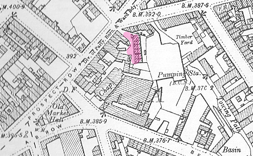
The position of Ashted place has been discussed before. It is not named on any map that I know of, and not in any directory. It is further complicated in that the 1920 electoral roll lists an Ashted place as between 125 and 128 Ashted Row , which, from the 1889 and other maps looks completely unlike the picture, being a straight terrace leading off the street at right angles. However there is also an Ashted Place on the rolls in Gt. Brook St, and this is on the corner of Brook St and Prospect row , and looks very like the picture . Marked in red on the 1889 map and named court 1.
mike

ashted_place_c_1889_map_Gt_Brook_st.JPG
 
Mike I can,t seem to relate to the map at all as there on no streets named where is A.B Row as that was in between Ashted and Prospect Row. Dek
 
Exeter place is the terrace described on the 1889 map as court 3. It is named on the c 1951 map below

exeter_place__map_c_1951.JPG
 
Thanks Mike got it now opposite Holte St I think you are right in your location i seem to remember it now I knew this area in the late 40s- 60s i could never get it in my minds eye that it was on Ashted Row. Dek
 
Mike

Well done locating Ashted Place, although I can remember seeing the sign as a child I could never remember where it was located and I've always wondered about it. So according to the map it was where Great Brook St met the end of Ashted Row.

Phil
 
Dennis, ref post #325. If you go to post #101 (Little Bow Street) you can see those houses in Exeter Place in the distance..behind the wall. Actually those row houses look more than a half decent. Far better than the ones I was used to. I am so glad to have that shot for my collection. Great area for the kids to play in front.
 
Dennis

Thank you so much for these pictures of St Helens passage and Regent Parade etc. They are fascinating to me, as some of my ancestors lived in the back houses off St Helen's passage around 100 years ago.

You wouldn't have any more pictures of this immediate area, would you? If so, I'd be really grateful if you could post them, or let me know where I could get them myself.

Cheers

Pilsbury
 
Mike

One of my relatives tells me the houses in St Helens Passage were also known as Taylor's Building - maybe this explains the discrepancy? Any idea who Taylor might have been?

Thanks

Pilsbury

Not much on Helen's passage. It is not mentioned in Kelly's in 1921, but is mentioned in 1932. It seems to first appear on the electoral rolls in 1927. There is an alley at that position on the 1890 1:2500 OSmap, but it is not named, and it does not seem possible to access the maps on the oldmaps site at present so we cannot see on the 1:500 map if it was known by another name. Searching in google is slightly complicated by the exisenc eof a Helen's passagein Oxford in which Jane Burden (Rosettti's "muse") was born. Other than that the only thing apparently of note about it was the discovery of “birmingham’s biggest cannabis factory” there in 2007
Mike
 
An interesting shot of Hinckley Street before Smallbrook Ringway was developed, plus some more grisly ones from 2009 showing the rear of the Tatler Theatre today looking from t'other end up.


Hinckley St 1961.jpg Hinkley Street 2010.jpg Tatler Theatre.jpg
 
Last edited:
BOWYER STREET, a very narrow Street off Coventry Road is now a dead end and mostly derelict, but used to connect to Adderley Street and you could walk down to the Wagon & Horses if you got chucked out of the nearby Clements Arms.

Bowyer Street.jpg
 
Last edited:
Mike

One of my relatives tells me the houses in St Helens Passage were also known as Taylor's Building - maybe this explains the discrepancy? Any idea who Taylor might have been?

Thanks

Pilsbury

No, but the name rang a distant bell and when I looked at my Family Tree I noted two relatives are listed as living in Taylors Buildings, St Helen's Passage, Vittoria Street. My Aunty Agnes Davis lived there at No 12 from 1920 - 1959 at least. She was a Jewel Case Maker. Then an uncle Thomas Gilbert lived at No 23 in 1891, and No 15 in 1901. All given as Taylors Buildings. Now you've got me fascinated and I will investigate further...cheers Pilsbury.
 
Dennis keep em coming your doing a grand job my Des-res in those days was Vauxhall I only knew Highgate from work experiences.Dek
 
Sorry dek. You know I am nearly gone with the fairies now? I mistake Vaughton Street for Vauxhall. Good job I don't like motor cars much as I would probably be driving a Vaughton Velox by now...
 
Another old fearsome looking WINDSOR STREET, home of another Bevan rellie in 1901. Shiver. Looks a bit bleak out back...

Windsor Street .jpg
 
Last edited:
Both address' mean something to me. My Gt Gt Grandmother and her twin brother were born at 7 Darwin Street in 1851, When she married the early years of married life were at Emily Street. My Grand Father briefly lived in Windsor street, and I grew up during late sixties/seventies off Henage Street.
 
Windsor St now were talking Vauxhall and Duddeston just up the road from our house although i can,t say I remember this Gullett it may have gone by my era. Dek
 
For those who like their alleyways a bit older and Gullet-like...here are some really scary ones, although most are back alley views of more famous Roads or Streets, so they may not strictly qualify, but they scared the hell out of this yellow livered kid...

ESSINGTON STREET, (runs between Ryland Street and Sheepcote Street).


Essington St .jpg
 
Last edited:
And finally, reputed to be from SUMMER LANE. Not 95 where my Aunty Temperance Hicks lived in the 1870s surely....


Summer Lane Back alley.jpg
 
Last edited:
Dennis
Can't find any mention of Evergreen walk, but the court behind no 5 Devon St is presumably it, and is marked in red on the 1889 map
Mike

map_evergreen_walk__devon_rd__1889.JPG
 
Back
Top