spitfire 65
Brummie babby
My gt gt grandmother lived at number 89 according to the 1901 census. Winnie /Winefred Gormley.Wendy on the 1901 census my relatives lived in a court at the back of 89 Staniforth Street, so close.
My gt gt grandmother lived at number 89 according to the 1901 census. Winnie /Winefred Gormley.Wendy on the 1901 census my relatives lived in a court at the back of 89 Staniforth Street, so close.

Yes Lyn. It is
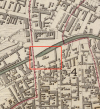
Yes it is....xxdennis is that the ben johnson pub bottom left of the red square...im lost lol
lyn
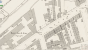
Great old photos! Here's the location from the 1888 Ordnance Survey map. Bagot Court is in the lower middle of the map. The three-hole lav is plainly shown at the western end of the court — CoggoThese photos and information were lost in the recent server crash so are restored here.
Pic 1 (also posted elsewhere on the forum) shows some very poor housing conditions. A wall plaque can be seen on a wall in the street beyond and there are suggestions that it is a war memorial and if for WW1 then the poor housing was obviously there in the early 1920s. There is nothing in this image which identifies the location but the following sequence of photos will.
Pic 1
View attachment 102836
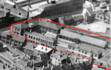
Another view of the buildings and lavatory block in Pic 2, still showing very poor conditions and the edge of the wall plaque can just be seen. The original caption with the pic source suggests it is named Bagot St Court.
Pic 2
View attachment 102837
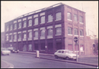
In Pic 3 below the buildings on the right have been reconditioned and the lavatory block demolished. The wall plaque can be seen and also part of an Ansells Pub. Apparently there was a project of reconditioning some slum housing in Birmingham but I have not been able to find any information about it. A close look at the memorial suggests there is a vase of flowers on it.
Pic 3
View attachment 102838
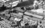
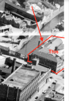
Another view of the the reconditioned buildings and more of the pub showing. Also a street name shows on the pub wall but is not clear in this jpg image. A low tower-like building with a conical roof can also be seen and looks to be part of the pub. The conical roof can be seen in an aerial photo on the 'britainfromabove ' web site.
Pic 4
View attachment 102839
With some photo editing on the original pgn file it reads Staniforth St as shown below, so the pub is the White Hart on the corner of Staniforth St/Bagot St. I've seen this confirmed on an old map but there does not appear to be any available photo of the pub. The house on the right in the previous pics backs on to Bagot St so maybe is why the court is known as 'Bagot St Court'
Pic 5
View attachment 102840

 vintagebicycle.wordpress.com
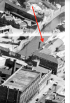
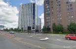
think i would agree that if there was a tower to some sorts it would have been long before 1950...interesting thoughYes, I’ve wondered in the past about the Osmond logo, Lyn. Odd, isn’t it? There was certainly no tower on the site when Hallam, Sleigh & Cheston had the Bagot Street place (see 1950s aerial view). On the other hand, an old 1839 map shows, not surprisingly, a much less developed site with two L-shaped buildings and another structure in the middle. Maybe the middle building featured a tower of some sort. Just a guess, but who knows? — Coggo


 theironroom.wordpress.com
We use essential cookies to make this site work, and optional cookies to enhance your experience.