-
Welcome to this forum . We are a worldwide group with a common interest in Birmingham and its history. While here, please follow a few simple rules. We ask that you respect other members, thank those who have helped you and please keep your contributions on-topic with the thread.
We do hope you enjoy your visit. BHF Admin Team
You are using an out of date browser. It may not display this or other websites correctly.
You should upgrade or use an alternative browser.
You should upgrade or use an alternative browser.
Old street pics..
- Thread starter Astoness
- Start date

Dennis Williams
Gone but not forgotten
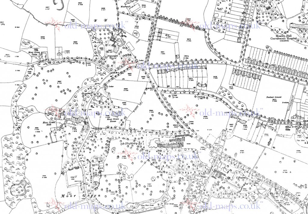
Many thanks lads...good work as per....nice map mike...QUESTION....I'm trying to do a piece on Moor Green and the houses therein...and this one looks a belter...Moor Green Hall...and this is the only ref I can find, courtesy of you Phil I think! I nicked it yonks ago? Anyway, does anyone have a proper shot of this nice building by any chance...or a map of where it was precisely? Ta...

Dennis Williams
Gone but not forgotten
And does anyone know if this lovely old house. which I understand was once a Nursing home of sorts...is still with us in another restaurant, guest house form, on the corner with Cotton Lane....? Ages ago on a past thread ...mike tracked it down to 38 Wake Green Rd....corner of Cotton Lane...I'm hoping it's on Google...or if not, whatever replaced it! Your mission, if you choose to accept...! Cheers...

Dennis
I think it must have been largely rebuilt,in a vaguely similar style, but they still seem to have a very tall chimney at the cotton road end, which might be original. At one time it used to be OK to almost rebuild an old building in restricted areas, provided at least one wall of the original remained.
Moor green Hall can be seen on this c1916 map
Dennis Williams
Gone but not forgotten
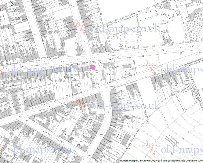
Brilliant...thanks mike...you are a star....and my next query.....this was posted by Tom Burke this morning...on FB...and it is captioned the Moat House, Lyttleton Road, Hay Mills....? Now Lyttleton Rd Stechford I know well....and there ain't no water or stream anywhere near....but Hay Mills....never heard of it? Anyone any clues as to where this might be?

DavidGrain
master brummie
Hay Mills is on the Coventry Road at the southern end of the Small Heath Bypass
Phil
Gone, but not forgotten.
Brilliant...thanks mike...you are a star....and my next query.....this was posted by Tom Burke this morning...on FB...and it is captioned the Moat House, Lyttleton Road, Hay Mills....? Now Lyttleton Rd Stechford I know well....and there ain't no water or stream anywhere near....but Hay Mills....never heard of it? Anyone any clues as to where this might be?
View attachment 96318
Dennis
I have the same photo as you tagged Stechford, but I also have this one tagged Sheldon, I'm willing to bet they are the same house. The map (not a very good one) locates the moat house just down the road from St Giles Church on the other side of the road.
Attachments


Dennis Williams
Gone but not forgotten
Dennis
I have the same photo as you ragged Stechford, but I also have this one tagged Sheldon, I'm willing to bet they are the same house. The map (not a very good one) locates the moat house just down the road from St Giles Church on the other side of the road.
Brilliant deduction Holmes.....I heartily concur.....Hay Mills indeed! A million thanks...I can now be clever on the RB site and everyone will think I'm a genius, instead of you...as per usual...I always take other people's credit.... sigh...it's s burden, but one I've got used to now....!:tranquillity:
and for more info...try this...https://www.facebook.com/photo.php?fbid=1543169045933094&set=gm.584228608375376&type=1
Last edited:
norfolk brummie
gone but not forgotten
Hay Mills is on the Coventry Road at the southern end of the Small Heath Bypass
With the mention of Hay Mills, I recall, around the mid 1940's walking from Sparkbrook to Hay Mills to visit a fair. Is the recreation field still there?
Eddie
bobbynorman
proper brummie kid
yes that' is the same Coleshill Street
devonjim
master brummie
Just up from the junction with Vicarage Rd? Is that All Saint's Church above tree on the right? I was married there Oct 1965.View attachment 96292 All Saints Road Kings Heath

Phil
Gone, but not forgotten.
A busy day in Bradford St, mind you every day was busy in Bradford St at one time. I have a memory about this photo concerning the shop just adjacent to the lead bus. This shop was later a hairdressers shop that was owned by a mate of mine Arthur Brittain, This would have been in the mid to late 60's, did anybody use it?
Attachments
![Camp Hill Bradford Street from City [1].JPG](/forum/data/attachments/19/19910-c5ccd99cfaf0242383c071693b05e960.jpg)
farmerdave
master brummie
The second bus coming up Bradford Street is a number 32. It was one of the routes I could catch, from Hall Green Parade, to go into town. The other main route from there would be a number 37, which would go to Camp Hill and then Digbeth and eventually Albert Street. The lead bus does not have a route number so may be a "short-working". Incidentally, I have a photograph in a book of bus registration CVP 127, which looks exactly like CVP 160 in the picture. So we may be looking at a 1937 DaimlerCOG5/Metro-Cammell 1060. They worked the Birmingham routes for over 20 years. Great picture of Bradford Street. Dave.
Radiorails
master brummie
Bus 1060, CVP 160, was most likely on of the pre-war (WW2) buses pressed back into service, from storage or snow plough duties, when BCT took over some former Midland Red services to New Oscott and other parts nearby around 1957/8 I believe. There were, I gather around 40 of the 1937 Daimler buses involved. They were all withdrawn by the end of 1960. Incidentally bus 1022 CVP 122 had its top deck removed and the lower deck was decorated as the cities Festival of Britain bus in 1951. It toured the city: I saw it in Hall Green. I did get permission from BCT to photograph the bus which was based at Kyotts Lake Road.

mike jenks
master brummie
Hi
It only seems a moment ago. Circa early 50's boarding a no 53 at Stechford/Terminus. A new JOJ.
Best buses ever.
Mike Jenks
It only seems a moment ago. Circa early 50's boarding a no 53 at Stechford/Terminus. A new JOJ.
Best buses ever.
Mike Jenks
irene floyd
master brummie
Hi All.Any pics of CARLTON AVENUE off CLIFFORD STREET my nan n grandad lived at number 8 Carlton Avenue.Thanks Irene

Phil
Gone, but not forgotten.
View attachment 96474Came across this today anyone any idea where the Manor House Green Lane Small Heath was I have looked on the couple of 1880 maps I have but I can't find it
Bernie,
Could it possibly be Bordesley Grange that was opposite the junction of Grange Rd & Green Lane?
Dennis Williams
Gone but not forgotten
This is from an old Small Heath Local History 'Book' "ABC of Small Heath and Bordesley Green" by Bob Marsden, a local historian - from 1987....
hope it helps....

hope it helps....
Dennis Williams
Gone but not forgotten
Cheers Lads well done Dennis Bob's a better historian than he was barber do you remember his shop on Bordesley Green by Carlton Road
No sorry Bernie...I used Tony East in Albert Road, Stechford....! But Bob's books are ace...although the photos are not much bottle, but the text is good, if a little primitive! And thanks to mike and Phil for their input..
Phil
Gone, but not forgotten.
Highfield Rd, Edgbaston c1966, when I first saw this I asked myself why would a number 8 bus be in Highfield rd. It was then that I realised that it must have been due to a diversion, perhaps the building of the Five Ways underpass. Was it as early as 1966?

