-
Welcome to this forum . We are a worldwide group with a common interest in Birmingham and its history. While here, please follow a few simple rules. We ask that you respect other members, thank those who have helped you and please keep your contributions on-topic with the thread.
We do hope you enjoy your visit. BHF Admin Team
You are using an out of date browser. It may not display this or other websites correctly.
You should upgrade or use an alternative browser.
You should upgrade or use an alternative browser.
Bridge Street/holliday Street Old House
- Thread starter vanessa
- Start date
Just broken into a mini panic reading this
https://www.millerdevelopments.co.u...e%20of%20Arena%20Central%20Redevelopment.aspx
Is the Arena development on the other side of Bridge Street to our little treasure discussed on this thread? ( i.e. does it include both sides of Bridge Street? Does it affect the Bridge Street building?) In any case, I think it might be worth keeping an eye on this given we've not found any listing for the building as yet. Could be a false alarm, but you never know do you? Viv.
Sent from my iPad using Tapatalk HD
Hi Lyn. Will post the pages as attachment. It's about the demolition taking place as part of the Arena Central development. Hopefully it won't include the building on Bridge Street, but I'm not sure. Web page is dated 2012, so some of the development must have started, but it won't all finish until 2015. V.
Sent from my iPad using Tapatalk HD
Sent from my iPad using Tapatalk HD
Attachments

oldMohawk
gone but not forgotten
sospiri
GONE BUT NOT FORGOTTEN
From https://bigcityplan.birmingham.gov.uk/map-of-enterprise-zone/ this appears to be the limit of the Enterprise Zone, and if I am not mistaken, our building is not involved:-

There's a more detailed map here:- https://bigcityplan.birmingham.gov.uk/wp-content/uploads/2012/12/Site-Map-Arena-Central.pdf
If you blow this latter map up to 400%, the building has the number 19 (upside down) on it. Anyone any idea what this indicates?
Maurice
There's a more detailed map here:- https://bigcityplan.birmingham.gov.uk/wp-content/uploads/2012/12/Site-Map-Arena-Central.pdf
If you blow this latter map up to 400%, the building has the number 19 (upside down) on it. Anyone any idea what this indicates?
Maurice
That's good Maurice. It's right on the edge of the development. I think the map must be from a report or document and the number 19 might be a reference in the document. If only we could find out the document name we might get some info on our building. Looks like a City of B'ham doc. Will have a nose around. Thanks for putting our minds at rest! Viv.
Sent from my iPad using Tapatalk HD
Sent from my iPad using Tapatalk HD
sospiri
GONE BUT NOT FORGOTTEN
I'm fine thank you Lyn, just enjoying this little quandary, and spent a few hours digging through planning applications and canal websites and forums. Nothing really positive, but have been able to rule out things like toll offices. There are plaques for everyone of those! It has the look of a small institution, but it would be a strange place to put a school, orphanage or something like that. In the end it might end up with one of you local bods walking down to the Planning Office and asking. They will never give you the name of the owner, but they might tell you what they refer to it as. Even the local police station might know.
Maurice
Maurice
You can stand down Lyn. We won't be sending you off on one of our special missions on this one! But be good to find out a bit more. If anyone stays at the Premier Inn next door, maybe they could do a bit of poking around for us! Be good to get a few close up pics of any features on the building. Who knows even the hotel may have info (mmm .... thinking again, probably not). Viv.
Sent from my iPad using Tapatalk HD
Sent from my iPad using Tapatalk HD
Ladder, Lyn? That's a sure way to get a bit of assistance from the local cop shop!
Maurice
my thoughts exactly maurice but its got to be done..if i get caught can you arrange a forum whip round to bail me out please..

Thanks for all your interest. I'm new to the site and just put my comment down hoping for a bit of info. It's wonderful to know you're all out there taking an interest. I shall definitely go and have a proper look when next in Birmingham. As I said at the start of this thread I'd only spotted it from the canal and just guessed at where it was exactly from aerial photos and google street view. Vanessa.
hi vanessa and thank you for bringing this building to our attention..this is what we need on the forum..folk taking an interest in our history and now that you have i bet collectively we will leave no stone unturned to try and find out more about it so watch this space...
thanks again
lyn
thanks again
lyn
")
sospiri
GONE BUT NOT FORGOTTEN
I'm having a guess here, but perhaps those more knowledgeable than me can confirm or discount this. How about The National Association of Canal Carriers?
Here's Bridge Street in the 1936 Kellys:-


The saw mills was presumably Williams and Farmer.
The Association seems to have gone out of business or been absorbed into some other organisation as what few entries there are on the net relate to 1939/1940.
The same address has The River Severn Development Association and the Severn & Canal Carrying Co. Ltd.
According to the London Gazette, the Severn & Canal Carrying Co. Ltd. was put into liquidation in 1985.
Some further information about The National Association of Canal Carriers. It wasn't created until 1933 when the Cheltenham Chronicle dated 23 September reported that Mr J. Ironmonger of Fellows, Morton & Clayton was elected provisional chairman and Mr E.W. Baylis of the Severn & Canal Carrying Co Ltd was temporarily carrying out the duties of secretary. I have not found anything to suggest that the activities of the Association extended beyond 1940.
Here's the Committee membership in 1938. George Cadbury represented the Severn & Canal Carrying Co Ltd.

Maurice
Here's Bridge Street in the 1936 Kellys:-
The saw mills was presumably Williams and Farmer.
The Association seems to have gone out of business or been absorbed into some other organisation as what few entries there are on the net relate to 1939/1940.
The same address has The River Severn Development Association and the Severn & Canal Carrying Co. Ltd.
According to the London Gazette, the Severn & Canal Carrying Co. Ltd. was put into liquidation in 1985.
Some further information about The National Association of Canal Carriers. It wasn't created until 1933 when the Cheltenham Chronicle dated 23 September reported that Mr J. Ironmonger of Fellows, Morton & Clayton was elected provisional chairman and Mr E.W. Baylis of the Severn & Canal Carrying Co Ltd was temporarily carrying out the duties of secretary. I have not found anything to suggest that the activities of the Association extended beyond 1940.
Here's the Committee membership in 1938. George Cadbury represented the Severn & Canal Carrying Co Ltd.
Maurice
Looks promising Maurice. Whilst we all ponder Maurice's info about the Severn Canal Co - and it's looking promising to me. I think it would be well worth the effort to find out more as much of the area looks to have been completely re-developed in recent years, so working out what this one row of buildings is would be lovely. Might be a red herring, but I also wondered whether the Birmingham Central Goods Station had any connection, as I seem to remember reading that they bought up quite a bit of land around here. Obviously this would be later, maybe when the canals became less commercially viable in favour of rail freight. Viv.
Sent from my iPad using Tapatalk HD
Sent from my iPad using Tapatalk HD
Lyn
Sorry I have only just got back to you. I was a bit shattered after my trip. I have realised that one of the maps c 1950 (well immediate post-ww1, though am not sure of exact date) that I have recently acquired, covers this area. I attach it. You will see, as you have already concluded, that no 16 is further uo the street. Also that the cottages are marked with no 19. I think this is likely to be 19 & 20, for reasons that follow. you will see from some of the buildings higher up, that not all buildings are numbered (presumably so it does not get too cluttered. Looking at the electoral rolls I found that in 1922 19/20 Bridge st lists Walter & Alice Harris.
1925 19 Bridge St Walter & Alice Harris
1930 19 Bridge St Walter, Alice and Elizabeth Mabel Harris, Dorothy Caroline Campion and Roy Bertram Cole
1935-1939 19 Bridge St. Arthur Henry & Esther Connie Warner
1945 19 Bridge St William E., Amelia & Alice M. Greaves,
1947- 1962 19 Bridge St Joan M. & Harold Partridge
1965 19 Bridge St Frank West
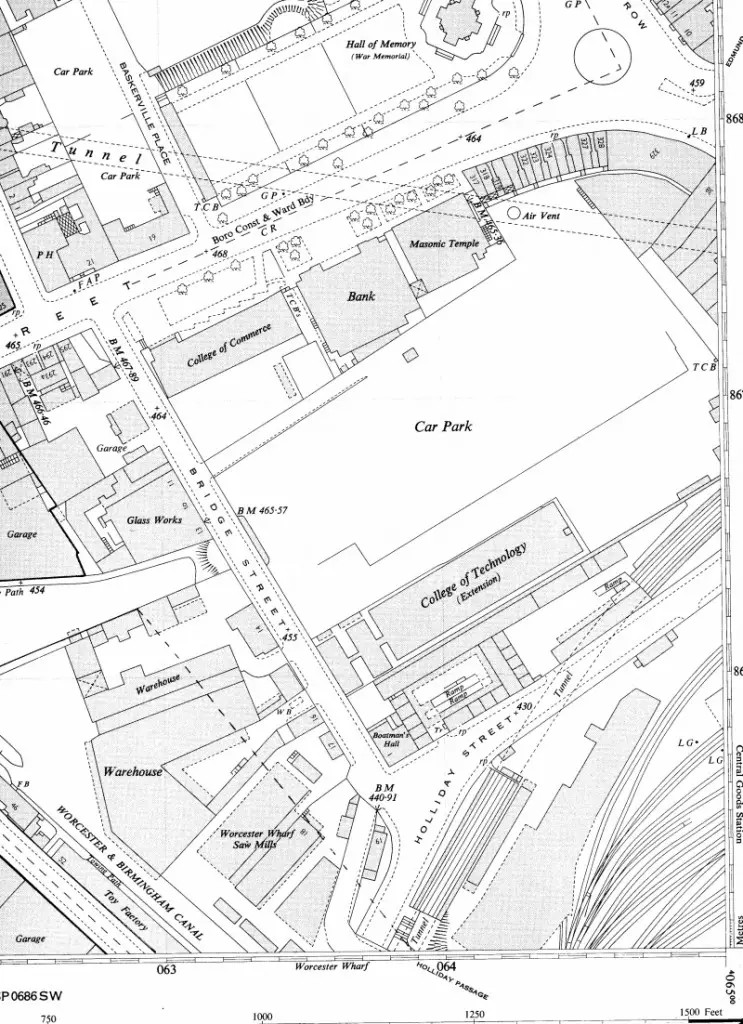
That's good. We now know in the 1920s they were cottages .... but were they prior to 1920 ? Were they originally built as domestic premises? Viv.
Sent from my iPad using Tapatalk HD
Sent from my iPad using Tapatalk HD
fantastic map mike..i checked the rolls as well and found a number 16 which i thought could be the building but as your map proves it was no 19 must say i always thought it must be a domestic dwelling simply because of the chimneys lol..now to find out who owns it and what if any plans there are for the building...thank you mike you are a star with these maps..ps do hope you and mom enjoyed your day out...
lyn
lyn
Still have a nagging doubt about it not being totally domestic. We know it was domestic by the 1920s but I still think they originally had another purpose to do with the canal and commercial activity. I expect to be proved wrong (!) but it's interesting to explore the details and possibilities!
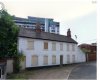
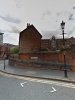
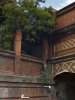
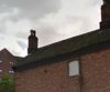
Anyway I had a close up look on Streetview and looking at the structure of the building(s) it would have originally been a longer terrace. You can tell by the positioning of the chimneys. There is an exposed chimney breast on the end, which must have originally been contained within a longer terrace of cottages. The central cottage has many windows, whilst the two end cottages had only one up and one down. The end cottage windows are much larger than the central cottage. Why was the central cottage so big? The space left by the 'lost' cottage has just been bricked across to join the boundary brick wall. Both ends of the terrace have small side gates in the wall - onto Holliday Street ? - as the terrace doesn't appear to have gardens as such. Why were there side gates onto Holliday Street. For quick access? The area behind the terrace appears to be a tiny space so was it a walkway?
The boundary wall behind the terrace is in the same style as the aqueduct bridge on Holliday Street, so I wonder if the terrace probably dates between the 1790s to 1815. Would these cottages have been built around the same time? The boundary wall curves around the terrace and ends on Bridge Street, where there looks like there might have once been a gated entrance.
The one feature that I find very odd is the rear window. Why only one? Why so high up? Maybe to view the traffic coming up the canal?
Just for info the Premier Inn address is now #20.
Viv.
Sent from my iPad using Tapatalk HD
Attachments
-
 ImageUploadedByTapatalkHD1382688187.676181.jpg61.6 KB · Views: 27
 -
 ImageUploadedByTapatalkHD1382688196.730219.jpg166.3 KB · Views: 28
 -
 ImageUploadedByTapatalkHD1382688218.779499.jpg221.4 KB · Views: 27
 -
 ImageUploadedByTapatalkHD1382688235.154444.jpg188.1 KB · Views: 27
 -
 ImageUploadedByTapatalkHD1382688246.897424.jpg17.8 KB · Views: 25
Vanessa,
I hope you'll be kind enough to visit Lyn when she's serving her sentence. It's a bit far for me to go!
Maurice
I'm sure I will.......!!!!!!
OuterCircleBus
master brummie
I’m reading the speculations about the “houses” on the corner of Bridge Street & Holiday Street with great interest. I have no great knowledge on the subject but thought that I’d air my opinions here.
In the 1828 & 1832 maps Bridge Street does not extend as far as the present line of Holiday Street and in fact turns sharp east into Wharf Street which no longer exists. There seems to be footpath with a tunnel under the canal which goes through to Gas Street, which as we know now turns sharp west almost at a level with the canal. Therefore I suspect that the building was not there in 1832 as there is nothing at this angle on either map.
Holiday Street was cut it seems at a date later than 1832 and required a great deal of excavation to get the level down low enough for road traffic to get under the canal. Does anyone know when Holiday Street appeared on the present line?
If the building was erected between 1832 and 1876 and it was for domestic use was it built as a “blind back”? Hence the lack of windows to the rear.
I speculate that it was built for canal, saw mill or wharf staff and to a standard of an industrial or commercial building, possibly the larger one for the wharf or saw mill manager & the smaller ones for other members of staff. This may explain why there was one window at the rear so the manager could, as others suggest, watch what was going along the canal to the south. The commercial nature of the structure will probably explain why the building is still there. The Back-to-Back houses in Hurst street were built around 1830 to a very low standard and at the time of the renovation in 2001 were at the point of collapsing into Hurst Street, in fact the company responsible for the renovation had to take drastic measures to prevent a total collapse. Commercial buildings for residential purposes, such as station master houses, were usually built to the same standard as stations, municipal buildings etc. therefore would be expected to have a long life if treated well.
Maybe taking a closer look at maps later than 1832 would give a clue as to when Holiday Street and the bridge appeared. If the “houses” were built before the Holiday Street cutting this may explain the closeness of the wall to the back of the building.
My Birmingham map of 1902 shows both Holiday Street and the building in place so they were certainly there by then.
Does anyone else have a similar opinion or fill in the gap?
I hope that my musings are of a little help!
OuterCircleBus
master brummie
I look forward to seeing if we get any further forward and maybe see this building alive again!
