• Welcome to this forum . We are a worldwide group with a common interest in Birmingham and its history. While here, please follow a few simple rules. We ask that you respect other members, thank those who have helped you and please keep your contributions on-topic with the thread.

    We do hope you enjoy your visit. BHF Admin Team
  • HI folks the server that hosts the site completely died including the Hdd's and backups.
    Luckily i create an offsite backup once a week! this has now been restored so we have lost a few days posts.
    im still fixing things at the moment so bear with me and im still working on all images 90% are fine the others im working on now
    we are now using a backup solution

Witton Road

Dirty Habit

proper brummie kid
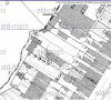
I recently got myself a 1913 OS map showing my old house at 3/146 Witton Rd. Can anyone tell me what the long strip of land may be that runs right across the map and has black dots along it.... is it a boundary or pathway.
Our house was unusual as it only had windows and a door on one wall, just as a child might draw a house. The land either side were part of long gardens that were belonging to houses on Witton Rd. But on the map it shows that there was a piece of land directly behind our house (house marked in red and land blue) I am wondering if it may have been part of our property as it is the same width as the house and is between the path or boundary.
Allenold house.JPG
 
Below is a view from the earlier c 1889 larger scale map, which is a bit clearer. The feature you are asking about is two things. the dotted line is a ward and county boundary. If you follow it up to by Trinity road, it says Parly.Boundary, and further on it says Union,parly,county .ward Bdy. This boundary is, as often happens placed in the centre of a stream, which probably was no longer there when you knew it. The larger scale map shows an abbreviation CS, which stands for "Centre Stream ". This abbreviation is from "Ordinance survey Maps" by Richard Oliver
 

Attachments

  • map c 1889 stream  & boundary off witton Road.jpg
    map c 1889 stream & boundary off witton Road.jpg
    76.9 KB · Views: 0
Last edited:
Than you mikejee, That is a much clearer and detailed map, it even shows the two protruding bay windows on our house. I also see that the shop we always knew as "The Wool Shop" was at sometime a Post Office.
 
Back
Top