• Welcome to this forum . We are a worldwide group with a common interest in Birmingham and its history. While here, please follow a few simple rules. We ask that you respect other members, thank those who have helped you and please keep your contributions on-topic with the thread.

    We do hope you enjoy your visit. BHF Admin Team
  • HI folks the server that hosts the site completely died including the Hdd's and backups.
    Luckily i create an offsite backup once a week! this has now been restored so we have lost a few days posts.
    im still fixing things at the moment so bear with me and im still working on all images 90% are fine the others im working on now
    we are now using a backup solution

St James The Less Church Ashted

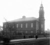
pmc1947. I remember it as you describe, an entrance of steps going down with a concrete slopping cover ( just like one in Coleman Street outside the Salvation Army.) We thought it was to the burial vaults, it may well have been because I remember little chambers at the sides of the passageway.I only remember going down there once but I certainly remember it and I was spooked by the place. At the bottom of the steps a passage went to the right and seemed to run under the floor of the church.

Ernie,

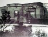
Perhaps the crypt was utilised as an air raid shelter, because as I understand it on the night it was bombed people were trapped for a while in the crypt where they had sheltered from the bombing. At least I thought I read that somewhere.

So perhaps we are both right, it was a shelter and it was a crypt.

Phil
 
pmc1947. Phil I am sure that you are correct in what you say.
Its nice to read about what you were saying and helps to drive away those spooks somewhat from years ago. As I said I only went there once and that was enough for me. I think that things stay with you from years ago like the witch's cottage near the start of Church Walk across the road from Ward End park. At least thats what I heard and still seem to believe to this day, and the
ghost of a woman climbing the stairs ( no longer there ) of Whitley Court all those years ago. Hopefully I have no more spooks I can think of.
 
Those last pictures ring a bell, because I remember seeing the remains of the roof a day or two after the raid from a passing tram - it was quite sensational, because it was hanging from the ends - as timber-framed roofs do. The fire brigade must have got there soon enough to prevent the timbers from burning away.
As for the church itself, I think we have said before that is supposdred to have been converted from the big house of Dr John Ash, founder of the General Hospital, who let out his land for the development of the Ashted Estate when he moved to a more congenial life in Bath. It's an interesting story.
Peter
 
St. James Ashted

Di Poppit, thank you for posting the St. James, Ashted photo...another one for my files. Georgie
 
So where was this church then? My dad knew of an Ashted Row (which no longer exists either). I've just discovered that my granddad was baptised there.
 
Darthdc

It was in Barrack St, and Barrack st ran from Great Brook St to Vauxhall Rd.

Phil
 
Darthdc

As far as Ashted Row no longer existing, that is true but the last time I was down that way the street name plate "Ashted Row" was still on display fixed to the Dog and Partridge Pub.

Phil
 
Rupert
If you look on the mapseeker website at the 1834 map of birmingham (reproduced in part below), you can see that the church (marked 13), is a little over from Vauxhall gardens. In the 1839 map much of the gardens have gone,, but some remain, and by 1851 they have all gone
Mike


E-mail_Map_Barracks_area_1834.jpg
 
Mike, thanks for posting. Your map shows the gardens in a different place completely and my interpretation of the drawing seems to be wrong. Hmmm. back to the drawing board.
 
Hello list

Would this be St James Church, Aston, Birmingham does anyone know? If so thanks very much for the photos JKC.

Best regards
Sian
 
Hi Wendy and thanks, someone has gone to a lot of trouble but much appreciated by researchers.

Thanks again.
Sian
 
I have an address of St James Street on a marriage certificate (1843) would this have been in the area of this church if it was would it have been an affluent area or working class. Thank you.
 
dottieau

St James St was on the edges of the grounds of St James church on Barrack st Nechells. I think it was a working area as most of the area was except for a few streets.

I think Dek Carr used to live in St James St, at least I think it was him.

Phil

Vauxhall.jpg
 
Dottieau,Sorry to say it was a very poor area I lived not in St james St But right opposite in Erskine St ,I remember the houses though The St. was no more than a 100mtr long there were houses all the way down the one side some had little front gardens, some didn,t.The other side had houses with no gardens all the way up till you came to the church yard wall you can still see this wall when you go up Barrack st this is all that remains of St James St.many a happy time was spent playing with my friend who lived at no 19. Dek
 
Here is a link to the 1890 survey map for this area. If you have a wheel mouse you can hold down control and rotate the wheel to zoom. By klicking off centre on the map you can move the clicked point to centre and thus move around on it. Not up though it is at the top of the page already. St James Rd. is gone but you can still see on Google Earth the wall mentioned and the area where the church was on Barrack St.
Erskine is still there and curiously so is Vauxhall Grove where the houses seemed to have been upper class at one time with large front gardens fronting on the grove...before our time and have not seen any pictures yet but the rear of the houses can be seen on the drawing of Vauxhall Gardens and also Erskine Street when there were no houses at all...just a field that the big houses backed on to.

https://www.british-history.ac.uk/m...id=10098&ox=4600&oy=216&zm=1&czm=1&x=390&y=96

This area was Upper Class at one time and there were some large row houses at the end of Great Brook Street but it was all lost to the expanding need for industry and the railway cut Vauxhall gardens in half, separating it from the Rea. Lower quality row housing became the norm and the larger Upper class ones fell into decay somewhat which is the way that we would remember them. Phylis Nicklin had some lovely pictures and one was of the larger houses at the end of Great Brook Street which has all but dissappeared.
 
Thank you all for your replies The gentleman living in St James street in 1841 I thought he may have been quite well off as his occupation was a gentleman.The descendants of this line stayed around this area and they were working class some working for the railways. Thanks for the map its good to get a feel for the streets finding the names on census forms.
 
There is more information on this imediate area on this forum. If you go to 'Search' at the top of the page and type in 'Gosta Green Through Duddeston' and press go. The thread has many pages but some of those of interest may be P86 #851.
P105 #1041...P104 #1037 and #1038.

The map ref on #1041 is the leaf above the one posted here and Great Brook Street that runs diagonally from bottom left to right. The Phylis Nicklin photo is looking towards Vauxhall Road (the one with the tram line) along Great Brook. Those large row houses would have been rather grand in the times of the Gardens I think. Vauxhall House would be where the Union offices were on the 1890 map (may have been the same building) and would have been located exactly where the Gardens gate is before 1850, just above the V at the bottom of the sketch. So if you look at the Nicklin photo and envision a wraught iron gate and fence on top of a low wall instead of the houses at the end of the street on the far side of Vauxhall Road...a stand of trees to the left of and at the gate and a smooth bowling green beyond...that would have been the scene before 1850 or so. I don't know when the large houses on the laft of the photo were built but they may have been there towards the end of the gardens presence.

The data base is very large now and interested new members may not have seen this info.
 
Rupert I would like to say thank you on behalf of 'The Team' for taking the time to point out the thread and finding those page numbers/posts for dottieau.
As you say it is now a very large thread with so much info' on the area that if you are unsure of what to look for it can be daunting for new and even some of our long time members who find it has become an area in Birmingham of interest to them.
Thanx again and also to other members who help on the forum pointing folk to info' already there, but maybe hard to find if unsure of what to look for, or unaware that it's there already..

Chris/Pom :angel:
 
Thank you Rupert for taking the time to find me all that information it is so interesting I have really enjoyed going through the Gosta Green Duddeston pages. I really love the old photos thanks again.
 
OK, thanks. I find the travels by Pye in the following link to be very informative of older times. Written, it is said, in early 1800s and is so easy and pleasureable to read. Anyway I have included a couple of pertinent passages to this thread here. The Crescent referred to is Alma Crescent which never became what it was originally ment to be...upper class residences looking out over a rural Saltley plain and Washwood Heath. The travels would have been made by horse drawn coach over dirt and cobble roads. There is much information in this link and many places around Brum are described. Lots on coach and canal boat schedules too. The title Modern Birmingham refers to Modern at the time of around 1800. The map posted by Mike on #41 this thread would be the closest to this time perhaps. I think that you can see the outline of some of the houses in Phylis Nicklins photo just prior to the houses at the end of Great Brook Street on Mikes map. The houses at the very end of the street were yet to be replaced back then as were the ones on Ashted Row.

https://www.fullbooks.com/A-Description-of-Modern-Birmingham1.html


_Duddeston or Vauxhall,_

So called after that place of fashionable resort near London, is
little more than a mile from the centre of the town.

This was the ancient residence of the Holt family, and within memory
contained some good paintings, as the gardens did a number of lead
statues, large as life, and some smaller ones; but depredations being
committed by stealing some of them, the others were removed.

These delightful gardens, which contain a very spacious bowling green,
an orchestra, a great number of commodious gravel walks, on the
borders of which are numerous lofty trees, of various kinds, together
with parterres, where flowers of different sorts were accustomed to be
seen, were, till of late years, resorted to by none but the genteeler
sort of people, and from their retired situation, are every way
capable of being made one of the most rural retreats for public
amusement of any in the kingdom. Times are now completely changed, it
being turned into an alehouse, where persons of all descriptions may
be accommodated with that or any other liquor, on which account the
upper classes of the inhabitants have entirely absented themselves.

By adopting this method, the editor is of opinion, that the
present occupier is accumulating more money than any of his
predecessors.--There are, during summer, fire works occasionally
exhibited, and sometimes concerts of vocal and instrumental music.

_The Crescent._

Several years have now elapsed since a plot of ground, 1182 feet in
length, forming a terrace seventeen feet above the wharfs, was laid
out for the purpose of erecting some superior buildings in that form,
and the wings were soon after constructed according to the plan; but
as yet very little progress has been made in the central buildings.

_The Barracks._

In the year 1793, government took a lease of five acres of land, near
Ashsted chapel, at the rate of one penny per square yard, whereon
they expended the sum of thirteen thousand pounds, in the erection
of barracks to accommodate one hundred and sixty-two men, with their
horses.

_To Coleshill, distant ten miles, on the road to Atherstone._

You leave Birmingham through Coleshill-street, and having passed by
Ashted-row, you perceive the lofty trees in Vauxhall gardens, which
must be left on the right hand, and a few hundred yards afterwards,
keeping the right hand road, you pass by, on the right, Duddeston, an
elegant pile of building, the residence of Samuel Galton, Esq. but it
is scarcely discernable, on account of the shrubberies by which it is
surrounded. You now pass through the village of Saltley, and at the
extremity, on the left, is Bennett's hill, where Mr. William Hutton,
the venerable historian of Birmingham resided, and ended his days.
 
Thank you Rupert its hard to believe that the Duddeston/Saltley area was ever like this. I never knew this area just passed through on the bus and of course it was very run down in those days.But its been good to read of how it was all those years ago.
 
Re: St James the Less Ashted

what a lovely read of these posts and some fab photos thank you all.
This has given me some leads into the smith family history.
All of my husbands smith family were born in no 6 court vauxhall rd.
My husbands father thomas (1595 RWR) and his brother and sisters were all born in this court but some in different houses.
The reason being the parents,(Smith) grandparents (Wilcox)and great grandparents (Ingram) appeared to live in the court as well.

My husbands grandparents (smith) were married at the Bishop Ryder church.
This is where I am stuck as Thomas's father Albert Edward Smith is eluding me. (on alberts marriage lines he is supposed to be 23 yrs old and his fathers name is also Thomas)
I have recently found an entry for an A E smith as being christened at St James the Less on the 21 /07/ 1867.
His parents appear to be Thomas smith and Phoebe Smith. My question being are there any listings of this church in Birmngham Library.
I also know my Albert Edward Smith died after the 1901 census but before 1909. (his wife died in 1909 and is a widow)
Any help would be so appreciated.
 
I have just downloaded two christenings from the Familysearch.org site, one at St james the less in Ashted, the other at St Nicolas, which I think was in Lower Tower street, unfortunately the photos on here have disappeared due to the hacker. Does anyone have copies of the photos of Saint James please? Having looked for photos of St Nicolas, I'm not sure if any turned up.
 
Here is one I have I think it may have come from here originally.

St_James_the_Less_Ashtead.jpg
 
Last edited by a moderator:
I believe there are several photos of St James's on the Gosta Green through Duddeston thread, but here are a few more. One of St James's in its former glory, one of it after the bombing in WW2, and one of the site I took in 2008. I've also added a photo of the St James Sunday school at the top of the middle section of Francis St on Henry St for good measure.

Phil
 

Attachments

  • St James the Lesser Barrack St Ashted.jpg
    St James the Lesser Barrack St Ashted.jpg
    97.1 KB · Views: 58
  • Nechells St James the Less (shell) Barrack St .jpg
    Nechells St James the Less (shell) Barrack St .jpg
    168.2 KB · Views: 49
  • Site of St James Barrack St Nov 2008 .jpg
    Site of St James Barrack St Nov 2008 .jpg
    242.8 KB · Views: 51
  • Nechells St James Sunday School Henry St .jpg
    Nechells St James Sunday School Henry St .jpg
    93.3 KB · Views: 54
Back
Top