• Welcome to this forum . We are a worldwide group with a common interest in Birmingham and its history. While here, please follow a few simple rules. We ask that you respect other members, thank those who have helped you and please keep your contributions on-topic with the thread.

    We do hope you enjoy your visit. BHF Admin Team
  • HI folks the server that hosts the site completely died including the Hdd's and backups.
    Luckily i create an offsite backup once a week! this has now been restored so we have lost a few days posts.
    im still fixing things at the moment so bear with me and im still working on all images 90% are fine the others im working on now
    we are now using a backup solution

Saltbox hamlet

Vivienne14

Kentish Brummie Moderator
Staff member
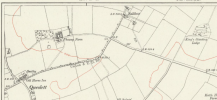
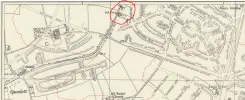
Not a place I’d heard of until today. It was roughly somewhere in the region of Perry Common, Kings Rise, Warren Farms. And according to Bill Dargue it was

“.... a hamlet off Queslett Road, around the present junction of Lambeth Road and Sundridge Road. It may date from the enclosure of Perry Common in 1814. Saltbox is shown on the 1921 Ordnance Survey map but must have disappeared shortly afterwards with the building of the Kettlehouse estate in 1928”.


Be nice to find a photo of the hamlet. Viv.
 
Last edited:
https://sclhrg.org.uk/serendipity/a...ighlight=WyJzdXR0b24iLCJwYXJrIiwiZ2F0ZXMiXQ==

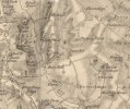
One of the gates into Sutton Park off Chester Road is named after Saltbox as the (apparently distinctive) building was visible from there. From the above link, "Saltbox Gate is named after a distinctive building that once overlooked the western edge of what was then Perry Barr common; on land that is today occupied by the Sundridge Children's Centre. The 1779 Plan and Measurement Map of Sutton Park shows the common stretching west from the Chester Road towards what is today the Queslett Road. The 1824 Enclosure Map shows the former common under the ownership of Perry Barr Common Farm located beneath the houses that sit today where George Frederick Road meets the northern corner of the covered reservoir on Rough Road.
A saltbox is a building with an asymmetrical gabled roof resembling the boxes in which table salt was once kept."
A little trivia: Salt box houses are a phenomenon in New England particularly Cape Cod (salt boxes) settled by the Quakers from, you know where! That style is still being built in Massachusetts, New Hampshire, Vermont, Maine as well as some Southern coastal areas such as North & South Carolina.
 
Back
Top