• Welcome to this forum . We are a worldwide group with a common interest in Birmingham and its history. While here, please follow a few simple rules. We ask that you respect other members, thank those who have helped you and please keep your contributions on-topic with the thread.

    We do hope you enjoy your visit. BHF Admin Team
  • HI folks the server that hosts the site completely died including the Hdd's and backups.
    Luckily i create an offsite backup once a week! this has now been restored so we have lost a few days posts.
    im still fixing things at the moment so bear with me and im still working on all images 90% are fine the others im working on now
    we are now using a backup solution

Pinfold Street

horsencart

master brummie
I was today in Pinfold St (enter at you own peril) and they have dug a service trench for the future development of the tram, as I passed one of the shops a brick Wall? caught my attention, in that it had that very old look about it, they other that I did not notice till I saw of the computer screen how poorly built the thing was, it does not go the full length of the shop and it starts about a foot (I do not do metric) below the pavement, any thoughts on what it was, my own thoughts are that it may have been a service entrance to pass goods and the like through , or was it for the night soil man? here are two photos see what you think,

https://www.flickr.com/photos/dofartshavelumps/19975514271/in/dateposted/

https://www.flickr.com/photos/dofartshavelumps/19349326213/in/photostream/


This is from the shop next door

https://www.flickr.com/photos/dofartshavelumps/19976235061/in/dateposted/

P S The shop next door has a brick wall but appears to be concave, my first thoughts were that it may be drainage but I suspect it aint,
 
Given the recent Metro activity around Victoria Square and the finding of an old road surface, something tells me it might be worth having a little look at Pinfold Street.

Here's an image from 1890. Its been on the Forum somewhere before. But to me it's a strange street and often overlooked. The ground level premises at the top of the street (right) look like they're sunken below the hill at that point. Maybe there was once a short flight of steps down at that point. Or perhaps the premises were built to look like that.


Surprisingly, those buildings are still there today. Viv.

IMG_0097.JPG

IMG_0111.JPG
 
I've copied Stitcher's photo (post #2) of the other side of Pinfold Street to this thread as it's a good view up towards Victoria Square. But what is the first word of the sign "...... Church Schools" ? Is it Christ ? Viv
 
All the buildings on the left side of Pinfold Street in post #2 image have gone. Even the GPO building hadn't been built at the time of the photo. Viv.
 
Pinfold Street in 1865. The lower drawings show buildings which disappeared when the railway was built. Nice to see Christ Church Schools on the third drawing. Viv.

IMG_0153.JPG


IMG_0154.JPG
 
Viv
There is a section missing from the panorama. Here is a lower resolution view of the entire panorama

Pinfold%20St%20publi%26%23115.JPG
 
With the Centenary Square dig, I did assist with the history. That was a major site for uncovering the private canal basins and the Winfield Works. Pinfold Street is only a short section of road that formed a junction with others. In fact this junction became the top of New Street (80), Ann Street, Paradise Street and Pinfold Street. On the corner where this bit of road remained was No 1 Pinfold Street, the Coach & Horses
 
Looking at this old photo of The Coach & Horses, the top of Pinfold Street looks to be in a slightly different position back then to that of today.

City Pinfold St  Coach & Horses Stores.JPG
 
Presumably, the Coach & Horses is at the top of Pinfold Street in Stitcher's photo in post #2. I've traced back newspaper references to the C& H to the 1861, but to me the pub looks older. Did it have an earlier name ? Viv.
 
So I think this 1875 image must show the Coach & Horses/The Stores near the first cart on the right. Proprietor was Mr Hillman. It has 'The Stores' and Hillman on the building. Phil's photo in post #11 shows it connected to the Coach & Horses along that top part of Pinfold Street.

It must have been a large business, occupying a large part of that corner of Pinfold Street. It seems to have been referred to as "Joe's" and was very well known. I've seen The Stores on this corner alternatively referred to in the 1860s as being on Paradise Street.

Ironic that Corbett's Temperance Hotel was such a near neighbour. Viv

IMG_0181.JPG

IMG_0183.JPG

IMG_0186.JPG
 
Last edited:
Another photo of The Stores on the corner of Pinfold Street, this one is dated 1888 which I believe could have only been shortly before it was demolished in 1889 to make way for the new Central Post office.

City Pinfold St (2).jpg
 
Another two photos of Pinfold Street, one dating from the 50's and another looking up the street from Navigation Street in what looks to be the 1960's.

City Pinfold St .jpg City Navigation St - Pinfold St.jpg
 
I think it should be made clear that the Stores of Joseph Hillman was separate from the Coach & Horses. Both are listed in the 1884 Kellys separately with different owners. The Coach & Horses had disappeared from the 1888 Kellys, though Hillman's is still listed
 
That's odd Mike. As Phil's photo in #11 (far left) has a sign reading:

Coach & Horses
Stores
Hillman

To me that suggests they were all once connected although they might have been listed as separate businesses. Hillman must have sold the 'bar' by the 1880s.


Viv.
 
Can we tell from Phil's first photo in post #16 whether the top of Pinfold Street was raised on that side ? Viv.
 
Viv

I think it has always been pretty much the same on that side of street, well at least from the time we first had cameras that could record it. I've never seen any earlier drawings of Pinfold Street.

pinfold.JPG
 
Viv
Where does it say Coach & Horses. can see The Stores, and below it J Hillman, but nothing else. the c1889 map shows the coach and horses down Pinfold St , and on the edge of the corner, and The Stores (PH) next to it.
map c 1889 showing  The sotres & coach and horses.jpg
 
Hi Mike. Probably got this mixed up, but this is what I mean. The left building shows all names on that building. Viv,

Image below copied from post #11.
 

Attachments

  • IMG_0207.JPG
    IMG_0207.JPG
    108.5 KB · Views: 25
Sorry Viv. Was looking at the wrong picture. Yes it does say hillman over the door, and it says wine and spirits stores , but not "The stores". Hillman must have owned both at one time, but separated them before they were demolished
 
Great stuff.....here's a little reminder of it's long history....probably by Carl Chinn...cant remember.....
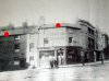
Pinfold Street

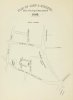
In the Middle Ages and afterwards each settlement had a pound in which stray animals were kept until they were redeemed by their owners who had to pay a fine. Such a pound was often called a pinfold and it was placed at the end of Peck Lane. Called Pynefold Lane it is noted in a lease from King Edward's School in 1656 and in 7131 it is shown on Westley's Plan. Two years later the junction of the two streets became the site of an unsavoury building - the town dungeon. Called Bridewell House it replaced the former jail, a dry cellar in a house. According to Hutton of all the bad places the Bridewell was the worst, for it was 'dark, narrow, and unwholesome within; crowded with dwellings, filth, and distress without, the circulation of air is prevented'. In 1757, the three houses fronting Peck Lane were taken down to enlarge the prison, and it remained in use until a new prison was built in Moor Street in l795. Eleven years later the Bridewell was knocked down in 1806
but as Dent put it, the building 'has been immortalised in a sarcastic triplet relating to one of the latest wakes and bull baitings when the authorities of the day:

"Spoiled the wake, And stole the stake,
And took the bull to the Dungeon".'

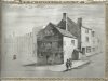
An article in the Birmingham Post in 1934 stated that in the nineteenth century townsfolk talked of going to the city when going to Pinfold Street. Today the street goes down from Victoria Square only as far as Navigation Street, because its lower section disappeared in the 1850s for the building of New Street Station. This also did away with Peck Lane. Spelled as Pecke Lane, this is mentioned in 1565 in a lease from King Edward's school, which disproves the entry in Showell's Dictionary of Birmingham that it was originally named Feck Lane. It may have been called after the Peck family, as an Elizabeth Peck is mentioned as a property owner in a deed from 1715.

In the eighteenth century Joe Lindon's Tavern in Peck Lane was the favoured meeting place of the 'Twelve Apostles', a group of dyed in the wool Tories opposed to the Jacobins, a group of twelve reformers led by Poet Freeth (see Freeth Street). It was a time of turbulent political debate, for the French Revolution in 1789 had polarised opinions. Over the fireplace of the room in which they assembled The Apostles had a notice declaring was printed, 'No Jacobin admitted here'. On one occasion one of the Jacobins called in at the Tory house. He was James Bisset who compiled the Magnificent Directory in 1808 and he was not welcomed, as Dent explained: one of the company puffed a volume of smoke into his face. Bisset had already suffered many petty annoyances and insolent remarks aimed at him, but this direct and gross insult roused his indignation, and with one blow he felled the offender to the ground. There then ensued a general melee, in which most of the jugs and glasses came to grief, and Bisset was forcibly ejected from the house. The unlucky 'apostle' was sued in the Court of Requests for breakages, amounting to nearly £5, and doubtless learned by bitter experience to abstain from putting in an appearance at Joe Lindon's in future.

By the early years of the nineteenth century Peck Lane had become one of the poorest streets in the town. Langford made plain his distaste, asserting that 'the Jews' Synagogue used to be in that very questionable part of the town at the back of Peck Lane, known as the Froggery. The New Street Railway Station occupies the site of both of these once infamous localities, and their names are, happily, all that remain of them'. However, Joe McKenna points out an interesting survival. The site of the station was sold with its rights of way by the Street Commissioners, before that body
was dissolved in 1851. Eleven years later the Town Council petitioned unsuccessfully for the return of the right of way that had been Peck Lane. Still the London and Birmingham Railway Company did place a footbridge over the station as a voluntary concession and through constant use over 100 years it became a right of way again. When the modern station was built in the 1960s this right of way was maintained although in a more circuitous manner.
 

Attachments

  • 1689 Map.jpg
    1689 Map.jpg
    69.2 KB · Views: 28
  • Pinfold:Navigation St 1830.jpg
    Pinfold:Navigation St 1830.jpg
    1.4 MB · Views: 28
Back
Top