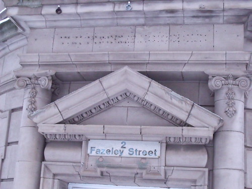
• Welcome to this forum . We are a worldwide group with a common interest in Birmingham and its history. While here, please follow a few simple rules. We ask that you respect other members, thank those who have helped you and please keep your contributions on-topic with the thread.

    We do hope you enjoy your visit. BHF Admin Team
  • HI folks the server that hosts the site completely died including the Hdd's and backups.
    Luckily i create an offsite backup once a week! this has now been restored so we have lost a few days posts.
    im still fixing things at the moment so bear with me and im still working on all images 90% are fine the others im working on now
    we are now using a backup solution

Fazeley street

FAZELEY STREET:DERITEND-DIGBETH

:wink:
FAZELEY Street: can someone such as a student in residence of Prf Br Dr Carl Chinn define the name origin?

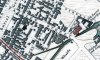
It is a long street from the junction of Heath Mill Lane-Liverpool-Great Bar Streets. There is a small pub on the corner, opposite a cast iron Victorian male urinal (with a hideous, though not uncharacterically so, sodium electrical illumination) 'neath the shattered blue engineering high fire brick arch of the Duddeston Loop railway line. That intersection is actually astonishing as it is a cross of the canal, as Grand Union, the culverted Rea (a stupendous feat of civil engineering in its own right) and what was a cart track. So it is in a certain sense a microcosm.

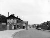
On Virtual-Brum site is a snapshot of the corner tavern and the dilapidated public urinal as well as the cast iron hump back bridge spanning the canal. In their usual miserable ineptitude at taxpayer expense the sight is just awful.

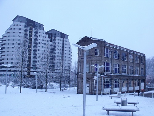
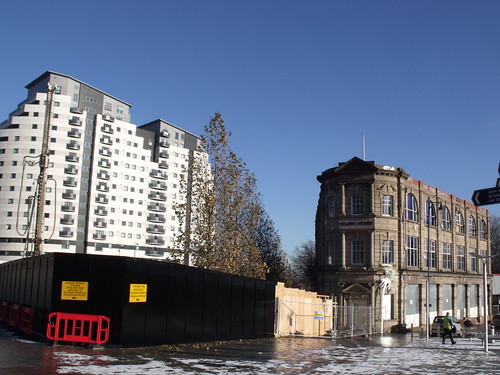
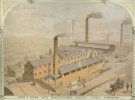
Along Fazeley Street you'll view the British Waterways depot c. 1937. This is a big statement. It is alongside, that W, the old Bond. (Snaps on V-B) It is now an arts and crafts facility in a soon to be developed twin of Brindsley Plot. (Watch for the property speculation price gouging - absolute corker guaranteed. [Eg: Frank Price: 1960s 'redevelopment'])
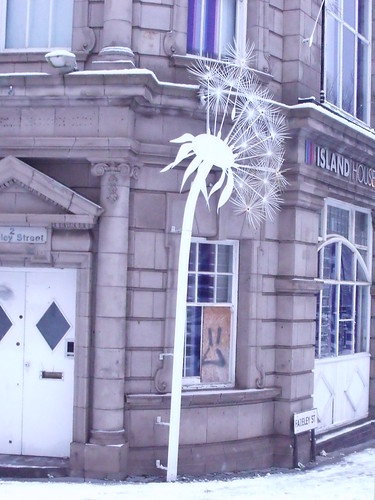
The street is well tarred and is from the forementioned junction to Albert Street. The former Proof House right. Stray Dog home left (facing Dale End: the attrocity of a 'redevelopment') with old railway links about, as Digbeth also left facing thereto and rear is Vauxhall Terminus (now Royal College of Organists), being the twin of Euston as the first intercity (metro) rail link opened 1837.

Also on V-B is a snap of a former Methodicalist temple on Fazeley Street. The opposite (W) side along off Milk was the first municipal development of a form of flats inasmuch as a two storey plot, each being a plumbed one or two bedroom abode. The upper storeys being open walkway wrough cast iron enclosed and with capacious (blue high fire engineering brick layed) enclosed yard for hanging clothes and kinder supervision. The plot was surrounded by factories. That is Digbeth. Deritend is the south Rea. The structure was razed when Frank Price was in office and on the board of Bryants (at least).

Off Fazeley Street, along Great Barr Street, was the first 'high rise' block of flats (Palmer Street) in Britain. I think 12 storeys. Now utilized as a sanctuary for women victims of domestic abuse.

Alongside Fazeley Street, by the canal, was the main inner city garbage dump as incineration.

I do not know why it is so difficult, in daylight, for V-B to post architectural reveals of the area. It might be because of lack of support on the speculative side. However, just off Fazeley Street is Flood Gate Street which is of South Birmingham College whereat Prf Carl Chinn MBE is enjoined of his five year sequestration from UoB as of chair of community history.

You can email, GPO, mayhap telephone his office and perhaps - at considerable taxpayer expense - he can eventuate something of illume for us.

:idea:
 
Does anyone have any maps of Fazeley Street, Birmingham from the early - mid 1960s, if you do post them here

cheers

:)
 
This building is where the yellow dot is on the drawing. The tower behind it is St Phillips. The sketch is reported to be 1865 and do not know what the age of your building is. It may not have been there then. Sketch posted by the exile. Right under the dot is the Gun Barrel Proof House and if you click on one of the posted photo's on Google you will see that the canal end of that building has not changed much.
 
thanks for that info and the drawing rupert..the date on the drain pipe says 1913 but i dont know if that was when the building was built...

lyn.
 
It's uplifting news that this will be saved. Beautiful building, deceptively 'younger' than it looks. Has lots of interesting features. I also like the fact that it was built on a triangular space. A teensy weeny concern (if I'm reading ell's Wikipaedia link correctly), is that the plans look like they include heightening the building. Well maybe some compromises have to be made in order to secure its preservation.......... Viv.
 
I read that one of the cranes had to be dismantled on this site due to the concrete base subsiding if I remember right to the right of this building up the side of Masshouse Lane there was a large grave yard that was removed to build the old Masshouse Circus and a large area of it became the car park.Dek
 
Thank you for bringing this planning appliction to our attention, Barnard. How odd that Island House is claimed to be of low architectural significance!
 
Maybe this is a case where the materials could be re-used in a more useful building...windows, stone etc., Why does it have to be one thing or another when a middle way could be of advantage to all. 'Don't dose re-yose'. I watched a programme about un-used houses on streets in a US suburb being bulldosed recently. Perfectly good houses on a street...not new but seemingly in great shape. People had moved away because of loss of manufacturing jobs. Even prices of $25,000 single houses on 50ft lots did not recieve an offer. After standing for a while the houses were demolished to prevent them from becoming derelict. So you had a street with decent occupied houses remaining with the occasional vacant lot here and there. My point being that the houses were simply bulldosed...perfectly good material...beams and studs...and roughly loaded into a dumpster. What a waste. The material could have been 're-stored' and used to build new houses elsewhere. Maybe an application for demolition should be accompanied with firm plans to re-use valuable material in subsequent renewal structures.
 
fazeley st looking towards gt barr st
 

Attachments

  • Fazeley Street Bordesley looking towards Great Barr Street 1950s to 60s - Copy.jpg
    Fazeley Street Bordesley looking towards Great Barr Street 1950s to 60s - Copy.jpg
    193.1 KB · Views: 91
totally agree richie and dont forget the man in the doorway...this is a perfect photo to click on 3 times as the clarity is great

lyn
 
Hi All

Just working on a bit of a personal project on Fazeley St and the Canal.

In the 1850 History, Gazeteer and Directory of Warwickshire, several businesses are listed at 33 Fazeley St. Would this have been a combined workshops of some kind?

None of these numbered buildings exist anymore, but it would be helpful to know their placing on Fazeley St? Are their any maps that would show the 1850 layout of Fazeley St?

Any information, old photos of Fazeley St or the canal in Digbeth would be appreciated.

Thanks for any help you can give

Louise
 
Have not got a map of that time, but no 33 seems to be on the site of what is listed as "New Steam Mill Co on the 1839 map below, later named Fazeley St Rolling Mills, and in the 1880s New Mill Works
 

Attachments

  • map c 1839A showing position of 33 Fazeley St.jpg
    map c 1839A showing position of 33 Fazeley St.jpg
    200.9 KB · Views: 38
Hi There, my husband’s great great great grandfather is listed as living at 33 Fazeley Stret on the 1881 census. He was 63 years old at the time. Is it likely that the workers also lived in the site of the mills. I would be very interested in knowing more about Fazeley street and the canal district .
 
Brilliant image Dennis, Sharp and Brown were at No. 33 Fazeley Street (I suspect this became Lower Fazeley Street on the 1889 map attached). I can't work out the exact position, useful reference points are the railway viaduct in the distance, proximity to the canal/wharf and perhaps the chimney positions.
 

Attachments

  • lower-fazeley-st.jpg
    lower-fazeley-st.jpg
    890 KB · Views: 22
Back
Top