-
Welcome to this forum . We are a worldwide group with a common interest in Birmingham and its history. While here, please follow a few simple rules. We ask that you respect other members, thank those who have helped you and please keep your contributions on-topic with the thread.
We do hope you enjoy your visit. BHF Admin Team -
HI folks the server that hosts the site completely died including the Hdd's and backups.
Luckily i create an offsite backup once a week! this has now been restored so we have lost a few days posts.
im still fixing things at the moment so bear with me and im still working on all images 90% are fine the others im working on now
we are now using a backup solution
You are using an out of date browser. It may not display this or other websites correctly.
You should upgrade or use an alternative browser.
You should upgrade or use an alternative browser.
Bridge Street/holliday Street Old House
- Thread starter vanessa
- Start date
Some great info coming out here! Another observation. In the 1935 aerial view I posted #70 ( from Britain from the Air site), the track that passes in front of the terrace carries on up towards the canal and runs quite some way south along the wharf buildings, parallel with the canal. So the gateway/entrance that I thought was in one of Lyn's photos (second photo first red arrow) must have been an entrance to that section of wharf buildings. And it would have given access to this area from the cottages.
By the 1930s the aerial photo shows there to be very little domestic housing left. Also the Central Goods Station was earlier known as Worcester Wharf station. Viv.
By the 1930s the aerial photo shows there to be very little domestic housing left. Also the Central Goods Station was earlier known as Worcester Wharf station. Viv.
Attachments
Also meant to say in my last post that I wonder if the terrace of cottages was connected to the Central Goods Station/Worcester Wharf activity as the track runs alongside the station yards. Would the cottages have either been adapted from canal use to railway use or canal/railway use?. Viv.
H
Happyguy
Guest
A very interesting thread, i love the photos.
This is a better copy of Ackerman's 1847 view I posted in post #79. It's an annotated version from this site but very useful to see the tracks of the canals. (Map is from https://www.jquarter.org.uk/webdisk/more2.htm )
I've put a green dot where I think our cottages might be? May be wrong, so glad for any advice. Also, if it is our terrace, it looks like it might have been part of a row which went right up to the canal wharf. Viv.
I've put a green dot where I think our cottages might be? May be wrong, so glad for any advice. Also, if it is our terrace, it looks like it might have been part of a row which went right up to the canal wharf. Viv.
Attachments
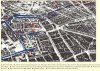
Know what you mean about the angle Mike, although I think Ackerman's could have been less accurate as it was a more pictorial representation. Don't know if it was known to be a pretty accurate representation though.
Been trying to keep a grip on things in my mind, so are we now thinking this terrace is between 1847 and the 1870s? Or have I lost the plot? If it was pre-1870 my guess is it was built by the canal company. If it was in the 1870's I'd say the railway built it. But then on the other hand ............ ! Viv.
Been trying to keep a grip on things in my mind, so are we now thinking this terrace is between 1847 and the 1870s? Or have I lost the plot? If it was pre-1870 my guess is it was built by the canal company. If it was in the 1870's I'd say the railway built it. But then on the other hand ............ ! Viv.
I thnk in the 1870s the railway may have bought up the land (including the terrace) because the access up past the cottages and along that track parallel to the railway yards would have been useful for access to both canal and railway. And I think this access was required because timber was still being transported via canal. Now that's all off the top of my head. Could be a completely misguided hypothesis, so other suggestions/corrections/additions very welcome! Viv.
It would be interesting to see the inside, there might be a clue in there .....:anonymous:
Lyn. And your next mission looks like it involves a helicopter, ropes, a black skintight wetsuit and a box of Black Magic! Viv.
Lyn. And your next mission looks like it involves a helicopter, ropes, a black skintight wetsuit and a box of Black Magic! Viv.
viv are you trying to get me banned for bringing the forum into disrepute lol lol..
shyster2008
proper brummie kid
Hi to all...
The house that is in this Thread is next door to the "Farriers" who used to shoe Horses for the Police in 1967 when i used to be a Cashier for Birmingham Health Department and delivered the Farriers Wages to him...Used to pass this house every Friday...
Spent many a cold friday morning with him brewing up tea on the Farriers brazier.....Took 2 Seconds to make the Tea...2 spoons of tea, 4 spoons of sugar and the water...On the Brazier and put the bellows into action.....2 seconds and you had boiling hot tea..Add the milk and all was ready.....Tasted of burnt horses hooves but went down beautiful...Used to look forward to my friday pay rounds!!!!!
What memmories.
Brian.
P.S. Public Health Dept used to be in Paradise St in those days and I watched the "New" Library going up whilst I worked....Now gone...Pity....I Prattle on...Too many memmories...
Hope the Info is useful...
shyster2008
proper brummie kid
Can I have some Black Magic too????...Would go nice for an after Dinner Treat!!!
Brian
Brian
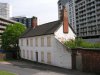
Derelict_UK - fallen into disuse Maurice! Does make you wonder what the state of the inside is. Although it doesn't seem to have any warning notices on the building, so maybe it's quite sound inside. The roof looks in tact and I notice it's had a lick of paint in recent times, possibly because of the hotel. They wouldn't want an eyesore on their doorstep. Wonder when it was last used? Viv
")
Hi to all...
The house that is in this Thread is next door to the "Farriers" who used to shoe Horses for the Police in 1967 when i used to be a Cashier for Birmingham Health Department and delivered the Farriers Wages to him...Used to pass this house every Friday...
Spent many a cold friday morning with him brewing up tea on the Farriers brazier.....Took 2 Seconds to make the Tea...2 spoons of tea, 4 spoons of sugar and the water...On the Brazier and put the bellows into action.....2 seconds and you had boiling hot tea..Add the milk and all was ready.....Tasted of burnt horses hooves but went down beautiful...Used to look forward to my friday pay rounds!!!!!
What memmories.
Brian.
P.S. Public Health Dept used to be in Paradise St in those days and I watched the "New" Library going up whilst I worked....Now gone...Pity....I Prattle on...Too many memmories...
Hope the Info is useful...
Thanks Shyster2008. Can you remember where exactly the farriers was? Were there other buildings near to the terrace of cottages? Or do you mean one of the cottages was the farriers?
Thanks Mike. Of course, you're right, Milk Tray. Don't know where the Black Magic came from. Yes, two walls between the terrace and the Goods Station does seem to separate it. But was that the only access up to the canal nearest the railway yards?
Lyn. We wouldn't let that happen you're too valuable! Viv.
oldMohawk
gone but not forgotten
I'm now wondering why they didn't paint the back of the house which faces the apartments ?....:friendly_wink:I notice it's had a lick of paint in recent times, possibly because of the hotel. They wouldn't want an eyesore on their doorstep. Wonder when it was last used? Viv
Last edited:
shyster2008
proper brummie kid
Just past the Cottages was a Wooden Gate which led into the Yard where the horses were Stabled...This was to the right of the Cottages...
Perhaps some Research into the Birmingham Mounted Police may throw some more light on the subject....
All I can recall is walking down to the Farriers, under the Arch which is in the `Photo...Past the cottages and into the yard....At my age then, a mere 18 year old, all I was looking for was a GREAT cup of tea, a GREAT excuse not to be at work and talking to a GREAT guy who used to shoe the horses for the Birmingham Police Force... (He reminded me of `Pips` experiences in `Great Expectations`"..)...I`ll tell you, not many people had this privilage.
Hope this helps....
P.S. What happened to the Milk Tray???
Brian.

Where's Derelict_UK when you want him? Haven't seen him around for ages.
Maurice
hi maurice derelict uk is still a member and pops on from time to time...think he has a young family now so not so much time to spare going round with his camera...
lyn
WowBrian, you've earned your box of Milk Tray! Can you remember anything else about the stables in the yard ? Viv.
oldMohawk
gone but not forgotten
I've had a 'Google' and one search led me to the Police Horses thread on the forum ... will continue looking ....:encouragement:Just past the Cottages was a Wooden Gate which led into the Yard where the horses were Stabled...This was to the right of the Cottages... Perhaps some Research into the Birmingham Mounted Police may throw some more light on the subject....
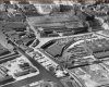
I had a look at this 1999 aerial view but the shadows are not favourable. Looks like cars parked in front at the one end.
View attachment 89623
The cars might be of those employed in the building. I notice there are marks on the front walls in various places of the terrace which might have been business signs. So maybe it was used as offices in the 1990s. Viv.
shyster2008
proper brummie kid
Hi...
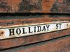
Do not forget that my recollections are from 1967!!!!...Roads change and so do buildings..For example there was no TV studio on the right hand side of Holiday Street in those days and the "Gas Street Basin"...Which was at the end of Holiday Street was not a Tourist Attraction...Holiday Street was just another street....
Google was not around in 1967 so where do you go????? Local Street Maps of the area for that era????
There used to be an HMSO Bookshop on Broad Street...Turn right off Holiday St and it was 1st left.. Not far from the Register Office (Which still survives)...Now gone..But it had all the street maps you needed for the Birmingham Area...
I`m sorry but Google Maps cannot help you for the PAST....Only wish it could...
I`ve not been to the "New" birmingham Library but have memmories of the "Old" one where you can visit the Reference Library....Other Old memmories...
Prattling on again...Sorry...
Brian.