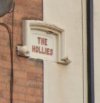
• Welcome to this forum . We are a worldwide group with a common interest in Birmingham and its history. While here, please follow a few simple rules. We ask that you respect other members, thank those who have helped you and please keep your contributions on-topic with the thread.

    We do hope you enjoy your visit. BHF Admin Team
  • HI folks the server that hosts the site completely died including the Hdd's and backups.
    Luckily i create an offsite backup once a week! this has now been restored so we have lost a few days posts.
    im still fixing things at the moment so bear with me and im still working on all images 90% are fine the others im working on now
    we are now using a backup solution

Address plaques and nameplates for Terraces, Villas, Places etc

Digger, that takes us back to 1858 for these plaques so far. I don't yet have a feel for whether any undated plaques are earlier. It's impossible to tell, but I suppose we'd need to find out dates of the commencement and completion of houses/roads to work that out.

Good point ASparks. I think Saltley Housing is quite likely. This one too is simply initials, J.R. Place. It's in Angelsey Street. But I have no idea who this might refer to. Presumably, it's someone or something local.
This website about similar plaques in Loughborough would seem to suggest the initials being the name of the house builder or architect.

 
A cluster of buildings on the Washford Heath Road in Saltley has some interesting plaques - Some with very early dates.
On the one side is a complex of buildings much knocked about over the years - It ends up merging with the Saltley Inn.

37 Washwood Heath Road, Yiewsley Cottage, 1860
39 Washwood Heath Road, Albert Cottage, 1858
41 Washwood Heath Road, Victoria Cottage, 1858
43 Washwood Heath Road, Clyde Cottage, 1860
45 Washwood Heath Road, Havelock Cottage, 1860

On the other side of the road are these...

50 Washwood Heath Road, Vales Wood
52 Washwood Heath Road, Glen Villas

The layout of the building suggests that No 50 is two houses knocked into one and it is the one half of that building that was put up at the same time as No 52 to be the two houses that formed "Glen Villas".
I have corrected the misstype of Washwood in the text, but it remains in the title of the views
 
That's interesting Dinger. I expect archtects and builders could be motivated to add their initials to these signs for a number of reasons. And, of course, I suppose it was also a form of advertising. In the case of parts of Lozells, I understand the design and quality of housing was of a generally better standard in its time than many other developments. So perhaps it was something to be very proud of for those involved in providing housing at a time of rapid population expansion.
 
Alum Rock Road

78-80 Alum Rock Road, Holly Place
82-84 Alum Rock Road, Edith Place
86-88 Alum Rock Road, Compton Place, 1885
115-117 Alum Rock Road, Coomassie Villas (looked it up, it's a place in Ghana that gives its name to a blue dye)
151-153 Alum Rock Road, Mount Pleasant
155-157 Alum Rock Road, Sunny Side Villas
150-152 Alum Rock Road, Fernleigh
162-164 Alum Rock Road, Glenthorpe Villas
179 Alum Rock Road, Beech Mount
183-185 Alum Rock Road, Beaconsfield Villas
189 Alum Rock Road, Highfield Villas (for some reason the street numbering skips here, it's hard to see which buildings formed the "Villas")
195-197 Alum Rock Road, The Palms
223-225 Alum Rock Road, Rock Villas
342-344 Alum Rock Road, Laburnum Villas
354-356 Alum Rock Road, Hawthorn Villas
366-368 Alum Rock Road, Hazelwood Villas
376-378 Alum Rock Road, Park Villas
388-390 Alum Rock Road, Rock Villas (Yes really, another Rock Villas)
400-402 Alum Rock Road, Shaw Villas
 

Attachments

  • Alumrockrd78to80Hollyplace.JPG
    Alumrockrd78to80Hollyplace.JPG
    13.6 KB · Views: 3
  • Alumrockrd195to197thepalms.JPG
    Alumrockrd195to197thepalms.JPG
    16.3 KB · Views: 1
  • Alumrockrd223to225Rockvillas.JPG
    Alumrockrd223to225Rockvillas.JPG
    8.4 KB · Views: 1
  • Alumrockrd342to344labernumvillas.JPG
    Alumrockrd342to344labernumvillas.JPG
    17.7 KB · Views: 1
  • Alumrockrd354to356hawthornvillas.JPG
    Alumrockrd354to356hawthornvillas.JPG
    17.4 KB · Views: 1
  • Alumrockrd366to368hazelwoodvillas.JPG
    Alumrockrd366to368hazelwoodvillas.JPG
    20.6 KB · Views: 1
  • Alumrockrd376to378parkvillas.JPG
    Alumrockrd376to378parkvillas.JPG
    19.2 KB · Views: 2
  • Alumrockrd388to390rockvillas.JPG
    Alumrockrd388to390rockvillas.JPG
    29.8 KB · Views: 2
  • Alumrockrd400to402shawvillas.JPG
    Alumrockrd400to402shawvillas.JPG
    7.6 KB · Views: 2
  • Alumrockrd189highfieldvillas.JPG
    Alumrockrd189highfieldvillas.JPG
    11.7 KB · Views: 2
  • Alumrockrd183to185beaconsfieldvillas.JPG
    Alumrockrd183to185beaconsfieldvillas.JPG
    31.1 KB · Views: 1
  • Alumrockrd82to84Edithplace.JPG
    Alumrockrd82to84Edithplace.JPG
    13.3 KB · Views: 1
  • Alumrockrd86to88Comptonplace.JPG
    Alumrockrd86to88Comptonplace.JPG
    33 KB · Views: 2
  • Alumrockrd115to117Coomassievillas.JPG
    Alumrockrd115to117Coomassievillas.JPG
    47.6 KB · Views: 2
  • Alumrockrd150to152fernleigh.JPG
    Alumrockrd150to152fernleigh.JPG
    40.6 KB · Views: 2
  • Alumrockrd151to153Mountpleasant.JPG
    Alumrockrd151to153Mountpleasant.JPG
    23.3 KB · Views: 1
  • Alumrockrd155to157sunnysidevillas.JPG
    Alumrockrd155to157sunnysidevillas.JPG
    41.4 KB · Views: 4
  • Alumrockrd162to164glenthorpsvillas.JPG
    Alumrockrd162to164glenthorpsvillas.JPG
    21.5 KB · Views: 3
  • Alumrockrd179beechmount.JPG
    Alumrockrd179beechmount.JPG
    32 KB · Views: 5
Last edited:
Have edited the above. I found a better view of 162-164. I originally thought it read "Glenthorps" - but I can see now it's "Glenthorpe".
 
A Friday afternoon virtual walk around Saltley threw up the following plaques...

Malthouse Lane

19-21 Malthouse Lane, Lime Tree Cottages

Parkfield Road

1-7 Parkfield Road, Lillian Villas
2-6 Parkfield Road, Carlton Villas

Bowyer Road

5-7 Bowyer Road, Eovesholm Villas (Eovesholm is apparently an old Anglo-Saxon name for Evesham)
36-38 Bowyer Road, Heathfield Villas
40-42 Bowyer Road, Richmond Villas
44-46 Bowyer Road, Jubilee Villas
51-53 Bowyer Road, The Hollies
55-57 Bowyer Road, The Laurels
59-61 Bowyer Road, May Villas
68-70 Bowyer Road, Clovelly Villas
127-129 Bowyer Road, Gladys Villas
131-133 Bowyer Road, Violet Villas
135-141 Bowyer Road, Olive Villas
 

Attachments

  • BowyerRd5to7Eovesholmvillas.JPG
    BowyerRd5to7Eovesholmvillas.JPG
    22.5 KB · Views: 2
  • BowyerRd51to53thehollies.JPG
    BowyerRd51to53thehollies.JPG
    14.6 KB · Views: 1
  • BowyerRd44to46jubileevillas.JPG
    BowyerRd44to46jubileevillas.JPG
    12.9 KB · Views: 1
  • BowyerRd40to42richmondvillas.JPG
    BowyerRd40to42richmondvillas.JPG
    7.3 KB · Views: 2
  • BowyerRd36to38heathfieldvillas.JPG
    BowyerRd36to38heathfieldvillas.JPG
    23 KB · Views: 2
  • BowyerRd55to57thelaurels.JPG
    BowyerRd55to57thelaurels.JPG
    17.5 KB · Views: 1
  • BowyerRd59to61Mayvillas.JPG
    BowyerRd59to61Mayvillas.JPG
    22 KB · Views: 1
  • BowyerRd68to70clovellyvillas.JPG
    BowyerRd68to70clovellyvillas.JPG
    30.9 KB · Views: 1
  • BowyerRd127to129gladysvillas.JPG
    BowyerRd127to129gladysvillas.JPG
    27.2 KB · Views: 1
  • parkfieldrd1to7lillianvillas.JPG
    parkfieldrd1to7lillianvillas.JPG
    17.7 KB · Views: 1
  • malthouselane.JPG
    malthouselane.JPG
    30.6 KB · Views: 1
  • BowyerRd135to141Olivevillas.JPG
    BowyerRd135to141Olivevillas.JPG
    43.2 KB · Views: 1
  • BowyerRd131to133violetvillas.JPG
    BowyerRd131to133violetvillas.JPG
    21.4 KB · Views: 1
  • parkfieldrd2to6carltonvillas.JPG
    parkfieldrd2to6carltonvillas.JPG
    20.2 KB · Views: 2
And a cluster of plaques in College Road, Saltley...

80 College Road, Ash Villa
82 College Road, Oak Villa
86 College Road, Holly Villa
88-90 College Road, Maple Villas
94-102 College Road, Ivy Villas (the plaque is obscured by a drainpipe running over the middle - but I can't think what else it could be but "Ivy")
106-108 College Road, West View
 

Attachments

  • CollegeRd80AshVilla.JPG
    CollegeRd80AshVilla.JPG
    15.2 KB · Views: 1
  • CollegeRd82OakVilla.JPG
    CollegeRd82OakVilla.JPG
    14.6 KB · Views: 1
  • CollegeRd106to108Westview.JPG
    CollegeRd106to108Westview.JPG
    22.2 KB · Views: 3
  • CollegeRd94to102IvyVillas.JPG
    CollegeRd94to102IvyVillas.JPG
    28.8 KB · Views: 5
  • CollegeRd88to90MapleVillas.JPG
    CollegeRd88to90MapleVillas.JPG
    16.1 KB · Views: 5
  • CollegeRd86HollyVilla.JPG
    CollegeRd86HollyVilla.JPG
    15.5 KB · Views: 3
Last edited by a moderator:
There's a definite pattern in some streets while other streets seem completely random name choices. So far names of trees, ladies first names and references to places seem to be favourites. The ladies names seem very much reflect the popular names of the time in Dinger's post #67. Dinger's College Road selection has a horticultural theme - and there probably wasn't a tree in sight when the houses were built !

I'd like to find out a bit more about when houses were built and their builders. Does anyone know if there's a way to find this out ?
 
Hi Viv - I wouldn't be so sure about the trees - The hi-res ordinance survey of 1886 shows Saltley to be mainly "ribbon development" - I'm guessing that all these "Villas" "places" and "Cottages" would have been on the edge of the country when they were originally built - all in turn then quickly surrounded by further development. It was the later Edwardian, and then huge housing estates of the 20s, and 30s that made them into the "inner city" streets we know today -
Here's the map of part of Alum Rock Road in 1886 - the bit next to Havelock Road. - It shows some "Villa" "Cottage" and "Place" names - Interestingly you can see that development has started on the North side of Havelock Road - with individual villas going up, not next to each other, but I'm guessing building plots had already been laid out. - Compare it with a modern google map view of the area...


Thanks Dinger. At last, your last map has enabled me to find plaques above passageways on main road walls or lintels (in this case Alum Rock Road), leading to named terraces or places behind the main road.

These two are at:
Charlton Place, 72 Alum Rock Road
Alum Rock Place, 85 Alum Rock Road

These are shown on the extract of Dinger's map below.
 

Attachments

  • Screenshot_20240308_165954_Samsung Internet.jpg
    Screenshot_20240308_165954_Samsung Internet.jpg
    331.5 KB · Views: 4
  • Screenshot_20240308_164242_Maps.jpg
    Screenshot_20240308_164242_Maps.jpg
    405.4 KB · Views: 4
  • Screenshot_20240308_171155_Maps.jpg
    Screenshot_20240308_171155_Maps.jpg
    338.7 KB · Views: 4
Last edited:
Thanks Dinger. At last, your last map has enabled me to find plaques above passageways on main road walls (in this case Alum Rock Road), leading to named terraces or places behind the main road.

These two are at:
Charlton Place, 72 Alum Rock Road
Alum Rock Place, 85 Alum Rock Road

These are shown on the extract of Dinger's map below.
Wow! That makes perfect sense now! I thought the plaque referred to the building it was on - but it is actually the building that is/was behind the building in some cases.
 
So despite most courts having disappeared, we can still sometimes find evidence of their existence and location on plaques and engraved lintels over alleyways. Thanks for that confirmation Mike.
 
Last edited:
A cluster of plaques with dates at one end of George Arthur Road, nearest Alum Rock Road.

13-15 George Arthur Road, Vickerstaff Place, 1877
25-27 George Arthur Road, Woolwich Place, 1878
35-37 George Arthur Road, Ilkley Villas, 1890

At first glance it seems strange that there should be a gap of 13 years between the buildings at one end of the "terrace" with the other end that look on Streetview to be of a very close architectural style. I thought maybe I was misreading the date of 1890 and it should be 1880.
However, the O/S map for 1889 shows this area in detail (George Arthur Road is on the left side of the map although only "Arthur" is visible). - You can find the position in the street exactly by finding the wide black-painted gated alleyway with the mattress dumped outside, then locating the narrow alleyway opposite it - Then the next alleyway along - both clearly shown on the 1888 map - Then counting up the houses its plain to see that "Ilkley Villas" wasn't there in 1888, so a date of 1890 would be perfect.

There are a couple of plaques on the other side of the street that seem to have never had a name carved on them - (or long-since been erased) - on nos 8-10 and 16-18.


Attachments

  • georgearthurrd13to15VickerstaffPlace.JPG
    georgearthurrd13to15VickerstaffPlace.JPG
    36.7 KB · Views: 3
  • georgearthurrd25to27WoolwichPlace.JPG
    georgearthurrd25to27WoolwichPlace.JPG
    67.3 KB · Views: 4
  • georgearthurrd35to37IlkleyVillas.JPG
    georgearthurrd35to37IlkleyVillas.JPG
    34.6 KB · Views: 4
Another group of plaques with added interest because they show the amazing growth of Birmingham in the 1880s -90s. They are all in an area North of Cannon Hill Park covered by the Ordnance Survey maps of 1888/1889 on the National Library of Scotland website - Here is one showing what was then almost all open fields - The River Rea is still meandering, not yet channelled into straight lines. - Constance Road has been laid out surrounding a cricket ground (the forerunner of Edgbaston cricket ground? ). - Jakemans Road is in the lower right corner with "Raglan Terrace" built (now disappeared under more recent development). Other adjacent maps are also on the National Library of Scotland Website.


The same area on modern Google maps.


I'm not putting up screen grabs of plaques unless they are elaborate or show dates.

Willow Road

4 - 6 Willow Road, Cannon Park Villas 1889
3-5 Willow Road, Prospect Villas
12-14 Willow Road, St Georges Villas
17-19 Willow Road, Brooklyn Villas
22-24 Willow Road, Highbury Villas
23-25 Willow Road, John's Villas
27-29 Willow Road, Elm Villas
28 Willow Road, Woodside Villas
34 Willow Road, Bellevue 1891
31-33 Willow Road, Rose Villas

Jakeman Road

25 -27 Jakeman Road, Ivydene 1896
33-35 Jakeman Road, Tintern Villas
42-44 Jakeman Road, Park Villas
47-45 Jakeman Road, Baytree Villas
49-51 Jakeman Road, Kenchurch Villas
63 Jakeman Road, Cornwall Villas
65 Jakeman Road, Devonshire Villas
72 Jakeman Road, Florence Villa
 

Attachments

  • WillowsRd34Bellevue1891.JPG
    WillowsRd34Bellevue1891.JPG
    30.2 KB · Views: 2
  • WillowsRd4to6CanonPark.JPG
    WillowsRd4to6CanonPark.JPG
    68 KB · Views: 2
  • Jakemanrd25to27ivydene.JPG
    Jakemanrd25to27ivydene.JPG
    9.5 KB · Views: 2
An interesting survival is in the nearby Park Road. One of the houses on the 1889 O/S map is listed as "Perciville" on the map has a stone plaque on it with the name "Percy Villa".

Edit: Added Address for lookup

9 Park Road, "Perciville".
 

Attachments

  • perciville.JPG
    perciville.JPG
    215.7 KB · Views: 5
  • percyvilla.JPG
    percyvilla.JPG
    51.9 KB · Views: 5
Last edited:
And at the risk of straying slightly off topic (I promise I'll go no further!);)

In the nearby Park Hill (called Park Hill Road in the 1889 O/S map) was a house called "The Lions" (on the very edge of the map) - It has now been renamed "The Grange" - But guess what - It has a magnificent pair of Lions over the door...

Edit - Added address.
42 Park Hill, The Lions (Park Hill Road at one time).
 

Attachments

  • Park Hill.JPG
    Park Hill.JPG
    63.4 KB · Views: 8
  • TheLions.JPG
    TheLions.JPG
    81.2 KB · Views: 9
Last edited:
Another interesting survival. As you come out of the city down the Alcester Road, as you pass the boundary between Balsall Heath and Moseley you might have noticed an imposing terrace of large houses on the left (east) side of the road that would not look out of place in Bath or London's Mayfair. They are there on the 1889 O/S map called "Brighton Place" - They still have identical large plaques at each end of the terrace with the name today. On the other side of the road is a pair of large semi-detached houses called "Heathfield" on the 1889 map - They also have identical large surviving name plaques on both houses.

Alcester Road

28-56 Alcester Road, Brighton Place
17-19 Alcester Road, Heathfield.


Attachments

  • AlcesterRoadheathfield.JPG
    AlcesterRoadheathfield.JPG
    20.4 KB · Views: 7
  • AlcesterRoadbrightonplace.JPG
    AlcesterRoadbrightonplace.JPG
    38.3 KB · Views: 7
That's interesting Dinger. They're both almost suggesting it being a detached residence and something grander rather than multiple hones.

That reminds me of a terraced row on Hockley Hill with Albion Place, 51 - 54 Hockley Hill. Built around 1830. The name Albion Terrace is carved into the stucco but only at one end. There are 4 houses in the terrace. Lovely to see these properties have survived.

Screenshot_20240320_064932_Maps.jpgScreenshot_20240320_064833_Maps.jpg
 
Last edited:
That's interesting Dinger. They're both almost suggesting it being a detached residence and something grander rather than multiple hones.

There's something similar on Hockley Hill with Albion Place, 51 - 54 Hockley Hill. Built around 1830. The name Albion Terrace is carved into the stucco but only at one end. There are 4 houses in the terrace. Lovely to see these properties have survived.

View attachment 190127View attachment 190128
yes it is viv and i am always keeping an eye on them when i go past

lyn
 
Last edited:
Wright Road Saltley has very few plaques. Like Dinger in post #76, I'm not displaying individual screen grabs unless they offer more information of interest.


Sunny Bank at 57 (edit) Wright Road is a house intended to stand out from the rest of the road with its more ornate brickwork

There are just a few names on plaques above gated alleyways leading behind the houses

Mount Royal Place, 44 Wright Road
Violet Poace, 40 Wright Road
Kensington Place, 11 Wright Road
 
Last edited:
Thanks Mike. Sunny Bank should be 57 Wright Road. Edited post #82.
 

Attachments

  • Screenshot_20240321_121616_Maps.jpg
    Screenshot_20240321_121616_Maps.jpg
    423.9 KB · Views: 5
That's interesting Dinger. They're both almost suggesting it being a detached residence and something grander rather than multiple hones.

That reminds me of a terraced row on Hockley Hill with Albion Place, 51 - 54 Hockley Hill. Built around 1830. The name Albion Terrace is carved into the stucco but only at one end. There are 4 houses in the terrace. Lovely to see these properties have survived.

View attachment 190127View attachment 190128
I would say very classy “classics”.
 
The 1888/1889 O/S map shows the East side of Ladypool Road being fields between Alfred Street and Birchwood Road. So all of these buildings would have been built after this date. None of the buildings on the other side of the road have plaques.

Ladypool Road

224 Ladypool Road, Brighton Place
238-240 Ladypool Road, Henley Place
246-248 Ladypool Road, Weston Place
278-280 Ladypool Road, Bertha Place - dated 1893
318-320 Ladypool Road, Norway Place

LadypoolRdBertha278to2801893.JPG
 
Again, the 1888/1889 O/S map shows Kingsley Road and one end of Oldfield Road to be open space (the "Pickwick Cricket Grounds"), So these roads would have been built a few years after. - Interestingly the east end of Oldbury Road was called Henry Street on the 1888 / 1889 map.

As a case of preserving a record of these name plaques its worth noting that some have been erased in the latest version of Streetview. - I had to go back a few years to find them.

OLDFIELD ROAD

140-142 Oldfield Road, Hereford Villas
155-157 Oldfield Road, Islington Place
171-173 Oldfield Road, Jesamine Place
175-177 Oldfield Road, Kingston Place
195-197 Oldfield Road, Lynton Place

KINGSLEY ROAD

2-4 Kingsley Road, Priory Villas
6-8 Kingsley Road, Moseley Villas
7-9 Kingsley Road, Oldfield Villas
10-12 Kingsley Road, Kingsley Villas
14-16 Kingsley Road, Half the plaque has been erased. SP or E then maybe an L ---- Vil-------, - Selby Villas maybe?

kingsleyrd14to16.JPG

Most of the plaques are fairly generic, but the one for Oldfield Villas was a bit more elaborate with some fancy brickwork on top of it.

kingsleyrd7to9.JPG

It is fascinating to see the survival of numerous small terraces of houses in this area that are not on a proper street at all - but on a pedestrian walkway, sometimes as an alleyway between two houses. They all seem to be called "Avenues". - For example here's the entrance to Noel Avenue on Oldfield Road.

NoelAvenue.JPG
There are numerous examples of these - perhaps the oddest are those that have actually been converted to a road that comes off the car park at one end of Ladypool Road - The narrow road is called Bewdley Avenue, Milford Avenue and Albert Avenue all within a few tens of yards... Imagine having to park your car there!


Edit----
Although there seems to be some disagreement between Streetview and the the Street sign - Milford or Milton Avenue?
miltonormilford.JPG

On review, there are actually 4 small sets of houses - And there is a sign for "Milford Avenue - So I think Streetview have got it wrong - There should be Bewdley Avenue, Milford Avenue, Milton Avenue and Albert Avenue. - Phew! Wouldn't fancy being a postman there! (or a refuse collector for that matter! - Sorry if this has gone a little off topic!

milford.JPG
 
Last edited:
OMBERSLEY ROAD.
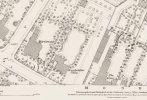
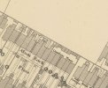
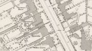
Is this the most "plaqued"road in Birmingham? The 1888/89 O/S map shows it as a long strip of open land, obviously already earmarked for building. So presumably the buildings went up very shortly afterwards. Many of the houses retain their plaques. Unfortunately, there is a gap in Streetview coverage in part of the road. There is a sort of naming convention for a good part of the road, with villas on one side named after trees and plants and on the other named after places, although it is by no means uniform and place names predominate at the eastern end.

16-18 Ombersley Road, Stanley Villas
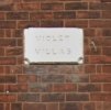
22-24 Ombersley Road, Violet Villas
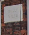
25 Ombersley Road, Ombersley Villa
27-29 Ombersley Road, Hereford Villas
30-32 Ombersley Road, Primrose Villas
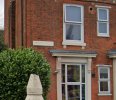
31-33 Ombersley Road, Bolton Villas
34-36 Ombersley Road, Jessamine Villas
35-37 Ombersley Road, Gloucester Villas
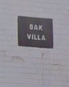
38-40 Ombersley Road, Oak Villas
39-41 Ombersley Road, Cheltenham Villas
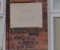
42-44 Ombersley Road, Ash Tree Villas
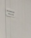
43-45 Ombersley Road, Richmond Villas
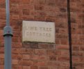
46-48 Ombersley Road, Lime Tree Villas
50-52 Ombersley Road, Sycamore Villas
51-53 Ombersley Road, Highgate Villas
56-58 Ombersley Road, Beech Villas
55-57 Ombersley Road, Moseley Villas
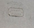
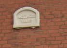
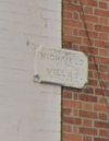
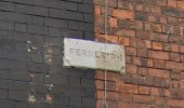
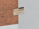
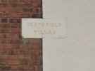
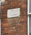
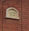
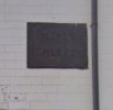
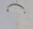
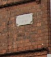
59-61 Ombersley Road, Creet Villas (maybe "Greet"? - See picture)
60-62 Ombersley Road, Fir Tree Villas
63-65 Ombersley Road, Cleeve Villas
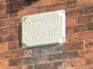
64-66 Ombersley Road, Chestnut Villas
68-70 Ombersley Road, Cedar Villas
71-73 Ombersley Road, Tysley Villas
72-74 Ombersley Road, Acacia Villas
76-78 Ombersley Road, Yew Tree Villas
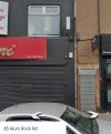
80-82 Ombersley Road, Birch Villas
84-86 Ombersley Road, Clarence Villas
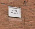
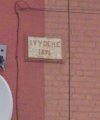
88-90 Ombersley Road, Ivy Villas
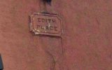
85-87 Ombersley Road, Oakfield Place - Edited to agree with post #90 positioning plaque between two doors.
-----------GAP---------
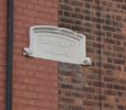
152-154 Ombersley Road, Malvern Villas
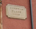
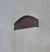
155-157 Ombersley Road, Blenheim Place
156-158 Ombersley Road, Hampton Villas
160-162 Ombersley Road, Bewdley Villas
164-166 Ombersley Road, Hagley Villas
168-170 Ombersley Road, Ternhill Villas
169-170 Ombersley Road, Florence Villas
172-174 Ombersley Road, Arley Villas
176-178 Ombersley Road, Alcester Villas
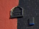
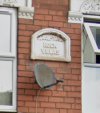
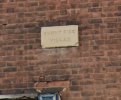
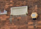
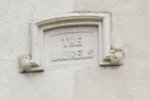
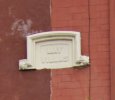
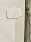
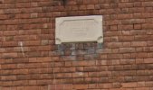
177-185 Ombersley Road, Milicent Villas - with one "L" - Unless someone reads it differently (see photo).

Some alleys lead to terraces that then go out onto Oldfield Road.

Creet or Greet? If it's Creet what does it allude to? Greet would obviously mean the region of Birmingham, especially as there is a Tysley Villas on the Road as well.
Ombersley59to61.JPG

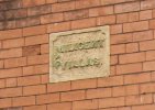
Most of the plaques are very generic - This one is a trifle more elaborate - Milicent? With one "L"?
Ombersleymillicentvillas.JPG
The adjacent Millicent Place terraces, reached through an alley, is spelt with two "L"s.

OmbersleyRoadmillicentandflorenceplace.JPG

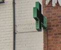
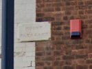
The alley to Brunswick Place with its sign to deter dumping having no effect.
OmbersleyRoadBrunswickplace.JPG
 
Last edited:
Ombersley Road - filling in the "gap".
While Google Streetview does not cover a portion of Ombersley Road, The Bing Maps equivalent does, albeit at much lower resolution. The resolution is too low to read the majority of plaques on the north side of the street, except for two that have the carved letters picked out with black paint.

100-102 Ombersley Road, Albert Villas
118-120 Ombersley Road, Milton Villas

Both have alleyways at the side that run to the rear that match up with the road names "Albert Avenue" and "Milton Avenue" at the rear (see post #87).

On the South side of the street, the plaques are larger and easier to read - They fall into a pattern of housing that seems different to the rest of the street. Here there are blocks of four houses with a covered passageway between them - now all gated off. The name plaques are positioned over the passageways, suggesting they relate to the place accessed through the passageway. A peek into the back gardens using Google satellite view shows these passageways led to long alleys that ran to the back of the gardens, so they are not ginnells. The area at the back seems to have been redeveloped, although there are terraces of houses there. - So here are the name plaques with the numbers on Ombersley street they are positioned between. That just leaves the plaque on No 153 as being the only one on the south side not recorded.

85-87 Ombersley Road, Oakfield Place
99-111 Ombersley Road, Herbert Place
117-119 Ombersley Road, Frederick Place
133-135 Ombersley Road, Inglewood Place

OmbersleyRoadfrederickeplace.JPG

OmbersleyRoadInglewoodeplace.JPG
 
Back
Top