-
Welcome to this forum . We are a worldwide group with a common interest in Birmingham and its history. While here, please follow a few simple rules. We ask that you respect other members, thank those who have helped you and please keep your contributions on-topic with the thread.
We do hope you enjoy your visit. BHF Admin Team -
HI folks the server that hosts the site completely died including the Hdd's and backups.
Luckily i create an offsite backup once a week! this has now been restored so we have lost a few days posts.
im still fixing things at the moment so bear with me and im still working on all images 90% are fine the others im working on now
we are now using a backup solution
You are using an out of date browser. It may not display this or other websites correctly.
You should upgrade or use an alternative browser.
You should upgrade or use an alternative browser.
Vine Inn Lichfield Road Aston
- Thread starter ellbrown
- Start date
Pedrocut
Master Barmmie
This advert in the Birmingham Journal, May 1863, takes the Vine a little further back in time. The advert is for an auction of the pub and suggests it's well established by 1863. The grounds are also described. It includes about an acre of garden land, plus quoits, skittles and bowling alley. Viv.
View attachment 122189
So around this time the Vine would be competing with Aston Lower Grounds? Aston the fun place to be!
Radiorails
master brummie
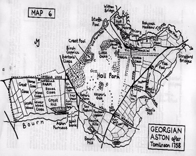
This map, from The Astonbrook through Aston Manor web site shows The Vine Inn but it does look like it was on the other side of the road or maybe premises both sides. The map says after 1758. I believe that this, given its prominent location, would suggest it might have been a coaching inn.
So do we we have another strand to follow?
Last edited:
to be honest alan i didnt think the building looked as old as 1844 as indicated in the great newspaper snippets from viv and mike and i did wonder if it was a later re build of an original vine inn but i am nowhere near qualified to say for certain and without evidence would not presume to say so but now after reading your post i am beginning to wonder...
lyn
lyn
Last edited:
The building is a peculiar shape which suggests to me various add-ons over time. Without getting a good look around, it could be difficult to tell. But shall have a closer look at the photos we have so far and see if I can spot any early features.
Interesting point Pedro, about the Vine's pleasure gardens being in competition with Aston Grounds. The title 'Pleasure Ground' certainly hints at the Georgian fashion for these things. This is all turning into a fascinating snippet of Aston history.
Shall now set up a new thread and transfer all 'Vine' contributions to it. Viv.
Radiorails
master brummie
Hopefully we might get a better result that a recent 'Perry Barr' thread! 
Doesn't add very much, but here is the Tithe map of the area around the Vine . the date is given as 1845, but I think that is publication date and I would guess that it could be a few years before. The mapping of these was not anything like we expect of OS maps, and roads seem to not always be at rigght angles. There is no building shown where the Vine is (red spot.). I think most buildings were supposed to be marked. But, as I say, do not know how accurate the buildings or actual dates were.
The squigglr above the red spot is the plot number (a140), not a building

The squigglr above the red spot is the plot number (a140), not a building
Radiorails
master brummie
Mike, I am a little puzzled by our map (post 39). It shows the canal to the west whereas, as far as I know, the canal is to the east of the Vine. However, in Aston it seems that there are/were three pubs named with vine in their name: (according to the Aston Brook web site)
The Vine - 17, Bracebridge Street
Vine - 157, Lichfield Road - the one under discussion I believe
Vine Inn - 160, Newtown Row.
I mention this to save us getting into a state of confusion - quite an easy achievement I guess for some of us.
The Vine - 17, Bracebridge Street
Vine - 157, Lichfield Road - the one under discussion I believe
Vine Inn - 160, Newtown Row.
I mention this to save us getting into a state of confusion - quite an easy achievement I guess for some of us.
Frothblower
Lubrication In Moderation
I maybe totally wrong ( nothing new there) but the red spot ( The Vine) should be much further up the road?
Alan
As I said, the mapmaking of the map is not up to OS standards .The map is nmot set Nothe up, south down. But the canal is to the east of the vine, it has BIRMINGHAM written along it, on th eright of the vine. The lichfield road (which isnt named on this aprt of the map) runs down to the left of the vine.
As I said, the mapmaking of the map is not up to OS standards .The map is nmot set Nothe up, south down. But the canal is to the east of the vine, it has BIRMINGHAM written along it, on th eright of the vine. The lichfield road (which isnt named on this aprt of the map) runs down to the left of the vine.
Pedrocut
Master Barmmie
Alan
As I said, the mapmaking of the map is not up to OS standards .The map is nmot set Nothe up, south down. But the canal is to the east of the vine, it has BIRMINGHAM written along it, on th eright of the vine. The lichfield road (which isnt named on this aprt of the map) runs down to the left of the vine.
Yes, not SN I had corrected my post.

So Mike's 1845 tithe map shows the building as roughly the same shape. It must have been visible/well known for miles around (despite other buildings not necessarily marked on tithe maps). And it has 'Park' labelled alongside it. So presumably that means Park Road (?) but interestingly none of other roads have labels around there. I think we probably have a significant building here. Would it have been near a toll gate ? Viv.
viv mikes first snippet on post 29 mentions the turnpike road yes i would think there was a toll gate nearby just trying to find one marked on a map...i think where it says park is park st which is still there and marked on mikes maps post 20
lyn
lyn
Last edited:
Pedrocut
Master Barmmie
Bill Dargue states that the turnpike was set up from Birmingham along the Lichfield Road as far as Watford Gap in 1807.
For reference, the OS Map of 1887/8 shows the end of Corporation Street, then Aston Street to Gosta Green, It then becomes Aston Road until Aston Brook Street, where it becomes Aston Road North until Aston Cross. From Aston Cross it becomes Lichfield Road.
In 1834 the Aston Brook Mill comes up to Let. I think it would be at Aston/Hockley Brook near the present Aston Brook Street. It is advertised as on Lichfield Road. So maybe the toll gate would be nearer to Birmingham than the Vine?
It may also be that, in the earlier days, the road from the Toll Gate towards Lichfield would be more well-known as “the Lichfield Road.”
In the book History of Birmingham, by Hutton 1835 he says....“The roads to Lichfield and Coleshill, now Aston and Coleshill Streets, extending to Duke Street, the boundary of the manor.”
So Aston Street is quite old, and as the manor boundary was Gosta Green maybe the toll gate was somewhere around this street?
Last edited:


This token for entertainment at the Vine presumably shows the building, although it's difficult to say if it's accurate. The token is in the British Museum. Interestingly J Bandano - keeper of the Vine - also ran the Grand Sultan Divan in Birmingham.
There was a case which went to court where an 'acquaintance' of Mrs Bandano was accused of stealing jewellery from Mr Bandano. They both seem to have led a very colourful life judging by newspaper reports of the time. Viv.


There was a case which went to court where an 'acquaintance' of Mrs Bandano was accused of stealing jewellery from Mr Bandano. They both seem to have led a very colourful life judging by newspaper reports of the time. Viv.
Pedrocut
Master Barmmie
A Sale at the Grand Sultan Divan has been mentioned in “From Birmingham Papers (usually Birmingham Post) 150 Years Ago 1867-“ Post 239.
https://birminghamhistory.co.uk/for...-150-years-ago-1867.47344/page-12#post-596188
Maybe there was table dancing at the Vine.
https://birminghamhistory.co.uk/for...-150-years-ago-1867.47344/page-12#post-596188
Maybe there was table dancing at the Vine.
A report showing Mr Bandano's relationship with the Vine and the Divan is given in the cutting below, the initial report of a robbery, which, as can be seen, caused some amusement in court. the man was found guilty. In august Mr Bandano had been warned by the licensing magistrates about having immoral characters at the Vine at a late hour !


Radiorails
master brummie
The place did have a 'reputation' it seems, so I guess that was the reason for laughter. Many of those old court reports show the hilarity and entertainment that was to be had in older days. But that was before movies and tv.
Many of those old court reports show the hilarity and entertainment that was to be had in older days. But that was before movies and tv.A comparison of the token depiction of the Vine and present day view. The frontage hasn't changed dramatically, mostly at ground level with changes to the entrance.
I wondered if there was ever some sort of brewery on the premises at one time. Hence the odd shape of the building. And most probably any stabling would have been to the rear of the pub, especially on what was (and still is) a busy road. Viv.

I wondered if there was ever some sort of brewery on the premises at one time. Hence the odd shape of the building. And most probably any stabling would have been to the rear of the pub, especially on what was (and still is) a busy road. Viv.