• Welcome to this forum . We are a worldwide group with a common interest in Birmingham and its history. While here, please follow a few simple rules. We ask that you respect other members, thank those who have helped you and please keep your contributions on-topic with the thread.

    We do hope you enjoy your visit. BHF Admin Team

Yardley And Solihull Places Of Interest...to Say The Least...

Dennis Williams

Gone but not forgotten
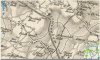
Here's one for you historians....this 1798 map of the surrounds of Yardley and Solihull fascinates and confuses me ....I mean, apart from actually listing the Custard Ho use in Blake lane...a pub fer heaven's sake!....it also marks some other spots that I have never heard of....listed here and ringed on the map....anyone got anything on any of these puzzlers..? Probably known as summat else now...?

From the top down

Gibbets
Lindon Orchard
Tibbits Green
Kineton Hall
Broomfield Hall
Wilkenson Gate
War Hall
Lewd Heath
Eaves Cross
Sandy Hall
Sandals

i know LEWD HEATH? what the hell went on there?!!

1798 Yardley and Solihull 1798 map.jpg
 
I'm fairly certain that there are areas called Kineton Green and Lyndon Green, I'd assume they are in a similar place and named for the halls.

Also some of the areas seems a little out of place compared to the modern areas - Little Bromwich, Small Heath, Alum Rock & Shaw Hill.

Checking on the definition of lewd, originally meant 'belonging to the laity', then 'belonging to the common people'.
 
Dennis
The Custard House pub (then tavern) seems to be from the 1850s. There was a Custard House Farm, and later Custard House from at least 1709. This was on the corner of Hobmoor lane and Yardley Road. the house was demolished soemtime after 1900. So ypur map does not show a pub . I think all this info is somewhere on the forum already. The farm seems to have had an orchard, and it has been suggested that custard is a corruption of costard, a large apple. There seems to be no definite evidence of this however.
 
Kineton Hall looks as if it is roughly where Kineton Green Road is today. Lewd Heath has probably become Lode Heath. Linden Orchard is probably roughly where Lyndon school is today - near Solihull Ice Rink not far from the Wheatsheaf on the Coventry Road. Sandy Hall seems to be where Sandy Hill Road is and my Gran referred to Shirley Street.
 
Its not Sandals, but Sandals Bridge, and would seem to be the name of the bridge near Brueton park on the Warwick road where the road crosses the river Blythe, long since demolished and renamed.
 
Just realised that Sandals Bridge is probably why there is a road called Sandal Rise just off the Warwick Road before you get to Knowle. Three Maypoles must have given its name to the pub now known as the Miller and Carter Solihull. Tythebarn Lane must have a link to Tithe Barn. There are probably others which I haven't spotted. I know this is Solihull not Birmingham but it is where I went to school and grew up.
 
+So far it would appear that Lewd became Lode, which is of course associated with the Rover factory.
There is a Sandy Hill Road which is just beyond the city boundary in the Shirley direction.
Gibbets is a common name in many areas where a hanging would have taken place.
Many of the places mentioned, as Janice points out, are not in Birmingham but Solihull.
I did spot a Coal Bank which is around the area known as Cole Bank (Road). I wonder if that was an alternative spelling of the rivers name?
 
Last edited:
Dennis
The Custard House pub (then tavern) seems to be from the 1850s. There was a Custard House Farm, and later Custard House from at least 1709. This was on the corner of Hobmoor lane and Yardley Road. the house was demolished soemtime after 1900. So ypur map does not show a pub . I think all this info is somewhere on the forum already. The farm seems to have had an orchard, and it has been suggested that custard is a corruption of costard, a large apple. There seems to be no definite evidence of this however.

Copied from the Bordesley thread on the Forum:
Custard House Farm : announcement 20.10.1746 Aris's Gazette.
To be Lett (and entered into on Lady-Day). An Estate at Bordesley, in the Parish of aston, two Miles from Birmingham, known by the name of Custard House Farm, now in the tenure of Edward Yardley, of about the Yearly Rent of 80/- per Annum, the House, Barn, Stables and other Buildings, in very good order. Enquire of Mr George Riland, of Sutton Coldfield, Mr william Saddler of Castle Bromwich, or of Mr Thomas Fisher, Attorney at Law, in New St, Birmingham.


BordesleyExile, Jan 4, 2010Report
#25Like+ QuoteReply
 
I'll have a go at "Broomhall". The name has been traced to 972, Bromhalas, shallow valleys where broom grows. The de Bromhales were landowners in their moated hall. The estate was divided up in C15, but in Tudor times half of Yardley parish was named after the estate. The King family were the holders of the estate in C19. Ref Michael Byrne. "Acocks Green".
Joseph Wheldon Izod farmed there until 1947. Ref Carl Chinn "Streets of Brum"
oops! Fools rush in! Just realised that we are looking for BroomFIELD not Broomhall. I have found a Broom furlong, Crosse fielde in the correct location ie north of Acock's Green, in the C17th. Ref "Medieval Yardley" by Victor Skipp.
 
Last edited:
Maybe 2+2=5! There was a C18 builder Thomas Sandals in Solihull, did he have anything to do with the build of this Warwick Rd bridge?
 
Malvern Park is at the back of the church (St. Alphege) in Solihull town centre, a walk past where the lido was in 1950's, through the present day "arboretum" links to Brueton Park. The gate house is the wrong side of River Blythe for the modern position of the park. Malvern Hall was the on the site of the present day St. Martin's school. I remember a Constable drawing of the hall done from near the old boating pool which I always thought curious didn't have an obvious link to the R. Blythe.
 
Nice web site, I can see what you mean about park land both sides of the Blythe, I guess the gate house must have been a "backdoor" as the track you mention is very small, compared even with the footpath NW from Sandals bridge, the main access to the hall is certainly via Park Rd. to the North West, the map I had been using was 1902.

Screenshot (127).png
 
Last edited:
I nipped down to Sandal's Bridge this morning and the bridge in #17 has a stone inset which states it is "Sandal's Bridge widened in 1924" so it is not the original. The building seems to be a very solid gatehouse - I could see no windows on either end nor on the side facing the road. Just the large double doors in the centre. The house now built behind it is in fact called "the Gatehouse" so perhaps this was a back or service entrance to the grounds.
 

Attachments

  • P1000472.JPG
    P1000472.JPG
    339 KB · Views: 17
Back
Top