• Welcome to this forum . We are a worldwide group with a common interest in Birmingham and its history. While here, please follow a few simple rules. We ask that you respect other members, thank those who have helped you and please keep your contributions on-topic with the thread.

    We do hope you enjoy your visit. BHF Admin Team

Where is Wellington Street?

DavidBrown

proper brummie kid
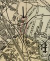
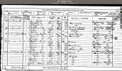
I am following my ancestors, and I find that my great great grandparents, John and Dorothy Waterson, were living in Wellington Street in the 1850s/1860s. She died in 1857 and the burial register from All Saints, Hockley records that she lived at Wellington Street; and the 1861 census has her husband as still living there. This is not the modern Wellington Street off Winson Green Road, because the nearby streets in the 1861 census are Bridge Street West and Farm Street. The earliest map I can see online (the OS 1889 survey) has a clutch of 'Wellington' names off Bridge Street West; there is Waterloo Place, and The Wellington pub on the corner, and Wellesley Street. Is it possible that the Wellington Street of the 1850/1860s was re-named as Wellesley Street as it was developed?
 
The 1855 directory lists 2 Wellington Streets - I assume the one you want is the first one listed.
1626525358117.png
I agree that the only street I can see is Wellesley Street which has the Wellington pub on the corner. This street is not listed in 1855. Of course Arthur Wellesley did become the Duke of Wellington so maybe that is why the name changed.
 
Last edited:
This is the only Wellington St listed in 1900 and is indexed as Handsworth-hope it helps, John.
 

Attachments

  • map1 Handswoth.jpg
    map1 Handswoth.jpg
    472.4 KB · Views: 12
Wellington St, Bridge st west is also listed in the 1862 (though date a bit dubious) Corporation directory, listing 4 names. There is no mention of Wellesley St. however Wellesley st is not mentioned (and then only in a list of streets, no inhabitants listed) till 1883. It would seem peculiar to me that , if they were the saem, there would be no mention in directories for a period of 20 years,.
Immediately before Wellington st in the 1861 census is Melbourne terrace, Bridge st west. This terrace is next to the junction with Burbury st. Burbury st is also listed in the 1862 directory. Hwever , if you look at the description of the enumeration district in 1861 below:

ScreenHunter 2991.jpg
You will see that the entire district comprises houses between Farm St & Bridge St West. The largest part of Burbury st is north of that area , but a small length runs between the two . I would therefore suggest that Wellington st was the part , now Burbury st, marked in red on the c1889 map

map c1889 showing length of burbury st between Farm st and Bridge st west.jpg
 
CORRECTION
I was almost right, but got it the wrong way round I think. After checking the directory for 1855 and 1858, the 1855 directory lists the Burbury arms and the Queens Head in Burbury St which is stated to be off Farm St, , and the 1858 directory states that Burbury St is off 200 Gt King st,. Therefore Wellington St must, at that time, have been a short spike (marked in blue). that also fits with it being next to melbourne terrace, which, as can be seen, is on the north side

map c1889 showing length of burbury st between Farm st and Bridge st west and short spike to n...jpg
 
By the time of the 1867 directory Burbury st stretches from Gt King St to Lozells Lane
 
Thank you, Mike, I was just accepting your first suggestion, but I like the second one as well. Either way it's pretty close to Hockley Hill where their son lived: I have just spent the last three hours reading that fantastic thread ... and am now going back to it!
 
CORRECTION
I was almost right, but got it the wrong way round I think. After checking the directory for 1855 and 1858, the 1855 directory lists the Burbury arms and the Queens Head in Burbury St which is stated to be off Farm St, , and the 1858 directory states that Burbury St is off 200 Gt King st,. Therefore Wellington St must, at that time, have been a short spike (marked in blue). that also fits with it being next to melbourne terrace, which, as can be seen, is on the north side

View attachment 159158
I would agree with this Mike, on the 1871 census Wellington Street is preceded by 'twenty house row' (whatever that is) and followed by 313 Farm Street. There is a Mary O'Neil on the 1861 and 1871 (No. 14) censuses which implies they are the same Wellington Street.
 

Attachments

  • 1871census-wellington-st.jpg
    1871census-wellington-st.jpg
    539.8 KB · Views: 4
I would agree with everything above about Wellington st, but have just realised there is a problem. The map below of 1848 shows Burbury St going up as far a Lozells lane. Things and names were not so set in stone then, however, and frankly I think our explanation is the correct one, and the 1848 map shows an old name, which was reinstated later.

Burbury st shown on 1848 map.jpg
 
I'm still playing with this! My great great grandfather wasn't there long; he died in 1870, but there are several names that crop up in the next census, and beyond. William Wright, a carpenter, born in Bromsgrove in 1832, and his wife Charlotte are there in Wellington Street in 1861 and in 1871, and in Wellesley Street in 1881, and at 331 Farm Street in 1891; he dies before the next census when she has moved to Villa Street. In the 1881 census the run of houses along Farm Street goes up to number 61, then there is Wellesley Street (14 houses), then the numbers continue at 312 onwards with Bevans Buildings (1-14) between 314 and 315. By the time of the 1891 census Wellesley Street is a substantial street with even numbers up to 42 and odd numbers up to 81. Other groups of houses that are offshoots of Farm Street in the 1881 census are Fountains Yard (between 328 and 329), Sandon Terrace (after 348), Hunters Vale (between 383 and 384) and Victoria Cottages (after 400). I imagine that the numbering of houses changed substantially as the roads filled up.
 
Browsing through newspapers in search of my Waterson ancestors I have come across several advertisements in February and March 1862 in the Birmingham Journal for the sale of Leasehold Property in Wellington Street ..."12 houses, in Wellington Street, near the Wellington Inn, Bridge Street, Hockley". My ancestor is listed among the current tenants as are the families Wright, Millard and Mallam, who are all also in the 1861 census. The significant point is the positioning of Wellington Street near the Wellington Inn!
 

Attachments

  • WellingtonStreetSale.1862.png
    WellingtonStreetSale.1862.png
    740.1 KB · Views: 4
In February 1864 reports of a murder in Dartmouth Street in both Aris's Birmingham Gazette and the Birmingham Daily Gazette tell of the murderer, George Hall, going in to "the Wellington Tavern, Wellington Street where he told the landlord and others that he had shot his wife." This time the Wellington Tavern is actually on Wellington Street.

The pub stood at the corner of Bridge Street West and Wellesley Street / Wellington Street. I am now sure they are one and the same and that the name was changed sometime in the early 1870s.
 
Back
Top