-
Welcome to this forum . We are a worldwide group with a common interest in Birmingham and its history. While here, please follow a few simple rules. We ask that you respect other members, thank those who have helped you and please keep your contributions on-topic with the thread.
We do hope you enjoy your visit. BHF Admin Team
You are using an out of date browser. It may not display this or other websites correctly.
You should upgrade or use an alternative browser.
You should upgrade or use an alternative browser.
Tonk Street
- Thread starter josietrue
- Start date
Josie
It is not quite correct ton say Tonks St was hill St. Hill St was there previously, but only ran down as far as the New Inkleys, which was approximately where Station St is now.
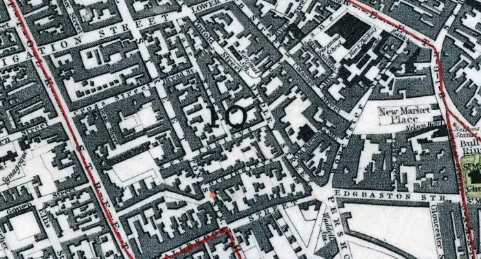
Tonks st was approximately where the remaining length of hill St later was situated, as seen on the c 1839 map below. No 36 seems to be on the east side of Tonks st, just south of Old Inkleys (which is approximately where Hinkley st is now.) i have marked the approx. position of 36 as a red dot on the map.

flossiefoster
master brummie
mikejee, please forgive me for butting in like this - several years after you posted this - but I am looking at what is Worcester Street on the right hand side of the map, going up past the New Market Place. What would this be called today, please? I thought it would be Livery Street as it runs up past Colmore Street but I am far from sure that my bearins are right. I started off being interested in Tonks Str because I think I have a distant ancestor living there on the 1841 Census. Can you help, please? It really is a super map and thank you for posting that portion of it.Josie
It is not quite correct ton say Tonks St was hill St. Hill St was there previously, but only ran down as far as the New Inkleys, which was approximately where Station St is now.
Tonks st was approximately where the remaining length of hill St later was situated, as seen on the c 1839 map below. No 36 seems to be on the east side of Tonks st, just south of Old Inkleys (which is approximately where Hinkley st is now.) i have marked the approx. position of 36 as a red dot on the map.

flossie
If you go to https://maps.nls.uk/geo/explore/#zoom=16&lat=52.4780&lon=-1.8983&layers=6&b=1 and adjust the slider in the bottom left hand corner, which says adjust transparency, then you will see that part of Worcester st is about where Smallbrook Queensway is,
If you go to https://maps.nls.uk/geo/explore/#zoom=16&lat=52.4780&lon=-1.8983&layers=6&b=1 and adjust the slider in the bottom left hand corner, which says adjust transparency, then you will see that part of Worcester st is about where Smallbrook Queensway is,
flossiefoster
master brummie
Thank you, mikejee. I do find the change of names so confusing. I have been trying to compare your 1839 map with A-Z but, of course, that is heavily overlaid with Smallbrook Queensway and others. I will certainly click on your link. Thank you so much for your reply.
Hi mike just reading an article here about the lord mayor,s coachman and its stated that in the city centre Tonk streetwas erased for hill street and in the out laying areas, Sheep street erdington made way for station road in 1887 Donkey laneacocks green was dropped forHarvey road in 1906 Tanyard lane yardley was transformed into Amington road 1907
madcap lane yardley became Graham road in 1927 and Bedlam name northfield gave way to tessall lane in 1927
madcap lane yardley became Graham road in 1927 and Bedlam name northfield gave way to tessall lane in 1927
Hi Mike
I Have just came across a article in an old book i have which i thought might be of intrest to us alland it mentionioned tonk street so i thought i would put this on as a add on to tonk street i have included a picture with it the picture is of
Hil Street [ CITY ]
As its name suggest, Hill street runs down the slope from Victoria Square to smallbrook queens way.
It was called tonk street and some times Tunkeses street until 1879,
Which suggests it was then callled after some ones name named tunks or tonks,
The line of hill street was apparent by mid eighteeth century
Attachments
Astonian
I have now sorted out the problem. The original poster stated that they understood Tonks St was now called Hill St. Ipointed out that that was not quite correct, as Hill St ran down to the end of Tonks St, which later became part of Hill St. Therefore Carl was correct in stating that Tonk St became Hill St, but not that Hill St was once called Tonk St. Tonkfes St is shown on the West's 1730 map (below), before Hill St was built. Presumably the incorporation of Tonk (Tunkfes) St into Hill St in the early 1880s was simplification, as the two streets on the ground were continuous.

I have now sorted out the problem. The original poster stated that they understood Tonks St was now called Hill St. Ipointed out that that was not quite correct, as Hill St ran down to the end of Tonks St, which later became part of Hill St. Therefore Carl was correct in stating that Tonk St became Hill St, but not that Hill St was once called Tonk St. Tonkfes St is shown on the West's 1730 map (below), before Hill St was built. Presumably the incorporation of Tonk (Tunkfes) St into Hill St in the early 1880s was simplification, as the two streets on the ground were continuous.

Hello, I am new here and have been helping my father in law with some information. I found that the brass founder William Tonks began work as a woodscrew maker on 3 Hill Street, before going on to bigger and better things. Could Tonks Street be named after him?
http://www.oldcopper.org/makers/tonks.php
http://www.oldcopper.org/makers/tonks.php
Well Tonks 28
After reading the file there what you have put up the addrees is correct a you say its states number 3 and listing in carl chinns book on hill street history whom done the article on hill street many years ago Which states
Hill street and as the name suggest, hill street runs down a slope from victoria square to small brook street queens way.
It was called Tonk street and some times Tunkses street until1879. which suggest it was then called after some ones name Tunk or tonks
The line of hill street was apparent by the mid eighteenth century so there fore there is the possibility it is yoour relie best wishes Alan Astonian;;;;;
flossiefoster
master brummie
Thank you for that, mikejee. It's a lovely map which I find fascinating.Astonian
I have now sorted out the problem. The original poster stated that they understood Tonks St was now called Hill St. Ipointed out that that was not quite correct, as Hill St ran down to the end of Tonks St, which later became part of Hill St. Therefore Carl was correct in stating that Tonk St became Hill St, but not that Hill St was once called Tonk St. Tonkfes St is shown on the West's 1730 map (below), before Hill St was built. Presumably the incorporation of Tonk (Tunkfes) St into Hill St in the early 1880s was simplification, as the two streets on the ground were continuous.
View attachment 127657


